Canoinhas elevation
Canoinhas (Santa Catarina), Brazil elevation is 779 meters and Canoinhas elevation in feet is 2556 ft above sea level [src 1]. Canoinhas is a populated place (feature code) with elevation that is 397 meters (1302 ft) bigger than average city elevation in Brazil.
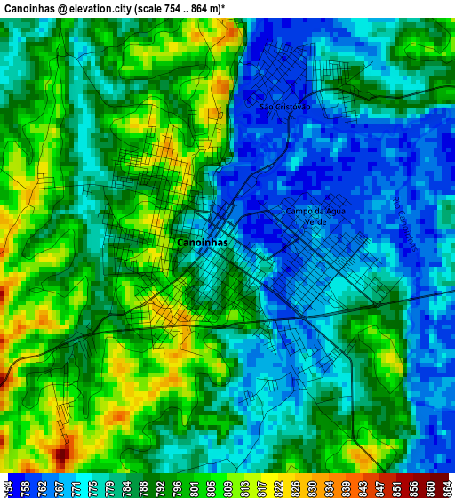
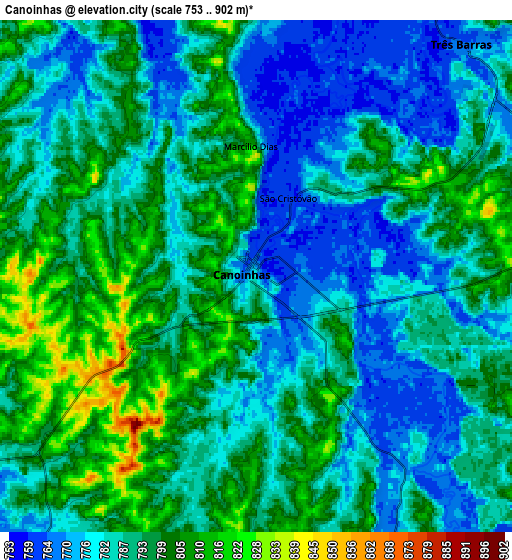
Below is the Elevation map of Canoinhas, which displays elevation range with different colors. Scale of the first map is from 754 to 864 m (2474 to 2835 ft) with average elevation of 786.8 meters (=2581 ft) [note 1]
These maps also provides idea of topography and contour of this city, they are displayed at different zoom levels. More info about maps, scale and edge coordinates you can find below images.
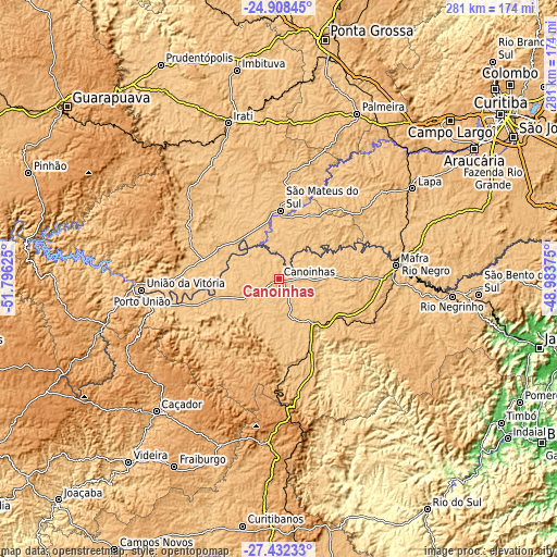
| \ | Map #1 | Map #2 | Topo.Map |
| Scale [m] | 754..864 m | 753..902 m | × |
| Scale [ft] | 2474..2835 ft | 2470..2959 ft | × |
| Average | 786.8 m = 2581 ft | 789.6 m = 2591 ft | × |
| Width | 8.77 km = 5.4 mi | 17.54 km = 10.9 mi | 280.6 km = 174.4 mi |
| Height | 8.77 km = 5.4 mi | 17.54 km = 10.9 mi | 280.6 km = 174.4 mi |
| ↑Max Latitude | -26.137775° | -26.098317° | -24.90845° |
| Latitude at center | -26.17722° | -26.17722° | -26.17722° |
| ↓Min Latitude | -26.216651° | -26.256069° | -27.43233° |
| ← Min Longitude | -50.433945° | -50.477891° | -51.79625° |
| Longitude center | -50.39° | -50.39° | -50.39° |
| →Max Longitude | -50.346055° | -50.302109° | -48.98375° |
Nearby cities:
Cities around Canoinhas sort by population:
• Caçador elevation 916 m
91.1 km,  223°
223°
• União da Vitória 759 m
69.7 km,  265°
265°
• Irati 848 m
83.2 km,  341°
341°
• Rio Negrinho 793 m
87.4 km,  95°
95°
• Mafra 806 m
58.8 km,  82°
82°
• Porto União 783 m
69 km,  264°
264°
• Lapa 929 m
81.2 km,  56°
56°
• São Mateus do Sul 792 m
33.7 km,  1°
1°
• Rio Negro 795 m
59.7 km, 82°
• Palmeira 913 m
91.6 km,  24°
24°
• Santa Cecília 1097 m
87.2 km,  182°
182°
• Três Barras 767 m
10.4 km,  40°
40°
Multilingual:
 En español:
Canoinhas elevación 779 m.
 En France:
Canoinhas élévation 779 m.
 Auf Deutsch:
Canoinhas höhe über dem Meeresspiegel ist 779 m.

Sources and notes:
- [note 1] Map square and city borders are not equal. Map elevation data is calculated only from area inside that square.
- [src 1] Elevation data from geonames database provided with same terms of usage.
- [src 2] The elevation map of Canoinhas is generated using elevation data from NASA's 3 arcsec (90m) resolution SRTM data.
- [src 3] Base (background) map © OpenStreetMap contributors tiles are generated by Geofabrik and OpenTopoMap.
Copyright & License:
This Canoinhas Elevation Map is licensed under CC BY-SA. You may reuse any part from this page, if you give a proper credit by linking to this URL:
 More info on terms of use page.