São Bento do Sul elevation
São Bento do Sul (Santa Catarina), Brazil elevation is 863 meters and São Bento do Sul elevation in feet is 2831 ft above sea level [src 1]. São Bento do Sul is a populated place (feature code) with elevation that is 481 meters (1578 ft) bigger than average city elevation in Brazil.
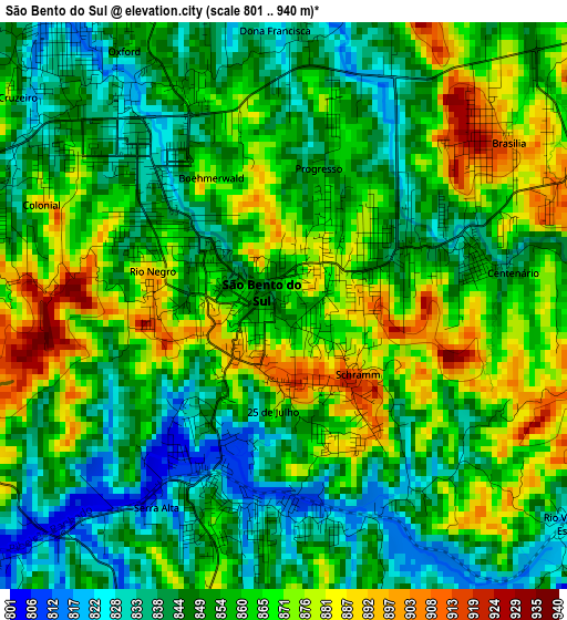
Below is the Elevation map of São Bento do Sul, which displays elevation range with different colors. Scale of the first map is from 801 to 940 m (2628 to 3084 ft) with average elevation of 857.4 meters (=2813 ft) [note 1]
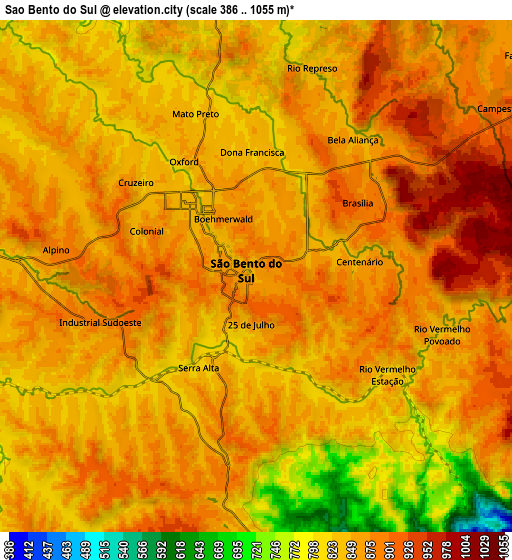
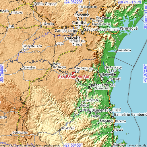
These maps also provides idea of topography and contour of this city, they are displayed at different zoom levels. More info about maps, scale and edge coordinates you can find below images.
| \ | Map #1 | Map #2 | Topo.Map |
| Scale [m] | 801..940 m | 386..1055 m | × |
| Scale [ft] | 2628..3084 ft | 1266..3461 ft | × |
| Average | 857.4 m = 2813 ft | 851.6 m = 2794 ft | × |
| Width | 8.76 km = 5.4 mi | 17.53 km = 10.9 mi | 280.5 km = 174.3 mi |
| Height | 8.76 km = 5.4 mi | 17.53 km = 10.9 mi | 280.5 km = 174.3 mi |
| ↑Max Latitude | -26.21086° | -26.171427° | -24.98229° |
| Latitude at center | -26.25028° | -26.25028° | -26.25028° |
| ↓Min Latitude | -26.289687° | -26.32908° | -27.50458° |
| ← Min Longitude | -49.422555° | -49.466501° | -50.78486° |
| Longitude center | -49.37861° | -49.37861° | -49.37861° |
| →Max Longitude | -49.334665° | -49.290719° | -47.97236° |
Nearby cities:
Cities around São Bento do Sul sort by population:
• Joinville elevation 9 m
53.5 km,  96°
96°
• Jaraguá do Sul 27 m
40.7 km,  130°
130°
• Araucária 886 m
73.1 km,  357°
357°
• Rio Negrinho 793 m
13.9 km,  268°
268°
• Mafra 806 m
45.3 km,  289°
289°
• Timbó 69 m
64.6 km,  170°
170°
• Lapa 929 m
63.2 km,  327°
327°
• Rio Negro 795 m
44.8 km, 291°
• Pomerode 64 m
58.1 km,  159°
159°
• Guaramirim 34 m
44.9 km,  123°
123°
• Schroeder 46 m
35.4 km, 120°
• Corupá 66 m
23.7 km,  145°
145°
Multilingual:
 En español:
São Bento do Sul elevación 863 m.
 En France:
São Bento do Sul élévation 863 m.
 Auf Deutsch:
São Bento do Sul höhe über dem Meeresspiegel ist 863 m.

Sources and notes:
- [note 1] Map square and city borders are not equal. Map elevation data is calculated only from area inside that square.
- [src 1] Elevation data from geonames database provided with same terms of usage.
- [src 2] The elevation map of São Bento do Sul is generated using elevation data from NASA's 3 arcsec (90m) resolution SRTM data.
- [src 3] Base (background) map © OpenStreetMap contributors tiles are generated by Geofabrik and OpenTopoMap.
Copyright & License:
This São Bento do Sul Elevation Map is licensed under CC BY-SA. You may reuse any part from this page, if you give a proper credit by linking to this URL:
 More info on terms of use page.