Matipó elevation
Matipó (Minas Gerais), Brazil elevation is 621 meters and Matipó elevation in feet is 2037 ft above sea level [src 1]. Matipó is a populated place (feature code) with elevation that is 239 meters (784 ft) bigger than average city elevation in Brazil.
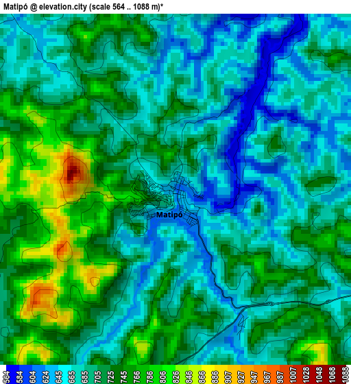
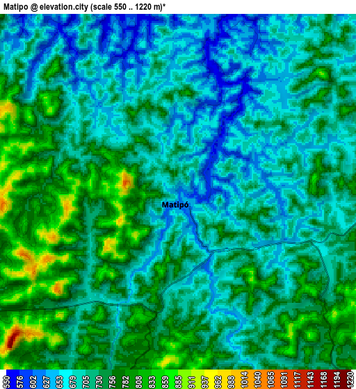
Below is the Elevation map of Matipó, which displays elevation range with different colors. Scale of the first map is from 564 to 1088 m (1850 to 3570 ft) with average elevation of 706 meters (=2316 ft) [note 1]
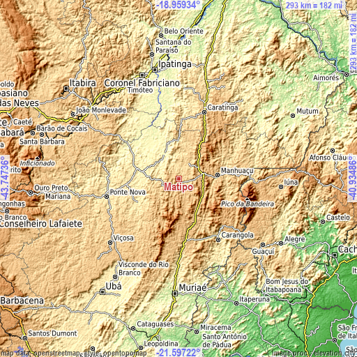
These maps also provides idea of topography and contour of this city, they are displayed at different zoom levels. More info about maps, scale and edge coordinates you can find below images.
| \ | Map #1 | Map #2 | Topo.Map |
| Scale [m] | 564..1088 m | 550..1220 m | × |
| Scale [ft] | 1850..3570 ft | 1804..4003 ft | × |
| Average | 706 m = 2316 ft | 723.6 m = 2374 ft | × |
| Width | 9.17 km = 5.7 mi | 18.33 km = 11.4 mi | 293.3 km = 182.2 mi |
| Height | 9.17 km = 5.7 mi | 18.33 km = 11.4 mi | 293.3 km = 182.2 mi |
| ↑Max Latitude | -20.242664° | -20.201428° | -18.95934° |
| Latitude at center | -20.28389° | -20.28389° | -20.28389° |
| ↓Min Latitude | -20.325105° | -20.366308° | -21.59722° |
| ← Min Longitude | -42.385055° | -42.429001° | -43.74736° |
| Longitude center | -42.34111° | -42.34111° | -42.34111° |
| →Max Longitude | -42.297165° | -42.253219° | -40.93486° |
Nearby cities:
Cities around Matipó sort by population:
• Viçosa elevation 656 m
76.8 km,  227°
227°
• Caratinga 586 m
58.9 km,  21°
21°
• Manhuaçu 641 m
32.2 km,  84°
84°
• Ponte Nova 438 m
61 km,  256°
256°
• Carangola 416 m
59.6 km,  146°
146°
• Lajinha 491 m
76.4 km, 78°
• Manhumirim 603 m
40.8 km,  101°
101°
• Espera Feliz 767 m
60.8 km,  132°
132°
• Bom Jesus do Galho 508 m
50.7 km,  2°
2°
• Alvinópolis 602 m
76.4 km,  284°
284°
• Rio Casca 336 m
32.9 km, 281°
• Irupi 747 m
73.3 km, 95°
Multilingual:
 En español:
Matipó elevación 621 m.
 En France:
Matipó élévation 621 m.


Sources and notes:
- [note 1] Map square and city borders are not equal. Map elevation data is calculated only from area inside that square.
- [src 1] Elevation data from geonames database provided with same terms of usage.
- [src 2] The elevation map of Matipó is generated using elevation data from NASA's 3 arcsec (90m) resolution SRTM data.
- [src 3] Base (background) map © OpenStreetMap contributors tiles are generated by Geofabrik and OpenTopoMap.
Copyright & License:
This Matipó Elevation Map is licensed under CC BY-SA. You may reuse any part from this page, if you give a proper credit by linking to this URL:
 More info on terms of use page.