Medeiros Neto elevation
Medeiros Neto (Bahia), Brazil elevation is 150 meters and Medeiros Neto elevation in feet is 492 ft above sea level [src 1]. Medeiros Neto is a populated place (feature code) with elevation that is 232 meters (761 ft) smaller than average city elevation in Brazil.
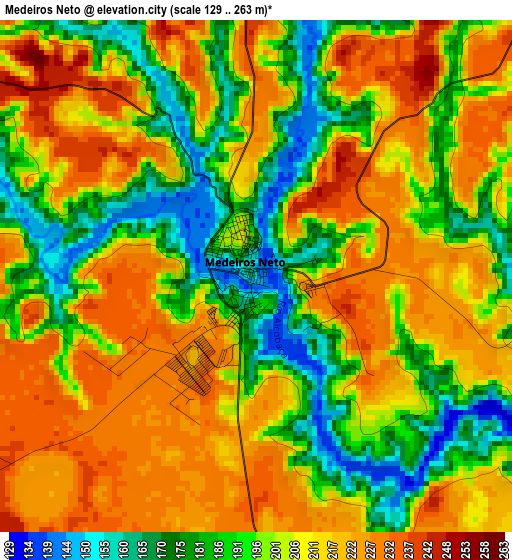
Below is the Elevation map of Medeiros Neto, which displays elevation range with different colors. Scale of the first map is from 129 to 263 m (423 to 863 ft) with average elevation of 204.3 meters (=670 ft) [note 1]
These maps also provides idea of topography and contour of this city, they are displayed at different zoom levels. More info about maps, scale and edge coordinates you can find below images.
| \ | Map #1 | Map #2 | Topo.Map |
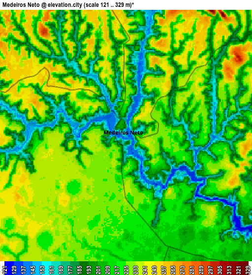
| Scale [m] | 129..263 m | 121..329 m | × |
| Scale [ft] | 423..863 ft | 397..1079 ft | × |
| Average | 204.3 m = 670 ft | 214.5 m = 704 ft | × |
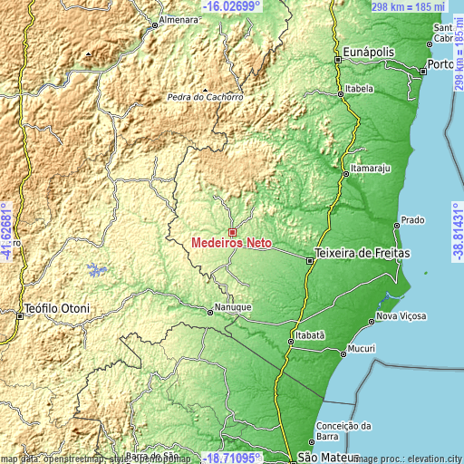
| Width | 9.33 km = 5.8 mi | 18.65 km = 11.6 mi | 298.4 km = 185.4 mi |
| Height | 9.33 km = 5.8 mi | 18.65 km = 11.6 mi | 298.5 km = 185.5 mi |
| ↑Max Latitude | -17.331945° | -17.28999° | -16.02699° |
| Latitude at center | -17.37389° | -17.37389° | -17.37389° |
| ↓Min Latitude | -17.415826° | -17.457752° | -18.71095° |
| ← Min Longitude | -40.264505° | -40.308451° | -41.62681° |
| Longitude center | -40.22056° | -40.22056° | -40.22056° |
| →Max Longitude | -40.176615° | -40.132669° | -38.81431° |
Nearby cities:
Cities around Medeiros Neto sort by population:
• Itamaraju elevation 89 m
82.1 km,  63°
63°
• Nanuque 108 m
53.6 km,  195°
195°
• Mucuri 7 m
106.3 km,  138°
138°
• Posto da Mata 93 m
69 km,  145°
145°
• Prado 11 m
106.2 km,  88°
88°
• Itanhém 189 m
25.8 km,  333°
333°
• Carlos Chagas 206 m
68.5 km,  237°
237°
• Montanha 191 m
85.1 km,  190°
190°
• Águas Formosas 260 m
82.6 km,  293°
293°
• Mucurici 223 m
85.9 km, 201°
• Guaratinga 171 m
99.3 km,  28°
28°
• Teixeira de Freitas 118 m
53.8 km,  109°
109°
Multilingual:
 En español:
Medeiros Neto elevación 150 m.
 En France:
Medeiros Neto élévation 150 m.
 Auf Deutsch:
Medeiros Neto höhe über dem Meeresspiegel ist 150 m.

Sources and notes:
- [note 1] Map square and city borders are not equal. Map elevation data is calculated only from area inside that square.
- [src 1] Elevation data from geonames database provided with same terms of usage.
- [src 2] The elevation map of Medeiros Neto is generated using elevation data from NASA's 3 arcsec (90m) resolution SRTM data.
- [src 3] Base (background) map © OpenStreetMap contributors tiles are generated by Geofabrik and OpenTopoMap.
Copyright & License:
This Medeiros Neto Elevation Map is licensed under CC BY-SA. You may reuse any part from this page, if you give a proper credit by linking to this URL:
 More info on terms of use page.