Prado elevation
Prado (Bahia), Brazil elevation is 11 meters and Prado elevation in feet is 36 ft above sea level [src 1]. Prado is a populated place (feature code) with elevation that is 371 meters (1217 ft) smaller than average city elevation in Brazil.
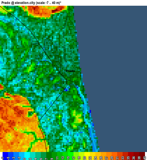
Below is the Elevation map of Prado, which displays elevation range with different colors. Scale of the first map is from -7 to 40 m (-23 to 131 ft) with average elevation of 10.7 meters (=35 ft) [note 1]
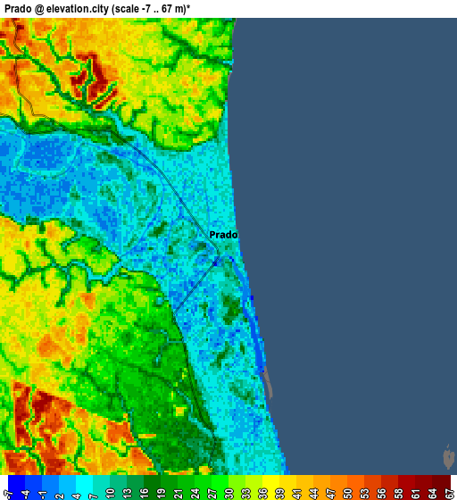
These maps also provides idea of topography and contour of this city, they are displayed at different zoom levels. More info about maps, scale and edge coordinates you can find below images.
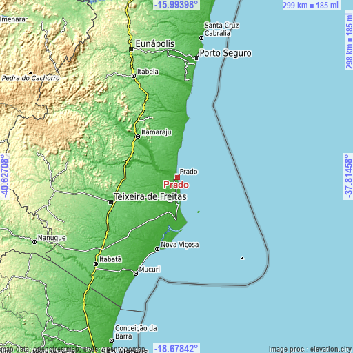
| \ | Map #1 | Map #2 | Topo.Map |
| Scale [m] | -7..40 m | -7..67 m | × |
| Scale [ft] | -23..131 ft | -23..220 ft | × |
| Average | 10.7 m = 35 ft | 22.8 m = 75 ft | × |
| Width | 9.33 km = 5.8 mi | 18.66 km = 11.6 mi | 298.5 km = 185.5 mi |
| Height | 9.33 km = 5.8 mi | 18.66 km = 11.6 mi | 298.5 km = 185.5 mi |
| ↑Max Latitude | -17.299157° | -17.257195° | -15.99398° |
| Latitude at center | -17.34111° | -17.34111° | -17.34111° |
| ↓Min Latitude | -17.383053° | -17.424987° | -18.67842° |
| ← Min Longitude | -39.264775° | -39.308721° | -40.62708° |
| Longitude center | -39.22083° | -39.22083° | -39.22083° |
| →Max Longitude | -39.176885° | -39.132939° | -37.81458° |
Nearby cities:
Cities around Prado sort by population:
• Porto Seguro elevation 4 m
100.5 km,  9°
9°
• Eunápolis 173 m
113.8 km,  340°
340°
• Itamaraju 89 m
47 km,  315°
315°
• Nanuque 108 m
132.2 km,  245°
245°
• Mucuri 7 m
89.9 km,  202°
202°
• Posto da Mata 93 m
90.7 km,  227°
227°
• Nova Viçosa 8 m
63.3 km,  194°
194°
• Santa Cruz Cabrália 43 m
120 km, 10°
• Medeiros Neto 150 m
106.2 km,  268°
268°
• Itanhém 189 m
119.4 km,  279°
279°
• Guaratinga 171 m
103 km, 324°
• Teixeira de Freitas 118 m
59.3 km, 248°
Multilingual:
 En español:
Prado elevación 11 m.
 En France:
Prado élévation 11 m.


Sources and notes:
- [note 1] Map square and city borders are not equal. Map elevation data is calculated only from area inside that square.
- [src 1] Elevation data from geonames database provided with same terms of usage.
- [src 2] The elevation map of Prado is generated using elevation data from NASA's 3 arcsec (90m) resolution SRTM data.
- [src 3] Base (background) map © OpenStreetMap contributors tiles are generated by Geofabrik and OpenTopoMap.
Copyright & License:
This Prado Elevation Map is licensed under CC BY-SA. You may reuse any part from this page, if you give a proper credit by linking to this URL:
 More info on terms of use page.