Ubatuba elevation
Ubatuba (São Paulo), Brazil elevation is 6 meters and Ubatuba elevation in feet is 20 ft above sea level [src 1]. Ubatuba is a seat of a second-order administrative division (feature code) with elevation that is 376 meters (1234 ft) smaller than average city elevation in Brazil.
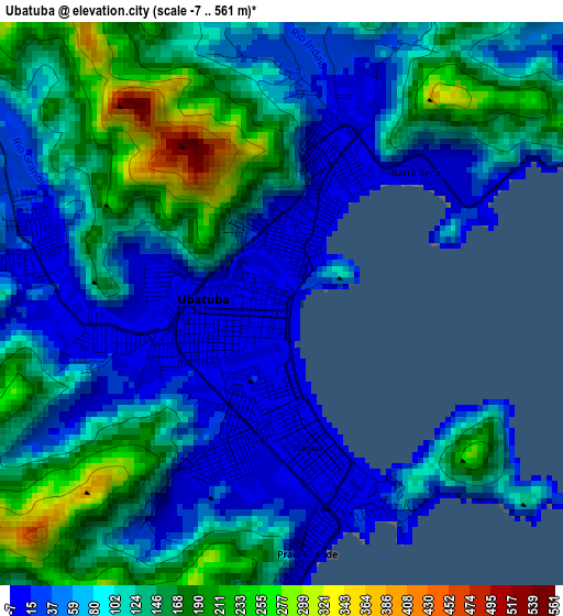
Below is the Elevation map of Ubatuba, which displays elevation range with different colors. Scale of the first map is from -7 to 561 m (-23 to 1841 ft) with average elevation of 103.7 meters (=340 ft) [note 1]
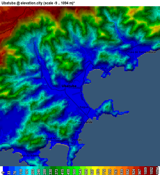
These maps also provides idea of topography and contour of this city, they are displayed at different zoom levels. More info about maps, scale and edge coordinates you can find below images.
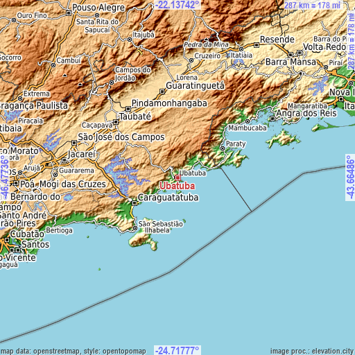
| \ | Map #1 | Map #2 | Topo.Map |
| Scale [m] | -7..561 m | -9..1094 m | × |
| Scale [ft] | -23..1841 ft | -30..3589 ft | × |
| Average | 103.7 m = 340 ft | 265.6 m = 871 ft | × |
| Width | 8.97 km = 5.6 mi | 17.93 km = 11.1 mi | 286.9 km = 178.3 mi |
| Height | 8.97 km = 5.6 mi | 17.93 km = 11.1 mi | 286.9 km = 178.3 mi |
| ↑Max Latitude | -23.393563° | -23.353224° | -22.13742° |
| Latitude at center | -23.43389° | -23.43389° | -23.43389° |
| ↓Min Latitude | -23.474205° | -23.514507° | -24.71777° |
| ← Min Longitude | -45.115055° | -45.159001° | -46.47736° |
| Longitude center | -45.07111° | -45.07111° | -45.07111° |
| →Max Longitude | -45.027165° | -44.983219° | -43.66486° |
Nearby cities:
Cities around Ubatuba sort by population:
• Taubaté elevation 589 m
67.1 km,  312°
312°
• Pindamonhangaba 562 m
69.3 km,  324°
324°
• Guaratinguetá 545 m
69.8 km,  349°
349°
• Caraguatatuba 2 m
40.6 km,  239°
239°
• Lorena 529 m
78.4 km,  355°
355°
• São Sebastião 6 m
50.1 km,  223°
223°
• Caçapava 564 m
74.8 km,  299°
299°
• Aparecida 593 m
67.2 km, 346°
• Ilhabela 7 m
48.2 km, 217°
• Tremembé 558 m
72 km, 317°
• Paraty 8 m
43.7 km,  56°
56°
• Cunha 953 m
41.6 km,  15°
15°
Multilingual:
 En español:
Ubatuba elevación 6 m.
 En France:
Ubatuba élévation 6 m.


Sources and notes:
- [note 1] Map square and city borders are not equal. Map elevation data is calculated only from area inside that square.
- [src 1] Elevation data from geonames database provided with same terms of usage.
- [src 2] The elevation map of Ubatuba is generated using elevation data from NASA's 3 arcsec (90m) resolution SRTM data.
- [src 3] Base (background) map © OpenStreetMap contributors tiles are generated by Geofabrik and OpenTopoMap.
Copyright & License:
This Ubatuba Elevation Map is licensed under CC BY-SA. You may reuse any part from this page, if you give a proper credit by linking to this URL:
 More info on terms of use page.