Caraguatatuba elevation
Caraguatatuba (São Paulo), Brazil elevation is 2 meters and Caraguatatuba elevation in feet is 7 ft above sea level [src 1]. Caraguatatuba is a seat of a second-order administrative division (feature code) with elevation that is 380 meters (1247 ft) smaller than average city elevation in Brazil.
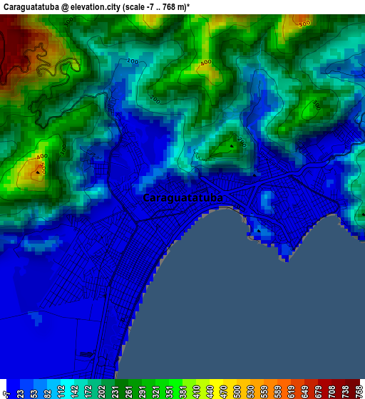
Below is the Elevation map of Caraguatatuba, which displays elevation range with different colors. Scale of the first map is from -7 to 768 m (-23 to 2520 ft) with average elevation of 140.6 meters (=461 ft) [note 1]
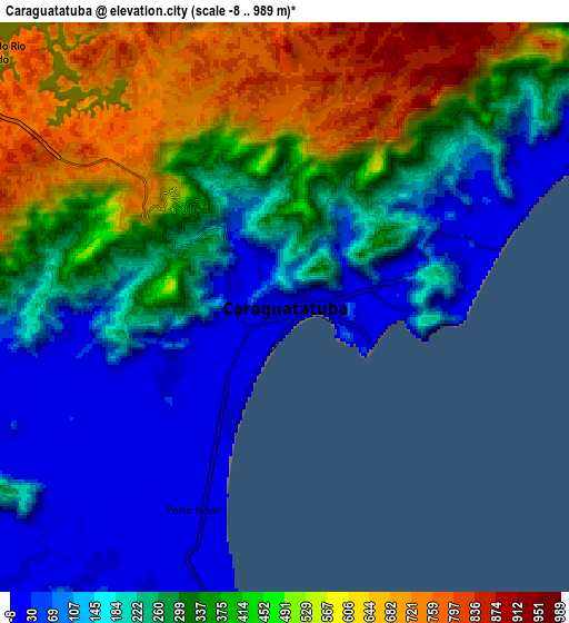
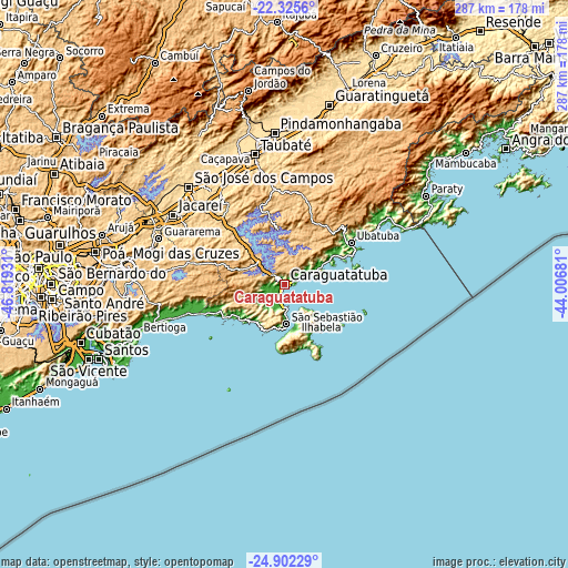
These maps also provides idea of topography and contour of this city, they are displayed at different zoom levels. More info about maps, scale and edge coordinates you can find below images.
| \ | Map #1 | Map #2 | Topo.Map |
| Scale [m] | -7..768 m | -8..989 m | × |
| Scale [ft] | -23..2520 ft | -26..3245 ft | × |
| Average | 140.6 m = 461 ft | 319.6 m = 1049 ft | × |
| Width | 8.95 km = 5.6 mi | 17.91 km = 11.1 mi | 286.5 km = 178 mi |
| Height | 8.95 km = 5.6 mi | 17.91 km = 11.1 mi | 286.5 km = 178 mi |
| ↑Max Latitude | -23.58001° | -23.539728° | -22.3256° |
| Latitude at center | -23.62028° | -23.62028° | -23.62028° |
| ↓Min Latitude | -23.660537° | -23.700782° | -24.90229° |
| ← Min Longitude | -45.457005° | -45.500951° | -46.81931° |
| Longitude center | -45.41306° | -45.41306° | -45.41306° |
| →Max Longitude | -45.369115° | -45.325169° | -44.00681° |
Nearby cities:
Cities around Caraguatatuba sort by population:
• São José dos Campos elevation 596 m
68.9 km,  315°
315°
• Taubaté 589 m
67.6 km,  347°
347°
• Jacareí 574 m
66.4 km,  301°
301°
• Ubatuba 6 m
40.6 km,  59°
59°
• São Sebastião 6 m
15.5 km,  178°
178°
• Caçapava 564 m
65.1 km,  332°
332°
• Ilhabela 7 m
18.4 km,  162°
162°
• Tremembé 558 m
74.9 km, 349°
• Biritiba Mirim 775 m
64 km,  274°
274°
• Guararema 583 m
67.4 km,  289°
289°
• Cunha 953 m
76.3 km,  37°
37°
• Santa Branca 648 m
54.1 km, 297°
Multilingual:
 En español:
Caraguatatuba elevación 2 m.
 En France:
Caraguatatuba élévation 2 m.
 Auf Deutsch:
Caraguatatuba höhe über dem Meeresspiegel ist 2 m.

Sources and notes:
- [note 1] Map square and city borders are not equal. Map elevation data is calculated only from area inside that square.
- [src 1] Elevation data from geonames database provided with same terms of usage.
- [src 2] The elevation map of Caraguatatuba is generated using elevation data from NASA's 3 arcsec (90m) resolution SRTM data.
- [src 3] Base (background) map © OpenStreetMap contributors tiles are generated by Geofabrik and OpenTopoMap.
Copyright & License:
This Caraguatatuba Elevation Map is licensed under CC BY-SA. You may reuse any part from this page, if you give a proper credit by linking to this URL:
 More info on terms of use page.