Guaratinguetá elevation
Guaratinguetá (São Paulo), Brazil elevation is 545 meters and Guaratinguetá elevation in feet is 1788 ft above sea level [src 1]. Guaratinguetá is a populated place (feature code) with elevation that is 163 meters (535 ft) bigger than average city elevation in Brazil.
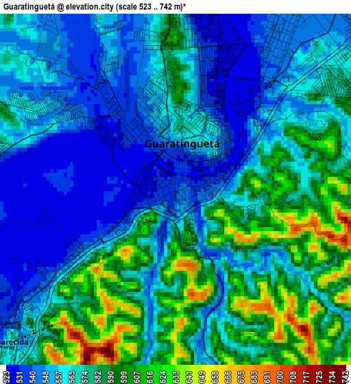
Below is the Elevation map of Guaratinguetá, which displays elevation range with different colors. Scale of the first map is from 523 to 742 m (1716 to 2434 ft) with average elevation of 570.1 meters (=1870 ft) [note 1]
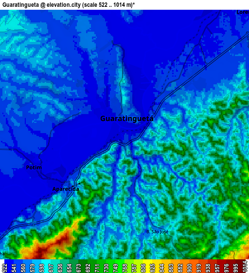
These maps also provides idea of topography and contour of this city, they are displayed at different zoom levels. More info about maps, scale and edge coordinates you can find below images.
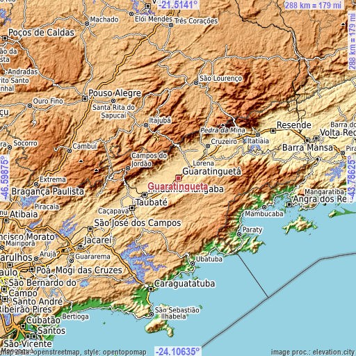
| \ | Map #1 | Map #2 | Topo.Map |
| Scale [m] | 523..742 m | 522..1014 m | × |
| Scale [ft] | 1716..2434 ft | 1713..3327 ft | × |
| Average | 570.1 m = 1870 ft | 589.4 m = 1934 ft | × |
| Width | 9.01 km = 5.6 mi | 18.02 km = 11.2 mi | 288.2 km = 179.1 mi |
| Height | 9.01 km = 5.6 mi | 18.02 km = 11.2 mi | 288.2 km = 179.1 mi |
| ↑Max Latitude | -22.775877° | -22.735353° | -21.5141° |
| Latitude at center | -22.81639° | -22.81639° | -22.81639° |
| ↓Min Latitude | -22.856891° | -22.897379° | -24.10635° |
| ← Min Longitude | -45.236445° | -45.280391° | -46.59875° |
| Longitude center | -45.1925° | -45.1925° | -45.1925° |
| →Max Longitude | -45.148555° | -45.104609° | -43.78625° |
Nearby cities:
Cities around Guaratinguetá sort by population:
• Taubaté elevation 589 m
43.9 km,  237°
237°
• Pindamonhangaba 562 m
30.1 km,  246°
246°
• Itajubá 858 m
51 km,  328°
328°
• Lorena 529 m
11.8 km,  36°
36°
• Caçapava 564 m
61.4 km, 239°
• Cruzeiro 545 m
35.3 km, 40°
• Campos do Jordão 1603 m
41.8 km,  281°
281°
• Aparecida 593 m
5.1 km,  228°
228°
• Tremembé 558 m
39.8 km, 246°
• Piquete 642 m
22.6 km,  4°
4°
• Passa Quatro 924 m
52.7 km,  26°
26°
• Cunha 953 m
37.3 km,  140°
140°
Multilingual:
 En español:
Guaratinguetá elevación 545 m.
 En France:
Guaratinguetá élévation 545 m.
 Auf Deutsch:
Guaratinguetá höhe über dem Meeresspiegel ist 545 m.

Sources and notes:
- [note 1] Map square and city borders are not equal. Map elevation data is calculated only from area inside that square.
- [src 1] Elevation data from geonames database provided with same terms of usage.
- [src 2] The elevation map of Guaratinguetá is generated using elevation data from NASA's 3 arcsec (90m) resolution SRTM data.
- [src 3] Base (background) map © OpenStreetMap contributors tiles are generated by Geofabrik and OpenTopoMap.
Copyright & License:
This Guaratinguetá Elevation Map is licensed under CC BY-SA. You may reuse any part from this page, if you give a proper credit by linking to this URL:
 More info on terms of use page.