Valente elevation
Valente (Bahia), Brazil elevation is 357 meters and Valente elevation in feet is 1171 ft above sea level [src 1]. Valente is a populated place (feature code) with elevation that is 25 meters (82 ft) smaller than average city elevation in Brazil.
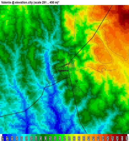
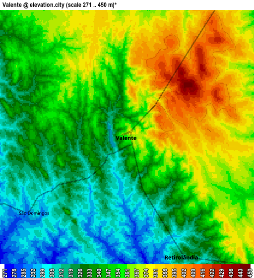
Below is the Elevation map of Valente, which displays elevation range with different colors. Scale of the first map is from 291 to 450 m (955 to 1476 ft) with average elevation of 351.1 meters (=1152 ft) [note 1]
These maps also provides idea of topography and contour of this city, they are displayed at different zoom levels. More info about maps, scale and edge coordinates you can find below images.
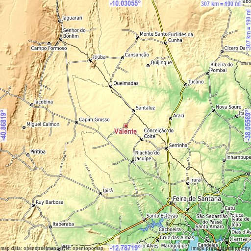
| \ | Map #1 | Map #2 | Topo.Map |
| Scale [m] | 291..450 m | 271..450 m | × |
| Scale [ft] | 955..1476 ft | 889..1476 ft | × |
| Average | 351.1 m = 1152 ft | 348.8 m = 1144 ft | × |
| Width | 9.58 km = 6 mi | 19.16 km = 11.9 mi | 306.5 km = 190.4 mi |
| Height | 9.58 km = 6 mi | 19.16 km = 11.9 mi | 306.5 km = 190.4 mi |
| ↑Max Latitude | -11.36914° | -11.326054° | -10.03055° |
| Latitude at center | -11.41222° | -11.41222° | -11.41222° |
| ↓Min Latitude | -11.455293° | -11.49836° | -12.78719° |
| ← Min Longitude | -39.505885° | -39.549831° | -40.86819° |
| Longitude center | -39.46194° | -39.46194° | -39.46194° |
| →Max Longitude | -39.417995° | -39.374049° | -38.05569° |
Nearby cities:
Cities around Valente sort by population:
• Serrinha elevation 368 m
56.9 km,  119°
119°
• Conceição do Coité 431 m
25.8 km,  130°
130°
• Tucano 222 m
88.9 km,  55°
55°
• Ipirá 331 m
88.2 km,  199°
199°
• Santaluz 361 m
19.8 km,  28°
28°
• Capim Grosso 416 m
60.1 km,  273°
273°
• Riachão do Jacuípe 217 m
44.7 km,  169°
169°
• Araci 257 m
54.7 km,  80°
80°
• Mairi 471 m
81.9 km,  246°
246°
• Queimadas 291 m
51.5 km,  339°
339°
• Anguera 238 m
85.4 km,  164°
164°
• Quijingue 358 m
78.4 km,  20°
20°
Multilingual:
 En español:
Valente elevación 357 m.
 En France:
Valente élévation 357 m.


Sources and notes:
- [note 1] Map square and city borders are not equal. Map elevation data is calculated only from area inside that square.
- [src 1] Elevation data from geonames database provided with same terms of usage.
- [src 2] The elevation map of Valente is generated using elevation data from NASA's 3 arcsec (90m) resolution SRTM data.
- [src 3] Base (background) map © OpenStreetMap contributors tiles are generated by Geofabrik and OpenTopoMap.
Copyright & License:
This Valente Elevation Map is licensed under CC BY-SA. You may reuse any part from this page, if you give a proper credit by linking to this URL:
 More info on terms of use page.