Capim Grosso elevation
Capim Grosso (Bahia), Brazil elevation is 416 meters and Capim Grosso elevation in feet is 1365 ft above sea level [src 1]. Capim Grosso is a populated place (feature code) with elevation that is 34 meters (112 ft) bigger than average city elevation in Brazil.
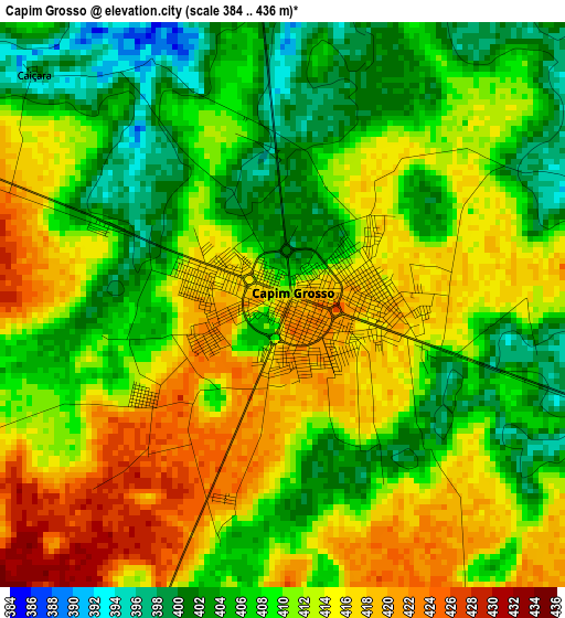
Below is the Elevation map of Capim Grosso, which displays elevation range with different colors. Scale of the first map is from 384 to 436 m (1260 to 1430 ft) with average elevation of 410.3 meters (=1346 ft) [note 1]
These maps also provides idea of topography and contour of this city, they are displayed at different zoom levels. More info about maps, scale and edge coordinates you can find below images.
| \ | Map #1 | Map #2 | Topo.Map |
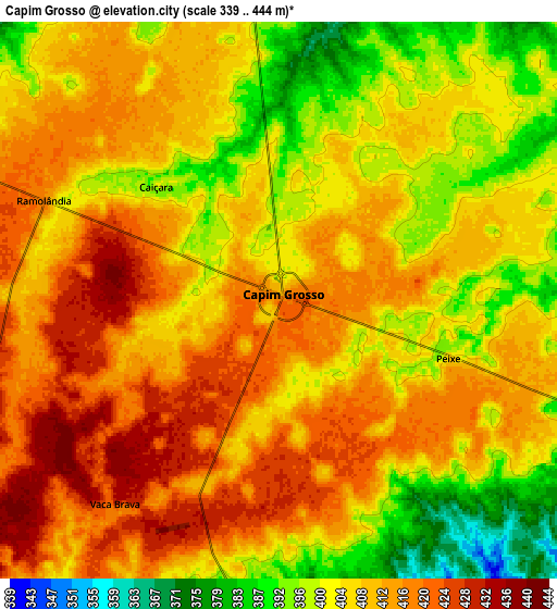
| Scale [m] | 384..436 m | 339..444 m | × |
| Scale [ft] | 1260..1430 ft | 1112..1457 ft | × |
| Average | 410.3 m = 1346 ft | 407.4 m = 1337 ft | × |
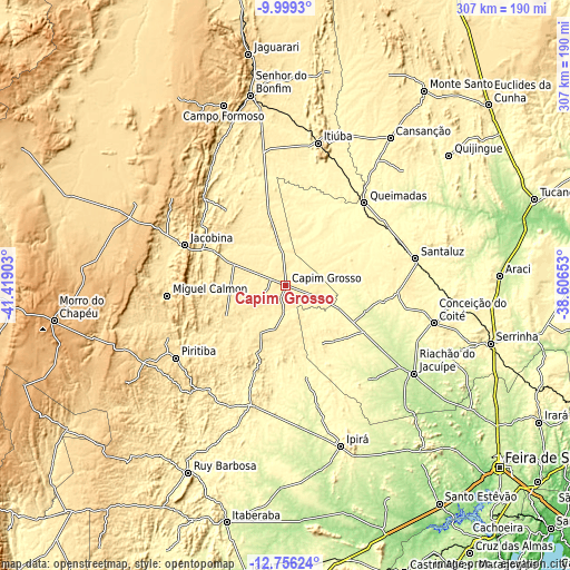
| Width | 9.58 km = 6 mi | 19.16 km = 11.9 mi | 306.5 km = 190.4 mi |
| Height | 9.58 km = 6 mi | 19.16 km = 11.9 mi | 306.6 km = 190.5 mi |
| ↑Max Latitude | -11.338026° | -11.294935° | -9.9993° |
| Latitude at center | -11.38111° | -11.38111° | -11.38111° |
| ↓Min Latitude | -11.424188° | -11.467259° | -12.75624° |
| ← Min Longitude | -40.056725° | -40.100671° | -41.41903° |
| Longitude center | -40.01278° | -40.01278° | -40.01278° |
| →Max Longitude | -39.968835° | -39.924889° | -38.60653° |
Nearby cities:
Cities around Capim Grosso sort by population:
• Jacobina elevation 476 m
59 km,  292°
292°
• Conceição do Coité 431 m
82.1 km,  104°
104°
• Santaluz 361 m
70.9 km,  78°
78°
• Pindobaçu 435 m
80.6 km,  331°
331°
• Piritiba 542 m
70.7 km,  236°
236°
• Miguel Calmon 543 m
63.7 km,  265°
265°
• Mairi 471 m
39.6 km,  201°
201°
• Valente 357 m
60.1 km,  93°
93°
• Mundo Novo 522 m
73 km,  223°
223°
• Queimadas 291 m
61.5 km,  43°
43°
• Baixa Grande 367 m
66.5 km,  194°
194°
• Ponto Novo 370 m
59.1 km,  347°
347°
Multilingual:
 En español:
Capim Grosso elevación 416 m.
 En France:
Capim Grosso élévation 416 m.
 Auf Deutsch:
Capim Grosso höhe über dem Meeresspiegel ist 416 m.

Sources and notes:
- [note 1] Map square and city borders are not equal. Map elevation data is calculated only from area inside that square.
- [src 1] Elevation data from geonames database provided with same terms of usage.
- [src 2] The elevation map of Capim Grosso is generated using elevation data from NASA's 3 arcsec (90m) resolution SRTM data.
- [src 3] Base (background) map © OpenStreetMap contributors tiles are generated by Geofabrik and OpenTopoMap.
Copyright & License:
This Capim Grosso Elevation Map is licensed under CC BY-SA. You may reuse any part from this page, if you give a proper credit by linking to this URL:
 More info on terms of use page.