Anguera elevation
Anguera (Bahia), Brazil elevation is 238 meters and Anguera elevation in feet is 781 ft above sea level [src 1]. Anguera is a populated place (feature code) with elevation that is 144 meters (472 ft) smaller than average city elevation in Brazil.
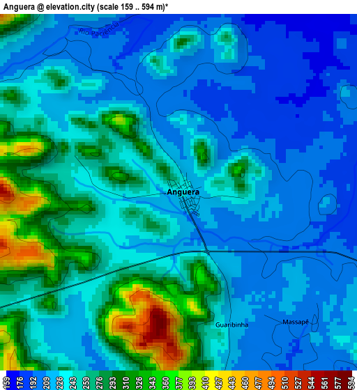
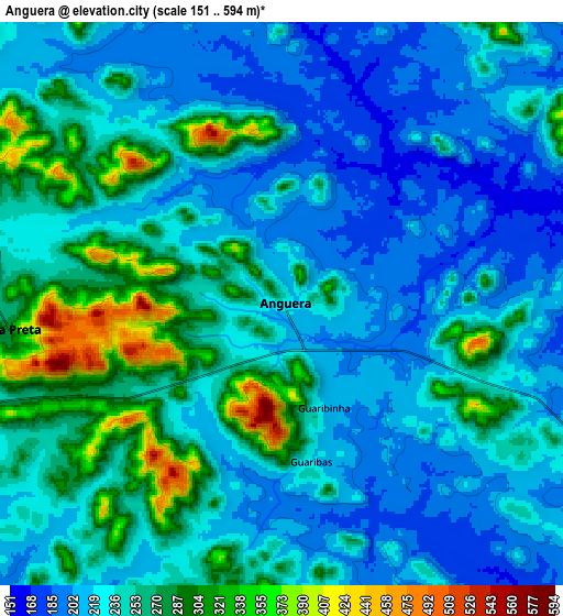
Below is the Elevation map of Anguera, which displays elevation range with different colors. Scale of the first map is from 159 to 594 m (522 to 1949 ft) with average elevation of 243.8 meters (=800 ft) [note 1]
These maps also provides idea of topography and contour of this city, they are displayed at different zoom levels. More info about maps, scale and edge coordinates you can find below images.
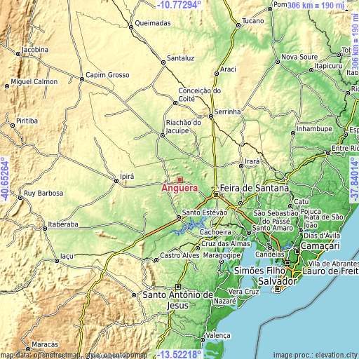
| \ | Map #1 | Map #2 | Topo.Map |
| Scale [m] | 159..594 m | 151..594 m | × |
| Scale [ft] | 522..1949 ft | 495..1949 ft | × |
| Average | 243.8 m = 800 ft | 242.5 m = 796 ft | × |
| Width | 9.55 km = 5.9 mi | 19.11 km = 11.9 mi | 305.7 km = 190 mi |
| Height | 9.55 km = 5.9 mi | 19.11 km = 11.9 mi | 305.7 km = 190 mi |
| ↑Max Latitude | -12.108146° | -12.065175° | -10.77294° |
| Latitude at center | -12.15111° | -12.15111° | -12.15111° |
| ↓Min Latitude | -12.194067° | -12.237018° | -13.52218° |
| ← Min Longitude | -39.290335° | -39.334281° | -40.65264° |
| Longitude center | -39.24639° | -39.24639° | -39.24639° |
| →Max Longitude | -39.202445° | -39.158499° | -37.84014° |
Nearby cities:
Cities around Anguera sort by population:
• Feira de Santana elevation 223 m
33 km,  112°
112°
• Serrinha 368 m
60.1 km,  25°
25°
• Cruz das Almas 224 m
59.8 km,  164°
164°
• Santo Estêvão 242 m
31 km,  181°
181°
• Ipirá 331 m
53.4 km,  269°
269°
• Conceição do Jacuípe 212 m
55.3 km, 109°
• Riachão do Jacuípe 217 m
41.2 km,  338°
338°
• Cachoeira 8 m
58.6 km,  148°
148°
• Conceição da Feira 219 m
47.7 km, 145°
• São Gonçalo dos Campos 228 m
43.7 km,  135°
135°
• Irará 274 m
53.4 km,  77°
77°
• Coração de Maria 216 m
54.7 km,  99°
99°
Multilingual:
 En español:
Anguera elevación 238 m.
 En France:
Anguera élévation 238 m.


Sources and notes:
- [note 1] Map square and city borders are not equal. Map elevation data is calculated only from area inside that square.
- [src 1] Elevation data from geonames database provided with same terms of usage.
- [src 2] The elevation map of Anguera is generated using elevation data from NASA's 3 arcsec (90m) resolution SRTM data.
- [src 3] Base (background) map © OpenStreetMap contributors tiles are generated by Geofabrik and OpenTopoMap.
Copyright & License:
This Anguera Elevation Map is licensed under CC BY-SA. You may reuse any part from this page, if you give a proper credit by linking to this URL:
 More info on terms of use page.