Boqueirão elevation
Boqueirão (Paraíba), Brazil elevation is 367 meters and Boqueirão elevation in feet is 1204 ft above sea level [src 1]. Boqueirão is a populated place (feature code) with elevation that is 15 meters (49 ft) smaller than average city elevation in Brazil.
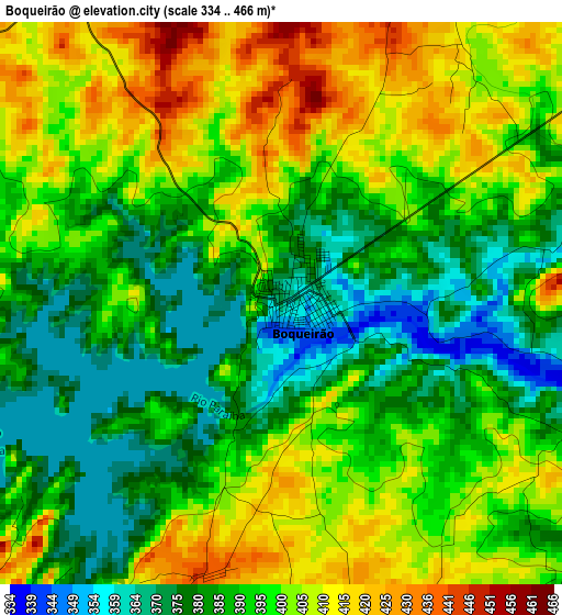
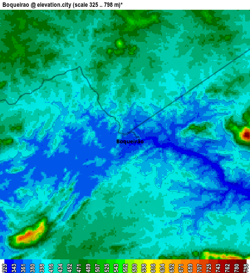
Below is the Elevation map of Boqueirão, which displays elevation range with different colors. Scale of the first map is from 334 to 466 m (1096 to 1529 ft) with average elevation of 394.6 meters (=1295 ft) [note 1]
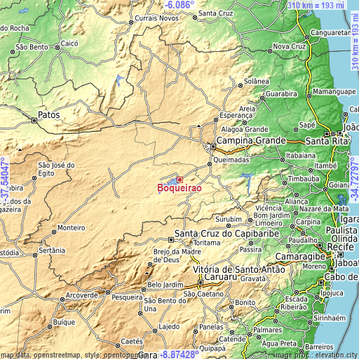
These maps also provides idea of topography and contour of this city, they are displayed at different zoom levels. More info about maps, scale and edge coordinates you can find below images.
| \ | Map #1 | Map #2 | Topo.Map |
| Scale [m] | 334..466 m | 325..798 m | × |
| Scale [ft] | 1096..1529 ft | 1066..2618 ft | × |
| Average | 394.6 m = 1295 ft | 421.1 m = 1382 ft | × |
| Width | 9.69 km = 6 mi | 19.38 km = 12 mi | 310 km = 192.6 mi |
| Height | 9.69 km = 6 mi | 19.38 km = 12 mi | 310.1 km = 192.7 mi |
| ↑Max Latitude | -7.438797° | -7.395219° | -6.086° |
| Latitude at center | -7.48237° | -7.48237° | -7.48237° |
| ↓Min Latitude | -7.525939° | -7.569503° | -8.87428° |
| ← Min Longitude | -36.178165° | -36.222111° | -37.54047° |
| Longitude center | -36.13422° | -36.13422° | -36.13422° |
| →Max Longitude | -36.090275° | -36.046329° | -34.72797° |
Nearby cities:
Cities around Boqueirão sort by population:
• Campina Grande elevation 508 m
39.5 km,  44°
44°
• Santa Cruz do Capibaribe 445 m
53.4 km,  188°
188°
• Taquaritinga do Norte 771 m
47.8 km,  168°
168°
• Lagoa Seca 631 m
46.4 km, 41°
• Soledade 526 m
53.6 km,  331°
331°
• Pocinhos 633 m
45.8 km,  10°
10°
• Aroeiras 341 m
47.6 km,  98°
98°
• Fagundes 468 m
42.1 km,  70°
70°
• Itatuba 115 m
57 km,  77°
77°
• Umbuzeiro 527 m
57 km,  114°
114°
• Puxinanã 671 m
40.5 km,  28°
28°
• Massaranduba 371 m
49.3 km,  50°
50°
Multilingual:
 En español:
Boqueirão elevación 367 m.
 En France:
Boqueirão élévation 367 m.
 Auf Deutsch:
Boqueirão höhe über dem Meeresspiegel ist 367 m.

Sources and notes:
- [note 1] Map square and city borders are not equal. Map elevation data is calculated only from area inside that square.
- [src 1] Elevation data from geonames database provided with same terms of usage.
- [src 2] The elevation map of Boqueirão is generated using elevation data from NASA's 3 arcsec (90m) resolution SRTM data.
- [src 3] Base (background) map © OpenStreetMap contributors tiles are generated by Geofabrik and OpenTopoMap.
Copyright & License:
This Boqueirão Elevation Map is licensed under CC BY-SA. You may reuse any part from this page, if you give a proper credit by linking to this URL:
 More info on terms of use page.