Taquaritinga do Norte elevation
Taquaritinga do Norte (Pernambuco), Brazil elevation is 771 meters and Taquaritinga do Norte elevation in feet is 2530 ft above sea level [src 1]. Taquaritinga do Norte is a populated place (feature code) with elevation that is 389 meters (1276 ft) bigger than average city elevation in Brazil.
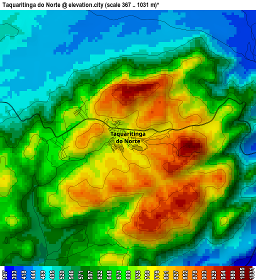
Below is the Elevation map of Taquaritinga do Norte, which displays elevation range with different colors. Scale of the first map is from 367 to 1031 m (1204 to 3383 ft) with average elevation of 636.9 meters (=2090 ft) [note 1]
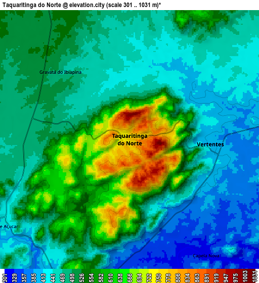
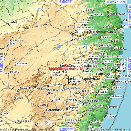
These maps also provides idea of topography and contour of this city, they are displayed at different zoom levels. More info about maps, scale and edge coordinates you can find below images.
| \ | Map #1 | Map #2 | Topo.Map |
| Scale [m] | 367..1031 m | 301..1031 m | × |
| Scale [ft] | 1204..3383 ft | 988..3383 ft | × |
| Average | 636.9 m = 2090 ft | 502.8 m = 1650 ft | × |
| Width | 9.68 km = 6 mi | 19.36 km = 12 mi | 309.7 km = 192.4 mi |
| Height | 9.68 km = 6 mi | 19.36 km = 12 mi | 309.7 km = 192.4 mi |
| ↑Max Latitude | -7.85953° | -7.815995° | -6.50795° |
| Latitude at center | -7.90306° | -7.90306° | -7.90306° |
| ↓Min Latitude | -7.946586° | -7.990107° | -9.29347° |
| ← Min Longitude | -36.088115° | -36.132061° | -37.45042° |
| Longitude center | -36.04417° | -36.04417° | -36.04417° |
| →Max Longitude | -36.000225° | -35.956279° | -34.63792° |
Nearby cities:
Cities around Taquaritinga do Norte sort by population:
• Caruaru elevation 568 m
42.9 km,  169°
169°
• Santa Cruz do Capibaribe 445 m
18.7 km,  251°
251°
• Bezerros 501 m
45.7 km,  143°
143°
• Surubim 377 m
32.8 km,  76°
76°
• Brejo da Madre de Deus 654 m
45 km,  233°
233°
• Toritama 356 m
11.6 km,  186°
186°
• Bom Jardim 306 m
51.7 km, 76°
• Boqueirão 367 m
47.8 km,  348°
348°
• João Alfredo 345 m
50.5 km, 84°
• Cumaru 362 m
39.9 km,  106°
106°
• Orobó 392 m
51.8 km,  70°
70°
• Umbuzeiro 527 m
47.9 km,  61°
61°
Multilingual:
 En español:
Taquaritinga do Norte elevación 771 m.
 En France:
Taquaritinga do Norte élévation 771 m.
 Auf Deutsch:
Taquaritinga do Norte höhe über dem Meeresspiegel ist 771 m.
 На русском:
Taquaritinga do Norte высота над уровнем моря 771 м
Sources and notes:
- [note 1] Map square and city borders are not equal. Map elevation data is calculated only from area inside that square.
- [src 1] Elevation data from geonames database provided with same terms of usage.
- [src 2] The elevation map of Taquaritinga do Norte is generated using elevation data from NASA's 3 arcsec (90m) resolution SRTM data.
- [src 3] Base (background) map © OpenStreetMap contributors tiles are generated by Geofabrik and OpenTopoMap.
Copyright & License:
This Taquaritinga do Norte Elevation Map is licensed under CC BY-SA. You may reuse any part from this page, if you give a proper credit by linking to this URL:
 More info on terms of use page.