Fagundes elevation
Fagundes (Paraíba), Brazil elevation is 468 meters and Fagundes elevation in feet is 1535 ft above sea level [src 1]. Fagundes is a populated place (feature code) with elevation that is 86 meters (282 ft) bigger than average city elevation in Brazil.
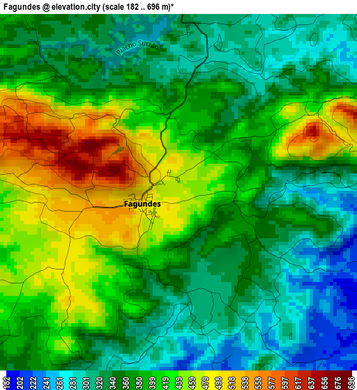
Below is the Elevation map of Fagundes, which displays elevation range with different colors. Scale of the first map is from 182 to 696 m (597 to 2283 ft) with average elevation of 382.6 meters (=1255 ft) [note 1]
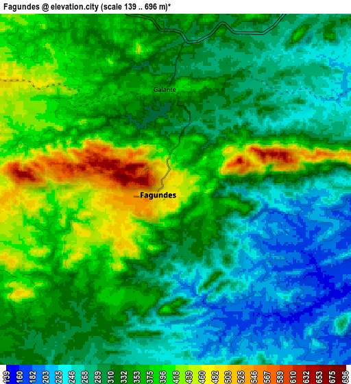
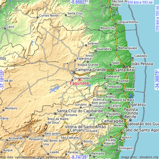
These maps also provides idea of topography and contour of this city, they are displayed at different zoom levels. More info about maps, scale and edge coordinates you can find below images.
| \ | Map #1 | Map #2 | Topo.Map |
| Scale [m] | 182..696 m | 139..696 m | × |
| Scale [ft] | 597..2283 ft | 456..2283 ft | × |
| Average | 382.6 m = 1255 ft | 333.1 m = 1093 ft | × |
| Width | 9.69 km = 6 mi | 19.38 km = 12 mi | 310.1 km = 192.7 mi |
| Height | 9.69 km = 6 mi | 19.38 km = 12 mi | 310.1 km = 192.7 mi |
| ↑Max Latitude | -7.311414° | -7.267824° | -5.95827° |
| Latitude at center | -7.355° | -7.355° | -7.355° |
| ↓Min Latitude | -7.398582° | -7.442159° | -8.74735° |
| ← Min Longitude | -35.818945° | -35.862891° | -37.18125° |
| Longitude center | -35.775° | -35.775° | -35.775° |
| →Max Longitude | -35.731055° | -35.687109° | -34.36875° |
Nearby cities:
Cities around Fagundes sort by population:
• Campina Grande elevation 508 m
18.1 km,  319°
319°
• Esperança 610 m
36.9 km,  345°
345°
• Alagoa Grande 334 m
27.1 km,  36°
36°
• Alagoa Nova 440 m
31.7 km,  3°
3°
• Ingá 155 m
20.5 km,  66°
66°
• Lagoa Seca 631 m
22.2 km,  337°
337°
• Aroeiras 341 m
22.4 km,  160°
160°
• Itatuba 115 m
16.3 km,  97°
97°
• Mogeiro 119 m
33.2 km,  79°
79°
• Salgado de São Félix 64 m
36.9 km,  90°
90°
• Puxinanã 671 m
29.7 km, 316°
• Massaranduba 371 m
17.3 km, 354°
Multilingual:
 En español:
Fagundes elevación 468 m.
 En France:
Fagundes élévation 468 m.
 Auf Deutsch:
Fagundes höhe über dem Meeresspiegel ist 468 m.

Sources and notes:
- [note 1] Map square and city borders are not equal. Map elevation data is calculated only from area inside that square.
- [src 1] Elevation data from geonames database provided with same terms of usage.
- [src 2] The elevation map of Fagundes is generated using elevation data from NASA's 3 arcsec (90m) resolution SRTM data.
- [src 3] Base (background) map © OpenStreetMap contributors tiles are generated by Geofabrik and OpenTopoMap.
Copyright & License:
This Fagundes Elevation Map is licensed under CC BY-SA. You may reuse any part from this page, if you give a proper credit by linking to this URL:
 More info on terms of use page.