Curaçá elevation
Curaçá (Bahia), Brazil elevation is 359 meters and Curaçá elevation in feet is 1178 ft above sea level [src 1]. Curaçá is a populated place (feature code) with elevation that is 23 meters (75 ft) smaller than average city elevation in Brazil.
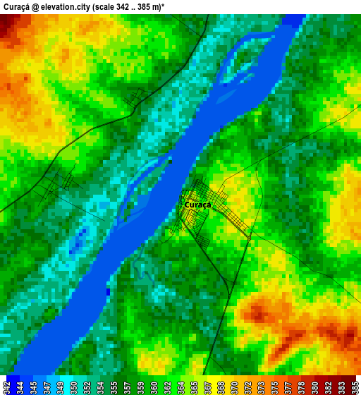
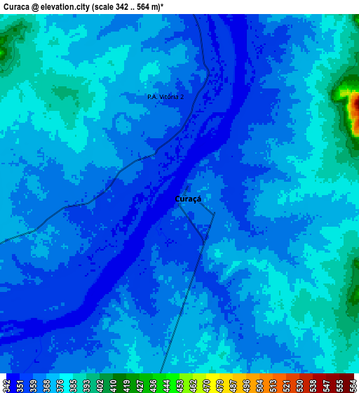
Below is the Elevation map of Curaçá, which displays elevation range with different colors. Scale of the first map is from 342 to 385 m (1122 to 1263 ft) with average elevation of 358.7 meters (=1177 ft) [note 1]
These maps also provides idea of topography and contour of this city, they are displayed at different zoom levels. More info about maps, scale and edge coordinates you can find below images.
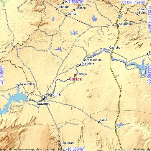
| \ | Map #1 | Map #2 | Topo.Map |
| Scale [m] | 342..385 m | 342..564 m | × |
| Scale [ft] | 1122..1263 ft | 1122..1850 ft | × |
| Average | 358.7 m = 1177 ft | 368.6 m = 1209 ft | × |
| Width | 9.65 km = 6 mi | 19.31 km = 12 mi | 308.8 km = 191.9 mi |
| Height | 9.65 km = 6 mi | 19.3 km = 12 mi | 308.9 km = 191.9 mi |
| ↑Max Latitude | -8.946872° | -8.903459° | -7.59878° |
| Latitude at center | -8.99028° | -8.99028° | -8.99028° |
| ↓Min Latitude | -9.033683° | -9.07708° | -10.37646° |
| ← Min Longitude | -39.953385° | -39.997331° | -41.31569° |
| Longitude center | -39.90944° | -39.90944° | -39.90944° |
| →Max Longitude | -39.865495° | -39.821549° | -38.50319° |
Nearby cities:
Cities around Curaçá sort by population:
• Petrolina elevation 383 m
79.2 km,  235°
235°
• Salgueiro 420 m
133.9 km,  40°
40°
• Ouricuri 451 m
124.6 km,  351°
351°
• Jaguarari 660 m
145.1 km,  192°
192°
• Trindade 523 m
142.2 km,  343°
343°
• Floresta 321 m
153.6 km,  73°
73°
• Ipubi 543 m
151.1 km, 349°
• Cabrobó 327 m
84.5 km,  51°
51°
• Santa Maria da Boa Vista 351 m
22.3 km,  24°
24°
• Uauá 440 m
105.6 km,  153°
153°
• Belém de São Francisco 317 m
106.9 km,  75°
75°
• Parnamirim 396 m
106.5 km, 19°
Multilingual:
 En español:
Curaçá elevación 359 m.
 En France:
Curaçá élévation 359 m.


Sources and notes:
- [note 1] Map square and city borders are not equal. Map elevation data is calculated only from area inside that square.
- [src 1] Elevation data from geonames database provided with same terms of usage.
- [src 2] The elevation map of Curaçá is generated using elevation data from NASA's 3 arcsec (90m) resolution SRTM data.
- [src 3] Base (background) map © OpenStreetMap contributors tiles are generated by Geofabrik and OpenTopoMap.
Copyright & License:
This Curaçá Elevation Map is licensed under CC BY-SA. You may reuse any part from this page, if you give a proper credit by linking to this URL:
 More info on terms of use page.