Ipubi elevation
Ipubi (Pernambuco), Brazil elevation is 543 meters and Ipubi elevation in feet is 1781 ft above sea level [src 1]. Ipubi is a populated place (feature code) with elevation that is 161 meters (528 ft) bigger than average city elevation in Brazil.
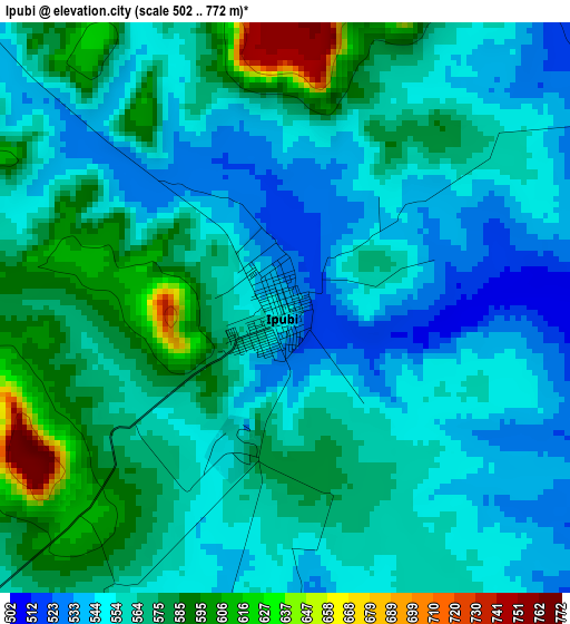
Below is the Elevation map of Ipubi, which displays elevation range with different colors. Scale of the first map is from 502 to 772 m (1647 to 2533 ft) with average elevation of 563 meters (=1847 ft) [note 1]
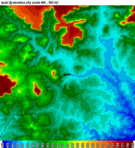
These maps also provides idea of topography and contour of this city, they are displayed at different zoom levels. More info about maps, scale and edge coordinates you can find below images.
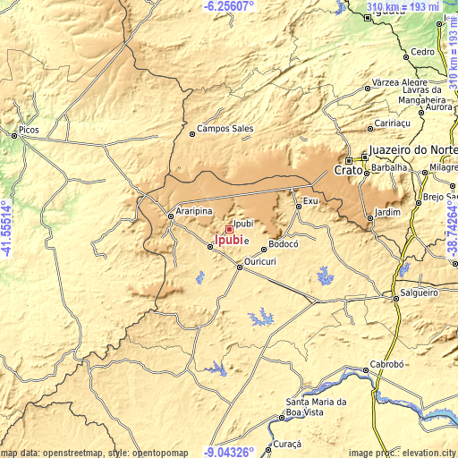
| \ | Map #1 | Map #2 | Topo.Map |
| Scale [m] | 502..772 m | 465..803 m | × |
| Scale [ft] | 1647..2533 ft | 1526..2635 ft | × |
| Average | 563 m = 1847 ft | 574.5 m = 1885 ft | × |
| Width | 9.69 km = 6 mi | 19.37 km = 12 mi | 309.9 km = 192.6 mi |
| Height | 9.69 km = 6 mi | 19.37 km = 12 mi | 309.9 km = 192.6 mi |
| ↑Max Latitude | -7.608384° | -7.564823° | -6.25607° |
| Latitude at center | -7.65194° | -7.65194° | -7.65194° |
| ↓Min Latitude | -7.695492° | -7.739039° | -9.04326° |
| ← Min Longitude | -40.192835° | -40.236781° | -41.55514° |
| Longitude center | -40.14889° | -40.14889° | -40.14889° |
| →Max Longitude | -40.104945° | -40.060999° | -38.74264° |
Nearby cities:
Cities around Ipubi sort by population:
• Crato elevation 430 m
93.8 km,  60°
60°
• Araripina 624 m
39.4 km,  282°
282°
• Barbalha 422 m
100.5 km,  67°
67°
• Ouricuri 451 m
26.7 km,  163°
163°
• Trindade 523 m
17.9 km,  226°
226°
• Campos Sales 567 m
68.9 km,  338°
338°
• Ipueiras 558 m
76.4 km,  334°
334°
• Araripe 677 m
50.2 km,  13°
13°
• Assaré 446 m
91.6 km,  19°
19°
• Exu 525 m
49.3 km, 71°
• Parnamirim 396 m
79.5 km,  127°
127°
• Simões 442 m
74 km,  274°
274°
Multilingual:
 En español:
Ipubi elevación 543 m.
 En France:
Ipubi élévation 543 m.


Sources and notes:
- [note 1] Map square and city borders are not equal. Map elevation data is calculated only from area inside that square.
- [src 1] Elevation data from geonames database provided with same terms of usage.
- [src 2] The elevation map of Ipubi is generated using elevation data from NASA's 3 arcsec (90m) resolution SRTM data.
- [src 3] Base (background) map © OpenStreetMap contributors tiles are generated by Geofabrik and OpenTopoMap.
Copyright & License:
This Ipubi Elevation Map is licensed under CC BY-SA. You may reuse any part from this page, if you give a proper credit by linking to this URL:
 More info on terms of use page.