Barbalha elevation
Barbalha (Ceará), Brazil elevation is 422 meters and Barbalha elevation in feet is 1385 ft above sea level [src 1]. Barbalha is a populated place (feature code) with elevation that is 40 meters (131 ft) bigger than average city elevation in Brazil.
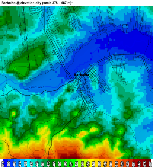
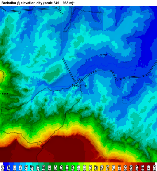
Below is the Elevation map of Barbalha, which displays elevation range with different colors. Scale of the first map is from 378 to 687 m (1240 to 2254 ft) with average elevation of 453.7 meters (=1489 ft) [note 1]
These maps also provides idea of topography and contour of this city, they are displayed at different zoom levels. More info about maps, scale and edge coordinates you can find below images.
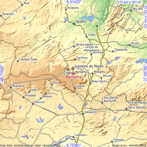
| \ | Map #1 | Map #2 | Topo.Map |
| Scale [m] | 378..687 m | 349..963 m | × |
| Scale [ft] | 1240..2254 ft | 1145..3159 ft | × |
| Average | 453.7 m = 1489 ft | 518.6 m = 1701 ft | × |
| Width | 9.69 km = 6 mi | 19.39 km = 12 mi | 310.1 km = 192.7 mi |
| Height | 9.69 km = 6 mi | 19.39 km = 12 mi | 310.2 km = 192.7 mi |
| ↑Max Latitude | -7.26752° | -7.223925° | -5.91425° |
| Latitude at center | -7.31111° | -7.31111° | -7.31111° |
| ↓Min Latitude | -7.354696° | -7.398278° | -8.70361° |
| ← Min Longitude | -39.348115° | -39.392061° | -40.71042° |
| Longitude center | -39.30417° | -39.30417° | -39.30417° |
| →Max Longitude | -39.260225° | -39.216279° | -37.89792° |
Nearby cities:
Cities around Barbalha sort by population:
• Juazeiro do Norte elevation 413 m
11 km,  353°
353°
• Crato 430 m
14.4 km,  306°
306°
• Brejo Santo 386 m
40.4 km,  120°
120°
• Lavras da Mangabeira 241 m
72.5 km,  31°
31°
• Missão Velha 364 m
19 km,  68°
68°
• Caririaçu 712 m
30 km,  4°
4°
• Milagres 341 m
39.6 km,  90°
90°
• Barro 290 m
81.9 km,  36°
36°
• Assaré 446 m
79.5 km, 307°
• Farias Brito 344 m
51.2 km,  325°
325°
• Exu 525 m
51.4 km,  244°
244°
• Aurora 273 m
55.3 km, 42°
Multilingual:
 En español:
Barbalha elevación 422 m.
 En France:
Barbalha élévation 422 m.
 Auf Deutsch:
Barbalha höhe über dem Meeresspiegel ist 422 m.

Sources and notes:
- [note 1] Map square and city borders are not equal. Map elevation data is calculated only from area inside that square.
- [src 1] Elevation data from geonames database provided with same terms of usage.
- [src 2] The elevation map of Barbalha is generated using elevation data from NASA's 3 arcsec (90m) resolution SRTM data.
- [src 3] Base (background) map © OpenStreetMap contributors tiles are generated by Geofabrik and OpenTopoMap.
Copyright & License:
This Barbalha Elevation Map is licensed under CC BY-SA. You may reuse any part from this page, if you give a proper credit by linking to this URL:
 More info on terms of use page.