Grajaú elevation
Grajaú (Maranhão), Brazil elevation is 163 meters and Grajaú elevation in feet is 535 ft above sea level [src 1]. Grajaú is a populated place (feature code) with elevation that is 219 meters (719 ft) smaller than average city elevation in Brazil.
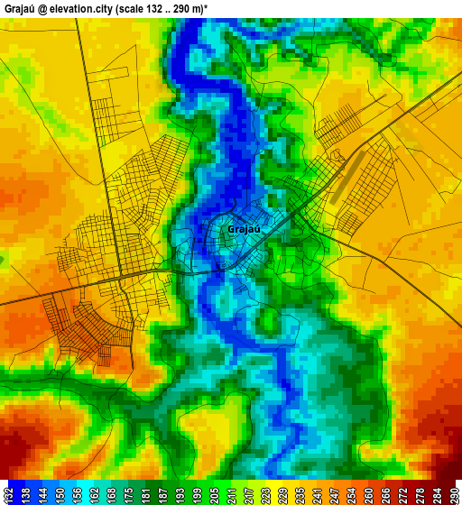
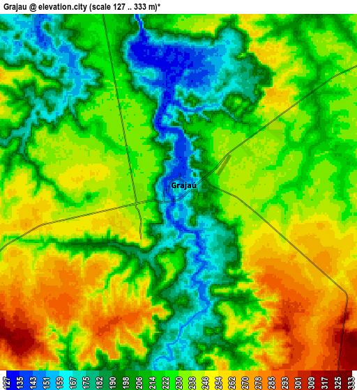
Below is the Elevation map of Grajaú, which displays elevation range with different colors. Scale of the first map is from 132 to 290 m (433 to 951 ft) with average elevation of 211.6 meters (=694 ft) [note 1]
These maps also provides idea of topography and contour of this city, they are displayed at different zoom levels. More info about maps, scale and edge coordinates you can find below images.
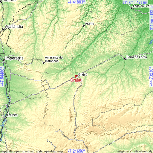
| \ | Map #1 | Map #2 | Topo.Map |
| Scale [m] | 132..290 m | 127..333 m | × |
| Scale [ft] | 433..951 ft | 417..1093 ft | × |
| Average | 211.6 m = 694 ft | 224 m = 735 ft | × |
| Width | 9.72 km = 6 mi | 19.44 km = 12.1 mi | 311.1 km = 193.3 mi |
| Height | 9.72 km = 6 mi | 19.44 km = 12.1 mi | 311.1 km = 193.3 mi |
| ↑Max Latitude | -5.775719° | -5.731996° | -4.41883° |
| Latitude at center | -5.81944° | -5.81944° | -5.81944° |
| ↓Min Latitude | -5.863157° | -5.906871° | -7.21656° |
| ← Min Longitude | -46.182555° | -46.226501° | -47.54486° |
| Longitude center | -46.13861° | -46.13861° | -46.13861° |
| →Max Longitude | -46.094665° | -46.050719° | -44.73236° |
Nearby cities:
Cities around Grajaú sort by population:
• Imperatriz elevation 127 m
153.2 km,  282°
282°
• Barra do Corda 100 m
105 km,  70°
70°
• Tuntum 109 m
176.3 km, 69°
• Porto Franco 165 m
150.8 km,  247°
247°
• Esperantinópolis 51 m
190.5 km,  56°
56°
• Riachão 385 m
179.5 km,  197°
197°
• Bom Jardim 426 m
138.5 km, 195°
• Amarante do Maranhão 247 m
72.5 km,  292°
292°
• São Raimundo das Mangabeiras 241 m
152.2 km,  151°
151°
• Montes Altos 242 m
102.7 km,  269°
269°
• Lago dos Rodrigues 68 m
185.6 km,  43°
43°
• Paulo Ramos 64 m
182.4 km,  33°
33°
Multilingual:
 En español:
Grajaú elevación 163 m.
 En France:
Grajaú élévation 163 m.


Sources and notes:
- [note 1] Map square and city borders are not equal. Map elevation data is calculated only from area inside that square.
- [src 1] Elevation data from geonames database provided with same terms of usage.
- [src 2] The elevation map of Grajaú is generated using elevation data from NASA's 3 arcsec (90m) resolution SRTM data.
- [src 3] Base (background) map © OpenStreetMap contributors tiles are generated by Geofabrik and OpenTopoMap.
Copyright & License:
This Grajaú Elevation Map is licensed under CC BY-SA. You may reuse any part from this page, if you give a proper credit by linking to this URL:
 More info on terms of use page.