Amarante do Maranhão elevation
Amarante do Maranhão (Maranhão), Brazil elevation is 247 meters and Amarante do Maranhão elevation in feet is 810 ft above sea level [src 1]. Amarante do Maranhão is a populated place (feature code) with elevation that is 135 meters (443 ft) smaller than average city elevation in Brazil.
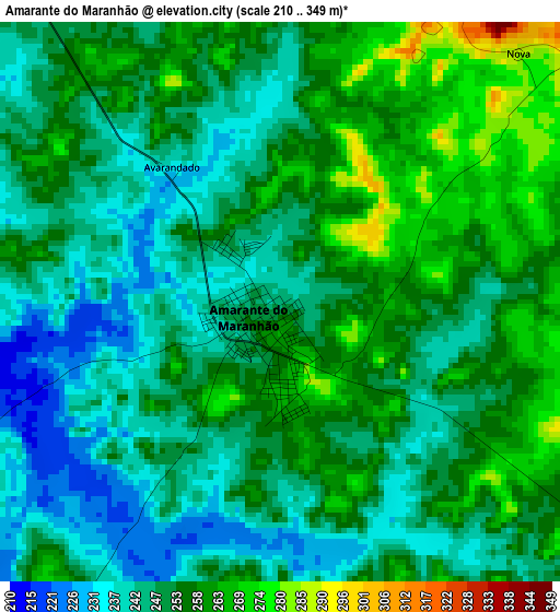
Below is the Elevation map of Amarante do Maranhão, which displays elevation range with different colors. Scale of the first map is from 210 to 349 m (689 to 1145 ft) with average elevation of 251.3 meters (=824 ft) [note 1]
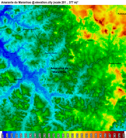
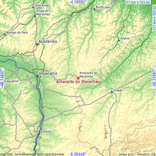
These maps also provides idea of topography and contour of this city, they are displayed at different zoom levels. More info about maps, scale and edge coordinates you can find below images.
| \ | Map #1 | Map #2 | Topo.Map |
| Scale [m] | 210..349 m | 201..377 m | × |
| Scale [ft] | 689..1145 ft | 659..1237 ft | × |
| Average | 251.3 m = 824 ft | 261.2 m = 857 ft | × |
| Width | 9.73 km = 6 mi | 19.45 km = 12.1 mi | 311.2 km = 193.4 mi |
| Height | 9.73 km = 6 mi | 19.45 km = 12.1 mi | 311.2 km = 193.4 mi |
| ↑Max Latitude | -5.52293° | -5.479187° | -4.16552° |
| Latitude at center | -5.56667° | -5.56667° | -5.56667° |
| ↓Min Latitude | -5.610406° | -5.65414° | -6.96448° |
| ← Min Longitude | -46.786165° | -46.830111° | -48.14847° |
| Longitude center | -46.74222° | -46.74222° | -46.74222° |
| →Max Longitude | -46.698275° | -46.654329° | -45.33597° |
Nearby cities:
Cities around Amarante do Maranhão sort by population:
• Imperatriz elevation 127 m
83.1 km,  273°
273°
• Barra do Corda 100 m
166 km,  87°
87°
• Grajaú 163 m
72.5 km,  112°
112°
• Lago da Pedra 67 m
219.1 km,  49°
49°
• Carolina 175 m
212.2 km,  202°
202°
• Porto Franco 165 m
112.4 km,  220°
220°
• São Geraldo do Araguaia 131 m
220.9 km,  245°
245°
• Riachão 385 m
200.1 km,  176°
176°
• Bom Jardim 426 m
163.7 km,  169°
169°
• São Raimundo das Mangabeiras 241 m
213.6 km,  139°
139°
• Montes Altos 242 m
46.6 km,  230°
230°
• Paulo Ramos 64 m
208 km, 53°
Multilingual:
 En español:
Amarante do Maranhão elevación 247 m.
 En France:
Amarante do Maranhão élévation 247 m.
 Auf Deutsch:
Amarante do Maranhão höhe über dem Meeresspiegel ist 247 m.
 На русском:
Amarante do Maranhão высота над уровнем моря 247 м
Sources and notes:
- [note 1] Map square and city borders are not equal. Map elevation data is calculated only from area inside that square.
- [src 1] Elevation data from geonames database provided with same terms of usage.
- [src 2] The elevation map of Amarante do Maranhão is generated using elevation data from NASA's 3 arcsec (90m) resolution SRTM data.
- [src 3] Base (background) map © OpenStreetMap contributors tiles are generated by Geofabrik and OpenTopoMap.
Copyright & License:
This Amarante do Maranhão Elevation Map is licensed under CC BY-SA. You may reuse any part from this page, if you give a proper credit by linking to this URL:
 More info on terms of use page.