Tuntum elevation
Tuntum (Maranhão), Brazil elevation is 109 meters and Tuntum elevation in feet is 358 ft above sea level [src 1]. Tuntum is a populated place (feature code) with elevation that is 273 meters (896 ft) smaller than average city elevation in Brazil.
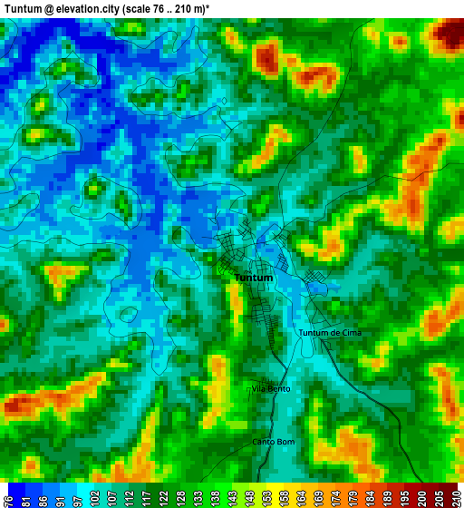
Below is the Elevation map of Tuntum, which displays elevation range with different colors. Scale of the first map is from 76 to 210 m (249 to 689 ft) with average elevation of 119.1 meters (=391 ft) [note 1]
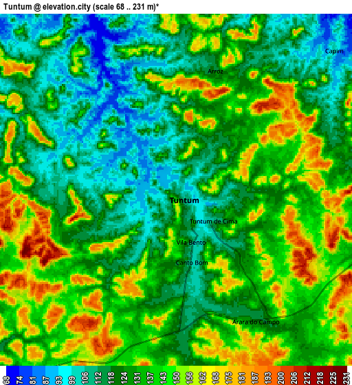
These maps also provides idea of topography and contour of this city, they are displayed at different zoom levels. More info about maps, scale and edge coordinates you can find below images.
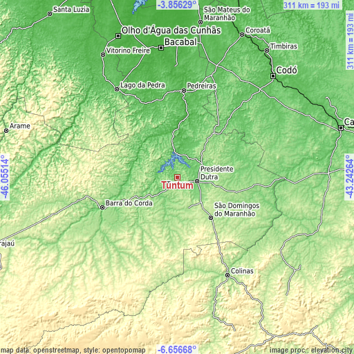
| \ | Map #1 | Map #2 | Topo.Map |
| Scale [m] | 76..210 m | 68..231 m | × |
| Scale [ft] | 249..689 ft | 223..758 ft | × |
| Average | 119.1 m = 391 ft | 132.9 m = 436 ft | × |
| Width | 9.73 km = 6 mi | 19.46 km = 12.1 mi | 311.4 km = 193.5 mi |
| Height | 9.73 km = 6 mi | 19.46 km = 12.1 mi | 311.4 km = 193.5 mi |
| ↑Max Latitude | -5.214298° | -5.170533° | -3.85629° |
| Latitude at center | -5.25806° | -5.25806° | -5.25806° |
| ↓Min Latitude | -5.301819° | -5.345575° | -6.65668° |
| ← Min Longitude | -44.692835° | -44.736781° | -46.05514° |
| Longitude center | -44.64889° | -44.64889° | -44.64889° |
| →Max Longitude | -44.604945° | -44.560999° | -43.24264° |
Nearby cities:
Cities around Tuntum sort by population:
• Barra do Corda elevation 100 m
71.3 km,  247°
247°
• Bacabal 28 m
108.6 km,  351°
351°
• Presidente Dutra 108 m
17.9 km,  101°
101°
• Colinas 142 m
96.1 km,  152°
152°
• São Domingos do Maranhão 179 m
45.8 km,  140°
140°
• Buriti Bravo 227 m
110.8 km,  125°
125°
• Dom Pedro 136 m
33.8 km,  43°
43°
• Esperantinópolis 51 m
44 km, 351°
• Poção de Pedras 41 m
69.4 km,  341°
341°
• Fortuna 210 m
75.8 km, 134°
• Paulo Ramos 64 m
111.8 km,  324°
324°
• Lago dos Rodrigues 68 m
80.6 km,  332°
332°
Multilingual:
 En español:
Tuntum elevación 109 m.
 En France:
Tuntum élévation 109 m.


Sources and notes:
- [note 1] Map square and city borders are not equal. Map elevation data is calculated only from area inside that square.
- [src 1] Elevation data from geonames database provided with same terms of usage.
- [src 2] The elevation map of Tuntum is generated using elevation data from NASA's 3 arcsec (90m) resolution SRTM data.
- [src 3] Base (background) map © OpenStreetMap contributors tiles are generated by Geofabrik and OpenTopoMap.
Copyright & License:
This Tuntum Elevation Map is licensed under CC BY-SA. You may reuse any part from this page, if you give a proper credit by linking to this URL:
 More info on terms of use page.