Poção de Pedras elevation
Poção de Pedras (Maranhão, Igarapé Grande), Brazil elevation is 41 meters and Poção de Pedras elevation in feet is 135 ft above sea level [src 1]. Poção de Pedras is a populated place (feature code) with elevation that is 341 meters (1119 ft) smaller than average city elevation in Brazil.
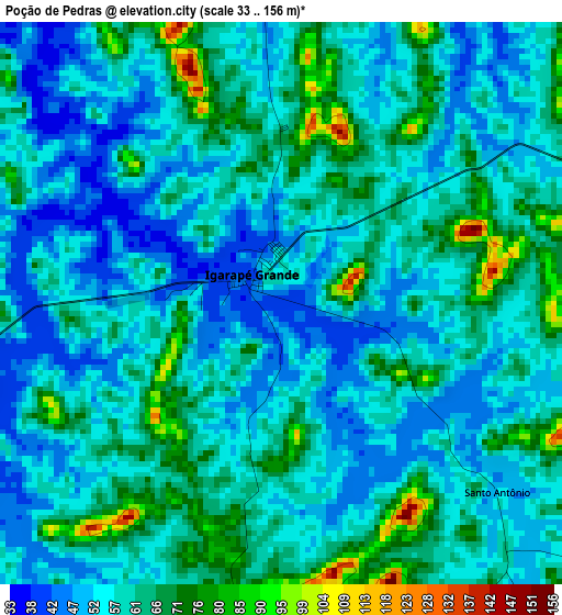
Below is the Elevation map of Poção de Pedras, which displays elevation range with different colors. Scale of the first map is from 33 to 156 m (108 to 512 ft) with average elevation of 58.5 meters (=192 ft) [note 1]
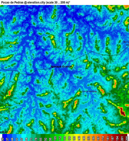
These maps also provides idea of topography and contour of this city, they are displayed at different zoom levels. More info about maps, scale and edge coordinates you can find below images.
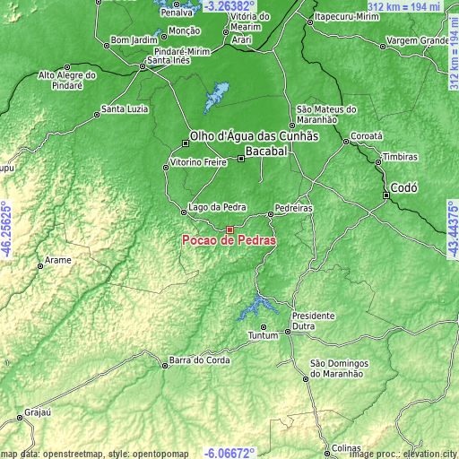
| \ | Map #1 | Map #2 | Topo.Map |
| Scale [m] | 33..156 m | 30..208 m | × |
| Scale [ft] | 108..512 ft | 98..682 ft | × |
| Average | 58.5 m = 192 ft | 64.1 m = 210 ft | × |
| Width | 9.74 km = 6.1 mi | 19.48 km = 12.1 mi | 311.7 km = 193.7 mi |
| Height | 9.74 km = 6.1 mi | 19.48 km = 12.1 mi | 311.7 km = 193.7 mi |
| ↑Max Latitude | -4.622869° | -4.579065° | -3.26382° |
| Latitude at center | -4.66667° | -4.66667° | -4.66667° |
| ↓Min Latitude | -4.710468° | -4.754264° | -6.06672° |
| ← Min Longitude | -44.893945° | -44.937891° | -46.25625° |
| Longitude center | -44.85° | -44.85° | -44.85° |
| →Max Longitude | -44.806055° | -44.762109° | -43.44375° |
Nearby cities:
Cities around Poção de Pedras sort by population:
• Bacabal elevation 28 m
42.2 km,  8°
8°
• Presidente Dutra 108 m
80 km,  150°
150°
• São Mateus do Maranhão 47 m
81 km,  30°
30°
• Lago da Pedra 67 m
60.3 km,  314°
314°
• Tuntum 109 m
69.4 km,  161°
161°
• Dom Pedro 136 m
61.5 km,  132°
132°
• Pio XII 13 m
98.6 km,  340°
340°
• Vitorino Freire 44 m
81.6 km,  328°
328°
• Esperantinópolis 51 m
27.2 km,  144°
144°
• Paulo Ramos 55 m
62.2 km,  323°
323°
• Paulo Ramos 64 m
49.9 km,  299°
299°
• Lago dos Rodrigues 68 m
15.6 km,  292°
292°
Multilingual:
 En español:
Poção de Pedras elevación 41 m.
 En France:
Poção de Pedras élévation 41 m.
 Auf Deutsch:
Poção de Pedras höhe über dem Meeresspiegel ist 41 m.

Sources and notes:
- [note 1] Map square and city borders are not equal. Map elevation data is calculated only from area inside that square.
- [src 1] Elevation data from geonames database provided with same terms of usage.
- [src 2] The elevation map of Poção de Pedras is generated using elevation data from NASA's 3 arcsec (90m) resolution SRTM data.
- [src 3] Base (background) map © OpenStreetMap contributors tiles are generated by Geofabrik and OpenTopoMap.
Copyright & License:
This Poção de Pedras Elevation Map is licensed under CC BY-SA. You may reuse any part from this page, if you give a proper credit by linking to this URL:
 More info on terms of use page.