Pio XII elevation
Pio XII (Maranhão), Brazil elevation is 13 meters and Pio XII elevation in feet is 43 ft above sea level [src 1]. Pio XII is a populated place (feature code) with elevation that is 369 meters (1211 ft) smaller than average city elevation in Brazil.
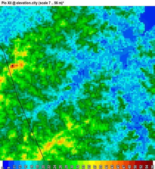
Below is the Elevation map of Pio XII, which displays elevation range with different colors. Scale of the first map is from 7 to 56 m (23 to 184 ft) with average elevation of 20.6 meters (=68 ft) [note 1]
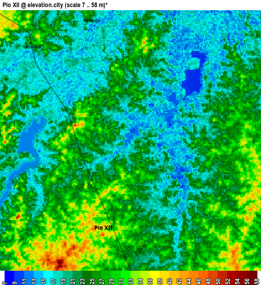
These maps also provides idea of topography and contour of this city, they are displayed at different zoom levels. More info about maps, scale and edge coordinates you can find below images.
| \ | Map #1 | Map #2 | Topo.Map |
| Scale [m] | 7..56 m | 7..58 m | × |
| Scale [ft] | 23..184 ft | 23..190 ft | × |
| Average | 20.6 m = 68 ft | 23 m = 75 ft | × |
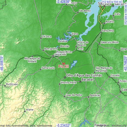
| Width | 9.75 km = 6.1 mi | 19.5 km = 12.1 mi | 312 km = 193.9 mi |
| Height | 9.75 km = 6.1 mi | 19.5 km = 12.1 mi | 312 km = 193.9 mi |
| ↑Max Latitude | -3.788652° | -3.744801° | -2.42838° |
| Latitude at center | -3.8325° | -3.8325° | -3.8325° |
| ↓Min Latitude | -3.876346° | -3.92019° | -5.23432° |
| ← Min Longitude | -45.196445° | -45.240391° | -46.55875° |
| Longitude center | -45.1525° | -45.1525° | -45.1525° |
| →Max Longitude | -45.108555° | -45.064609° | -43.74625° |
Nearby cities:
Cities around Pio XII sort by population:
• Bacabal elevation 28 m
64.9 km,  141°
141°
• Santa Inês 31 m
31.3 km,  306°
306°
• Viana 13 m
70 km,  13°
13°
• Lago da Pedra 67 m
51.4 km,  190°
190°
• Pindaré Mirim 24 m
32.7 km,  319°
319°
• Penalva 17 m
59.9 km,  357°
357°
• Arari 9 m
59 km,  44°
44°
• Vitória do Mearim 15 m
51.7 km, 37°
• Vitorino Freire 44 m
25.2 km,  202°
202°
• Monção 26 m
39.4 km,  343°
343°
• Paulo Ramos 55 m
42.9 km,  184°
184°
• Paulo Ramos 64 m
68.7 km, 188°
Multilingual:
 En español:
Pio XII elevación 13 m.
 En France:
Pio XII élévation 13 m.


Sources and notes:
- [note 1] Map square and city borders are not equal. Map elevation data is calculated only from area inside that square.
- [src 1] Elevation data from geonames database provided with same terms of usage.
- [src 2] The elevation map of Pio XII is generated using elevation data from NASA's 3 arcsec (90m) resolution SRTM data.
- [src 3] Base (background) map © OpenStreetMap contributors tiles are generated by Geofabrik and OpenTopoMap.
Copyright & License:
This Pio XII Elevation Map is licensed under CC BY-SA. You may reuse any part from this page, if you give a proper credit by linking to this URL:
 More info on terms of use page.