Igaci elevation
Igaci (Alagoas), Brazil elevation is 250 meters and Igaci elevation in feet is 820 ft above sea level [src 1]. Igaci is a populated place (feature code) with elevation that is 132 meters (433 ft) smaller than average city elevation in Brazil.
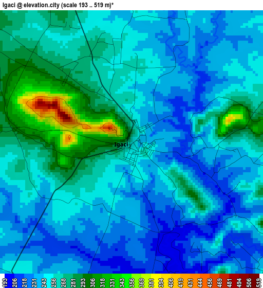
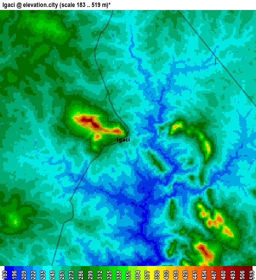
Below is the Elevation map of Igaci, which displays elevation range with different colors. Scale of the first map is from 193 to 519 m (633 to 1703 ft) with average elevation of 254.1 meters (=834 ft) [note 1]
These maps also provides idea of topography and contour of this city, they are displayed at different zoom levels. More info about maps, scale and edge coordinates you can find below images.
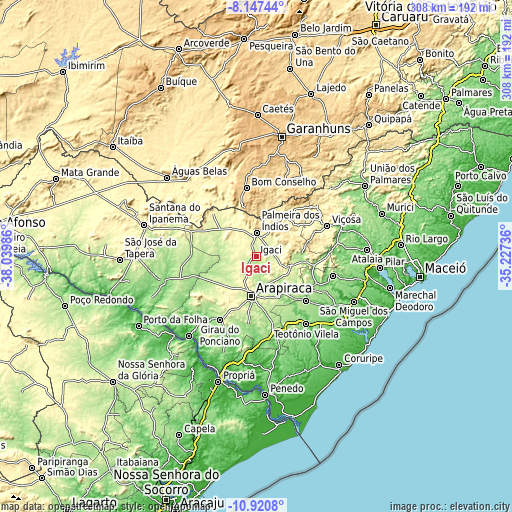
| \ | Map #1 | Map #2 | Topo.Map |
| Scale [m] | 193..519 m | 183..519 m | × |
| Scale [ft] | 633..1703 ft | 600..1703 ft | × |
| Average | 254.1 m = 834 ft | 260.3 m = 854 ft | × |
| Width | 9.64 km = 6 mi | 19.27 km = 12 mi | 308.4 km = 191.6 mi |
| Height | 9.64 km = 6 mi | 19.27 km = 12 mi | 308.4 km = 191.6 mi |
| ↑Max Latitude | -9.493599° | -9.450253° | -8.14744° |
| Latitude at center | -9.53694° | -9.53694° | -9.53694° |
| ↓Min Latitude | -9.580275° | -9.623605° | -10.9208° |
| ← Min Longitude | -36.677555° | -36.721501° | -38.03986° |
| Longitude center | -36.63361° | -36.63361° | -36.63361° |
| →Max Longitude | -36.589665° | -36.545719° | -35.22736° |
Nearby cities:
Cities around Igaci sort by population:
• Arapiraca elevation 275 m
24.2 km,  187°
187°
• Bom Conselho 655 m
41.1 km,  352°
352°
• Cajueiro 215 m
28.4 km,  134°
134°
• Lagoa da Canoa 289 m
34.5 km,  199°
199°
• Maribondo 160 m
36.3 km,  97°
97°
• Anadia 147 m
39.7 km,  114°
114°
• Major Isidoro 191 m
38.5 km,  270°
270°
• Quebrangulo 370 m
30.1 km,  36°
36°
• Taquarana 242 m
19.2 km, 128°
• Limoeiro de Anadia 125 m
26.8 km,  147°
147°
• Coité do Nóia 288 m
12.2 km, 150°
• Minador do Negrão 283 m
36.1 km,  315°
315°
Multilingual:
 En español:
Igaci elevación 250 m.
 En France:
Igaci élévation 250 m.


Sources and notes:
- [note 1] Map square and city borders are not equal. Map elevation data is calculated only from area inside that square.
- [src 1] Elevation data from geonames database provided with same terms of usage.
- [src 2] The elevation map of Igaci is generated using elevation data from NASA's 3 arcsec (90m) resolution SRTM data.
- [src 3] Base (background) map © OpenStreetMap contributors tiles are generated by Geofabrik and OpenTopoMap.
Copyright & License:
This Igaci Elevation Map is licensed under CC BY-SA. You may reuse any part from this page, if you give a proper credit by linking to this URL:
 More info on terms of use page.