Lagoa da Canoa elevation
Lagoa da Canoa (Alagoas), Brazil elevation is 289 meters and Lagoa da Canoa elevation in feet is 948 ft above sea level [src 1]. Lagoa da Canoa is a populated place (feature code) with elevation that is 93 meters (305 ft) smaller than average city elevation in Brazil.
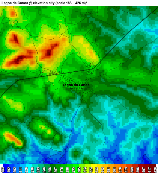
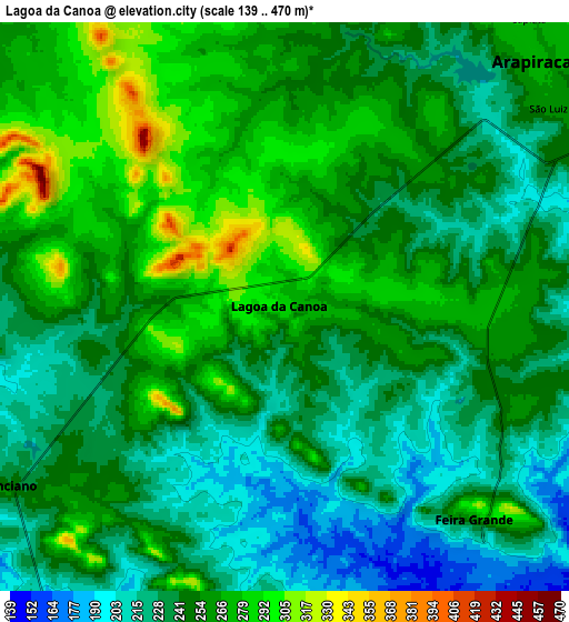
Below is the Elevation map of Lagoa da Canoa, which displays elevation range with different colors. Scale of the first map is from 183 to 426 m (600 to 1398 ft) with average elevation of 266.5 meters (=874 ft) [note 1]
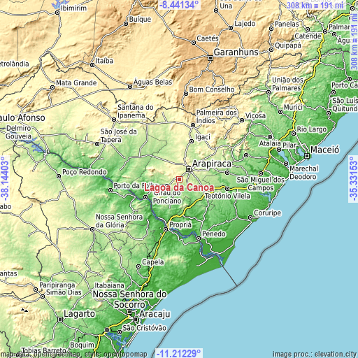
These maps also provides idea of topography and contour of this city, they are displayed at different zoom levels. More info about maps, scale and edge coordinates you can find below images.
| \ | Map #1 | Map #2 | Topo.Map |
| Scale [m] | 183..426 m | 139..470 m | × |
| Scale [ft] | 600..1398 ft | 456..1542 ft | × |
| Average | 266.5 m = 874 ft | 249.1 m = 817 ft | × |
| Width | 9.63 km = 6 mi | 19.26 km = 12 mi | 308.1 km = 191.4 mi |
| Height | 9.63 km = 6 mi | 19.26 km = 12 mi | 308.1 km = 191.4 mi |
| ↑Max Latitude | -9.786417° | -9.743108° | -8.44134° |
| Latitude at center | -9.82972° | -9.82972° | -9.82972° |
| ↓Min Latitude | -9.873017° | -9.916309° | -11.21229° |
| ← Min Longitude | -36.781725° | -36.825671° | -38.14403° |
| Longitude center | -36.73778° | -36.73778° | -36.73778° |
| →Max Longitude | -36.693835° | -36.649889° | -35.33153° |
Nearby cities:
Cities around Lagoa da Canoa sort by population:
• Arapiraca elevation 275 m
12 km,  44°
44°
• Cajueiro 215 m
33.9 km,  68°
68°
• Girau do Ponciano 248 m
11.7 km,  238°
238°
• São Sebastião 204 m
23.2 km,  119°
119°
• Traipu 30 m
33 km, 241°
• Junqueiro 186 m
30.6 km,  110°
110°
• Igaci 250 m
34.5 km,  19°
19°
• Taquarana 242 m
33.4 km,  52°
52°
• Igreja Nova 34 m
33.9 km,  165°
165°
• Gararu 17 m
40.8 km,  247°
247°
• Limoeiro de Anadia 125 m
27.6 km, 68°
• Coité do Nóia 288 m
28 km, 38°
Multilingual:
 En español:
Lagoa da Canoa elevación 289 m.
 En France:
Lagoa da Canoa élévation 289 m.
 Auf Deutsch:
Lagoa da Canoa höhe über dem Meeresspiegel ist 289 m.

Sources and notes:
- [note 1] Map square and city borders are not equal. Map elevation data is calculated only from area inside that square.
- [src 1] Elevation data from geonames database provided with same terms of usage.
- [src 2] The elevation map of Lagoa da Canoa is generated using elevation data from NASA's 3 arcsec (90m) resolution SRTM data.
- [src 3] Base (background) map © OpenStreetMap contributors tiles are generated by Geofabrik and OpenTopoMap.
Copyright & License:
This Lagoa da Canoa Elevation Map is licensed under CC BY-SA. You may reuse any part from this page, if you give a proper credit by linking to this URL:
 More info on terms of use page.