Mari elevation
Mari (Paraíba), Brazil elevation is 149 meters and Mari elevation in feet is 489 ft above sea level [src 1]. Mari is a populated place (feature code) with elevation that is 233 meters (764 ft) smaller than average city elevation in Brazil.
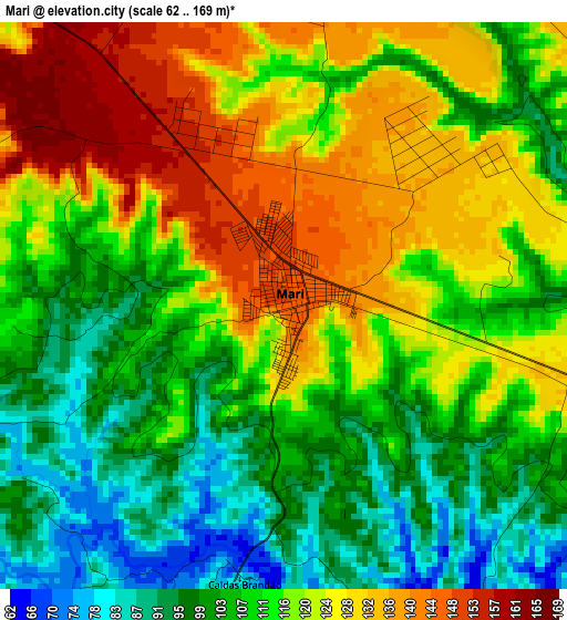
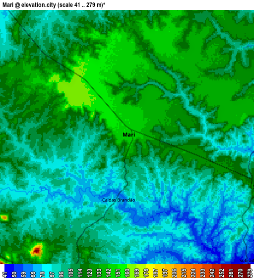
Below is the Elevation map of Mari, which displays elevation range with different colors. Scale of the first map is from 62 to 169 m (203 to 554 ft) with average elevation of 114.7 meters (=376 ft) [note 1]
These maps also provides idea of topography and contour of this city, they are displayed at different zoom levels. More info about maps, scale and edge coordinates you can find below images.
| \ | Map #1 | Map #2 | Topo.Map |
| Scale [m] | 62..169 m | 41..279 m | × |
| Scale [ft] | 203..554 ft | 135..915 ft | × |
| Average | 114.7 m = 376 ft | 109.3 m = 359 ft | × |
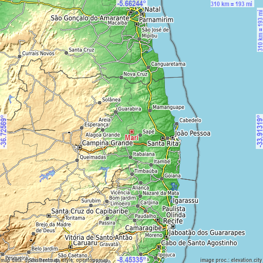
| Width | 9.7 km = 6 mi | 19.4 km = 12.1 mi | 310.3 km = 192.8 mi |
| Height | 9.7 km = 6 mi | 19.4 km = 12.1 mi | 310.3 km = 192.8 mi |
| ↑Max Latitude | -7.016386° | -6.972768° | -5.66244° |
| Latitude at center | -7.06° | -7.06° | -7.06° |
| ↓Min Latitude | -7.10361° | -7.147216° | -8.45335° |
| ← Min Longitude | -35.363385° | -35.407331° | -36.72569° |
| Longitude center | -35.31944° | -35.31944° | -35.31944° |
| →Max Longitude | -35.275495° | -35.231549° | -33.91319° |
Nearby cities:
Cities around Mari sort by population:
• Guarabira elevation 94 m
29.6 km,  320°
320°
• Mamanguape 39 m
32.6 km,  40°
40°
• Itabaiana 47 m
29.9 km,  182°
182°
• Alagoa Grande 334 m
36 km,  252°
252°
• Juripiranga 117 m
36 km,  165°
165°
• Pilar 38 m
24 km,  164°
164°
• Alagoinha 136 m
27.7 km,  296°
296°
• Cruz do Espírito Santo 19 m
27.2 km,  109°
109°
• Gurinhém 98 m
13.6 km,  238°
238°
• Mogeiro 119 m
31.9 km,  213°
213°
• Salgado de São Félix 64 m
35.6 km,  202°
202°
• Mulungu 89 m
16.2 km,  284°
284°
Multilingual:
 En español:
Mari elevación 149 m.
 En France:
Mari élévation 149 m.


Sources and notes:
- [note 1] Map square and city borders are not equal. Map elevation data is calculated only from area inside that square.
- [src 1] Elevation data from geonames database provided with same terms of usage.
- [src 2] The elevation map of Mari is generated using elevation data from NASA's 3 arcsec (90m) resolution SRTM data.
- [src 3] Base (background) map © OpenStreetMap contributors tiles are generated by Geofabrik and OpenTopoMap.
Copyright & License:
This Mari Elevation Map is licensed under CC BY-SA. You may reuse any part from this page, if you give a proper credit by linking to this URL:
 More info on terms of use page.