Parelhas elevation
Parelhas (Rio Grande do Norte), Brazil elevation is 274 meters and Parelhas elevation in feet is 899 ft above sea level [src 1]. Parelhas is a populated place (feature code) with elevation that is 108 meters (354 ft) smaller than average city elevation in Brazil.
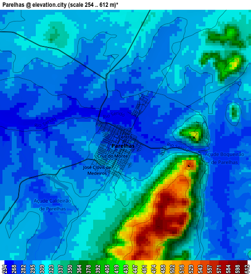
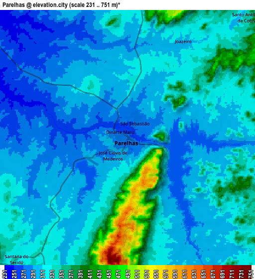
Below is the Elevation map of Parelhas, which displays elevation range with different colors. Scale of the first map is from 254 to 612 m (833 to 2008 ft) with average elevation of 315.9 meters (=1036 ft) [note 1]
These maps also provides idea of topography and contour of this city, they are displayed at different zoom levels. More info about maps, scale and edge coordinates you can find below images.
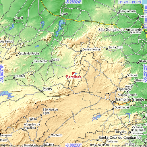
| \ | Map #1 | Map #2 | Topo.Map |
| Scale [m] | 254..612 m | 231..751 m | × |
| Scale [ft] | 833..2008 ft | 758..2464 ft | × |
| Average | 315.9 m = 1036 ft | 321.6 m = 1055 ft | × |
| Width | 9.71 km = 6 mi | 19.41 km = 12.1 mi | 310.6 km = 193 mi |
| Height | 9.71 km = 6 mi | 19.41 km = 12.1 mi | 310.6 km = 193 mi |
| ↑Max Latitude | -6.644132° | -6.60048° | -5.28924° |
| Latitude at center | -6.68778° | -6.68778° | -6.68778° |
| ↓Min Latitude | -6.731424° | -6.775065° | -8.08233° |
| ← Min Longitude | -36.701445° | -36.745391° | -38.06375° |
| Longitude center | -36.6575° | -36.6575° | -36.6575° |
| →Max Longitude | -36.613555° | -36.569609° | -35.25125° |
Nearby cities:
Cities around Parelhas sort by population:
• Patos elevation 243 m
78.3 km,  241°
241°
• Caicó 161 m
54.9 km,  297°
297°
• Currais Novos 361 m
49.9 km,  18°
18°
• Santa Luzia 304 m
35.4 km,  234°
234°
• Cuité 670 m
60.1 km,  67°
67°
• Picuí 445 m
39.6 km,  60°
60°
• Jardim do Seridó 223 m
17.3 km,  311°
311°
• Taperoá 533 m
60.7 km,  197°
197°
• Nova Floresta 670 m
56.4 km, 62°
• Soledade 526 m
52.4 km,  141°
141°
• Pocinhos 633 m
78.8 km,  123°
123°
• Lagoa Nova 697 m
68.1 km, 16°
Multilingual:
 En español:
Parelhas elevación 274 m.
 En France:
Parelhas élévation 274 m.
 Auf Deutsch:
Parelhas höhe über dem Meeresspiegel ist 274 m.

Sources and notes:
- [note 1] Map square and city borders are not equal. Map elevation data is calculated only from area inside that square.
- [src 1] Elevation data from geonames database provided with same terms of usage.
- [src 2] The elevation map of Parelhas is generated using elevation data from NASA's 3 arcsec (90m) resolution SRTM data.
- [src 3] Base (background) map © OpenStreetMap contributors tiles are generated by Geofabrik and OpenTopoMap.
Copyright & License:
This Parelhas Elevation Map is licensed under CC BY-SA. You may reuse any part from this page, if you give a proper credit by linking to this URL:
 More info on terms of use page.