Cuité elevation
Cuité (Paraíba), Brazil elevation is 670 meters and Cuité elevation in feet is 2198 ft above sea level [src 1]. Cuité is a populated place (feature code) with elevation that is 288 meters (945 ft) bigger than average city elevation in Brazil.
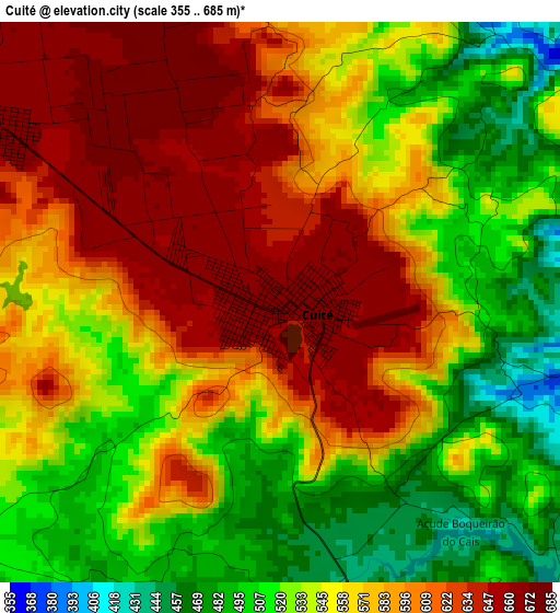
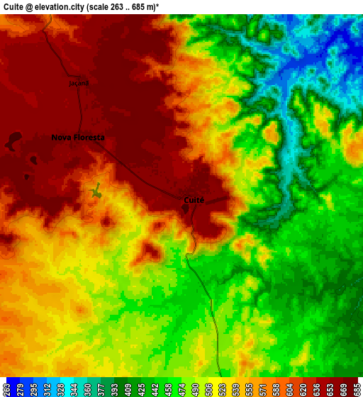
Below is the Elevation map of Cuité, which displays elevation range with different colors. Scale of the first map is from 355 to 685 m (1165 to 2247 ft) with average elevation of 564.1 meters (=1851 ft) [note 1]
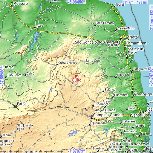
These maps also provides idea of topography and contour of this city, they are displayed at different zoom levels. More info about maps, scale and edge coordinates you can find below images.
| \ | Map #1 | Map #2 | Topo.Map |
| Scale [m] | 355..685 m | 263..685 m | × |
| Scale [ft] | 1165..2247 ft | 863..2247 ft | × |
| Average | 564.1 m = 1851 ft | 524.5 m = 1721 ft | × |
| Width | 9.71 km = 6 mi | 19.42 km = 12.1 mi | 310.7 km = 193.1 mi |
| Height | 9.71 km = 6 mi | 19.42 km = 12.1 mi | 310.7 km = 193.1 mi |
| ↑Max Latitude | -6.439944° | -6.396274° | -5.08456° |
| Latitude at center | -6.48361° | -6.48361° | -6.48361° |
| ↓Min Latitude | -6.527272° | -6.570931° | -7.87879° |
| ← Min Longitude | -36.197555° | -36.241501° | -37.55986° |
| Longitude center | -36.15361° | -36.15361° | -36.15361° |
| →Max Longitude | -36.109665° | -36.065719° | -34.74736° |
Nearby cities:
Cities around Cuité sort by population:
• Currais Novos elevation 361 m
47.3 km,  301°
301°
• Santa Cruz 230 m
31.7 km,  27°
27°
• Picuí 445 m
21.6 km,  262°
262°
• São José do Campestre 153 m
52.1 km,  68°
68°
• Nova Floresta 670 m
6.3 km, 299°
• Tangará 188 m
50.1 km,  50°
50°
• Araruna 496 m
46.3 km,  100°
100°
• Arara 461 m
58.1 km,  131°
131°
• Cacimba de Dentro 529 m
43.8 km,  113°
113°
• São Tomé 167 m
57.5 km,  8°
8°
• Lagoa Nova 697 m
56.1 km,  319°
319°
• Cerro Corá 573 m
53.1 km,  336°
336°
Multilingual:
 En español:
Cuité elevación 670 m.
 En France:
Cuité élévation 670 m.


Sources and notes:
- [note 1] Map square and city borders are not equal. Map elevation data is calculated only from area inside that square.
- [src 1] Elevation data from geonames database provided with same terms of usage.
- [src 2] The elevation map of Cuité is generated using elevation data from NASA's 3 arcsec (90m) resolution SRTM data.
- [src 3] Base (background) map © OpenStreetMap contributors tiles are generated by Geofabrik and OpenTopoMap.
Copyright & License:
This Cuité Elevation Map is licensed under CC BY-SA. You may reuse any part from this page, if you give a proper credit by linking to this URL:
 More info on terms of use page.