Urbano Santos elevation
Urbano Santos (Maranhão), Brazil elevation is 42 meters and Urbano Santos elevation in feet is 138 ft above sea level [src 1]. Urbano Santos is a populated place (feature code) with elevation that is 340 meters (1115 ft) smaller than average city elevation in Brazil.
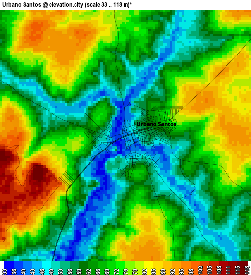
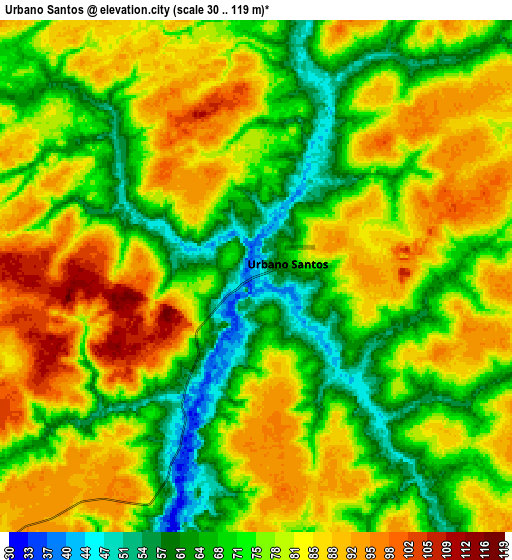
Below is the Elevation map of Urbano Santos, which displays elevation range with different colors. Scale of the first map is from 33 to 118 m (108 to 387 ft) with average elevation of 68.9 meters (=226 ft) [note 1]
These maps also provides idea of topography and contour of this city, they are displayed at different zoom levels. More info about maps, scale and edge coordinates you can find below images.
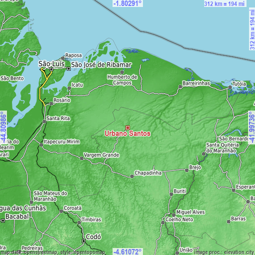
| \ | Map #1 | Map #2 | Topo.Map |
| Scale [m] | 33..118 m | 30..119 m | × |
| Scale [ft] | 108..387 ft | 98..390 ft | × |
| Average | 68.9 m = 226 ft | 77.2 m = 253 ft | × |
| Width | 9.76 km = 6.1 mi | 19.51 km = 12.1 mi | 312.2 km = 194 mi |
| Height | 9.76 km = 6.1 mi | 19.51 km = 12.1 mi | 312.2 km = 194 mi |
| ↑Max Latitude | -3.163903° | -3.120023° | -1.80291° |
| Latitude at center | -3.20778° | -3.20778° | -3.20778° |
| ↓Min Latitude | -3.251656° | -3.295529° | -4.61072° |
| ← Min Longitude | -43.447555° | -43.491501° | -44.80986° |
| Longitude center | -43.40361° | -43.40361° | -43.40361° |
| →Max Longitude | -43.359665° | -43.315719° | -41.99736° |
Nearby cities:
Cities around Urbano Santos sort by population:
• Chapadinha elevation 109 m
59.6 km,  175°
175°
• São José de Ribamar 18 m
101.9 km,  314°
314°
• Vargem Grande 44 m
68 km,  236°
236°
• Barreirinhas 5 m
81.5 km,  51°
51°
• Santa Quitéria do Maranhão 29 m
101.1 km,  109°
109°
• Santa Rita 44 m
88.8 km,  214°
214°
• São Benedito do Rio Preto 34 m
19.7 km,  224°
224°
• Brejo 70 m
89.8 km,  126°
126°
• Pirapemas 36 m
107.7 km, 237°
• Humberto de Campos 14 m
68.1 km,  354°
354°
• Icatu 8 m
87.8 km,  303°
303°
• Atins 3 m
102.1 km, 46°
Multilingual:
 En español:
Urbano Santos elevación 42 m.
 En France:
Urbano Santos élévation 42 m.
 Auf Deutsch:
Urbano Santos höhe über dem Meeresspiegel ist 42 m.

Sources and notes:
- [note 1] Map square and city borders are not equal. Map elevation data is calculated only from area inside that square.
- [src 1] Elevation data from geonames database provided with same terms of usage.
- [src 2] The elevation map of Urbano Santos is generated using elevation data from NASA's 3 arcsec (90m) resolution SRTM data.
- [src 3] Base (background) map © OpenStreetMap contributors tiles are generated by Geofabrik and OpenTopoMap.
Copyright & License:
This Urbano Santos Elevation Map is licensed under CC BY-SA. You may reuse any part from this page, if you give a proper credit by linking to this URL:
 More info on terms of use page.