Icatu elevation
Icatu (Maranhão), Brazil elevation is 8 meters and Icatu elevation in feet is 26 ft above sea level [src 1]. Icatu is a populated place (feature code) with elevation that is 374 meters (1227 ft) smaller than average city elevation in Brazil.
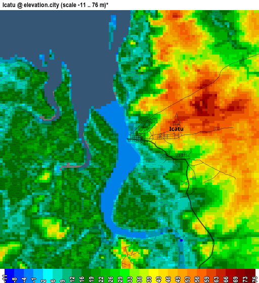
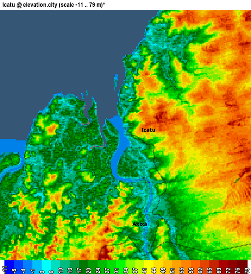
Below is the Elevation map of Icatu, which displays elevation range with different colors. Scale of the first map is from -11 to 76 m (-36 to 249 ft) with average elevation of 25.8 meters (=85 ft) [note 1]
These maps also provides idea of topography and contour of this city, they are displayed at different zoom levels. More info about maps, scale and edge coordinates you can find below images.
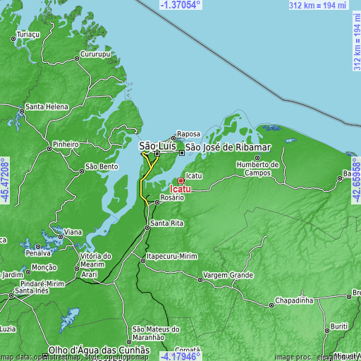
| \ | Map #1 | Map #2 | Topo.Map |
| Scale [m] | -11..76 m | -11..79 m | × |
| Scale [ft] | -36..249 ft | -36..259 ft | × |
| Average | 25.8 m = 85 ft | 33 m = 108 ft | × |
| Width | 9.76 km = 6.1 mi | 19.52 km = 12.1 mi | 312.3 km = 194.1 mi |
| Height | 9.76 km = 6.1 mi | 19.52 km = 12.1 mi | 312.4 km = 194.1 mi |
| ↑Max Latitude | -2.731935° | -2.688039° | -1.37054° |
| Latitude at center | -2.77583° | -2.77583° | -2.77583° |
| ↓Min Latitude | -2.819723° | -2.863614° | -4.17946° |
| ← Min Longitude | -44.109775° | -44.153721° | -45.47208° |
| Longitude center | -44.06583° | -44.06583° | -44.06583° |
| →Max Longitude | -44.021885° | -43.977939° | -42.65958° |
Nearby cities:
Cities around Icatu sort by population:
• São Luís elevation 29 m
38 km,  316°
316°
• Itapecuru Mirim 20 m
75.9 km,  205°
205°
• São José de Ribamar 18 m
23.8 km,  3°
3°
• Vargem Grande 44 m
86.9 km,  168°
168°
• São Bento 10 m
84.4 km,  276°
276°
• Urbano Santos 42 m
87.8 km,  123°
123°
• São Benedito do Rio Preto 34 m
86.1 km,  136°
136°
• Bequimão 15 m
87.5 km,  294°
294°
• Alcântara 32 m
56.8 km, 316°
• Anajatuba 11 m
82.1 km,  228°
228°
• Humberto de Campos 14 m
70 km,  73°
73°
• São João Batista 6 m
84.7 km,  256°
256°
Multilingual:
 En español:
Icatu elevación 8 m.
 En France:
Icatu élévation 8 m.


Sources and notes:
- [note 1] Map square and city borders are not equal. Map elevation data is calculated only from area inside that square.
- [src 1] Elevation data from geonames database provided with same terms of usage.
- [src 2] The elevation map of Icatu is generated using elevation data from NASA's 3 arcsec (90m) resolution SRTM data.
- [src 3] Base (background) map © OpenStreetMap contributors tiles are generated by Geofabrik and OpenTopoMap.
Copyright & License:
This Icatu Elevation Map is licensed under CC BY-SA. You may reuse any part from this page, if you give a proper credit by linking to this URL:
 More info on terms of use page.