San Pedro elevation
San Pedro (Santa Cruz), Bolivia elevation is 298 meters and San Pedro elevation in feet is 978 ft above sea level [src 1]. San Pedro is a populated place (feature code) with elevation that is 1578 meters (5177 ft) smaller than average city elevation in Bolivia.
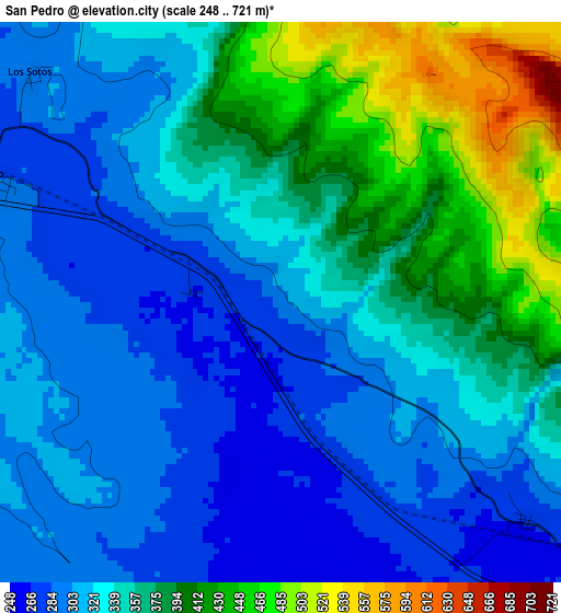
Below is the Elevation map of San Pedro, which displays elevation range with different colors. Scale of the first map is from 248 to 721 m (814 to 2365 ft) with average elevation of 346 meters (=1135 ft) [note 1]
These maps also provides idea of topography and contour of this city, they are displayed at different zoom levels. More info about maps, scale and edge coordinates you can find below images.
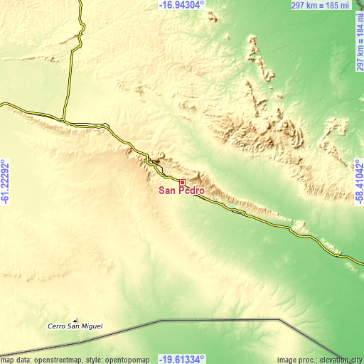
| \ | Map #1 | Topo.Map |
| Scale [m] | 248..721 m | × |
| Scale [ft] | 814..2365 ft | × |
| Average | 346 m = 1135 ft | × |
| Width | 9.28 km = 5.8 mi | 296.9 km = 184.5 mi |
| Height | 9.28 km = 5.8 mi | 296.9 km = 184.5 mi |
| ↑Max Latitude | -18.241598° | -16.94304° |
| Latitude at center | -18.28333° | -18.28333° |
| ↓Min Latitude | -18.325052° | -19.61334° |
| ← Min Longitude | -59.860615° | -61.22292° |
| Longitude center | -59.81667° | -59.81667° |
| →Max Longitude | -59.772725° | -58.41042° |
Nearby cities:
Cities around San Pedro sort by population:
• San Ignacio de Velasco elevation 385 m
244.7 km,  330°
330°
• Puerto Quijarro 92 m
223.8 km,  75°
75°
• Roboré 258 m
8.2 km,  134°
134°
• Pailón 298 m
318.1 km,  282°
282°
• San Julian 332 m
327.2 km, 279°
• Concepción 478 m
235.6 km, 330°
• San Matías 120 m
260.8 km,  35°
35°
• Puesto de Pailas 297 m
323.3 km, 282°
• Paurito 361 m
335.9 km, 277°
• San Julian 339 m
329.8 km, 279°
• Cotoca 318 m
324.6 km, 280°
• Puearto Pailas 300 m
324.2 km, 282°
Multilingual:
 En español:
San Pedro elevación 298 m.
 En France:
San Pedro élévation 298 m.
 Auf Deutsch:
San Pedro höhe über dem Meeresspiegel ist 298 m.

Sources and notes:
- [note 1] Map square and city borders are not equal. Map elevation data is calculated only from area inside that square.
- [src 1] Elevation data from geonames database provided with same terms of usage.
- [src 2] The elevation map of San Pedro is generated using elevation data from NASA's 3 arcsec (90m) resolution SRTM data.
- [src 3] Base (background) map © OpenStreetMap contributors tiles are generated by Geofabrik and OpenTopoMap.
Copyright & License:
This San Pedro Elevation Map is licensed under CC BY-SA. You may reuse any part from this page, if you give a proper credit by linking to this URL:
 More info on terms of use page.