Pailón elevation
Pailón (Santa Cruz), Bolivia elevation is 298 meters and Pailón elevation in feet is 978 ft above sea level [src 1]. Pailón is a populated place (feature code) with elevation that is 1578 meters (5177 ft) smaller than average city elevation in Bolivia.
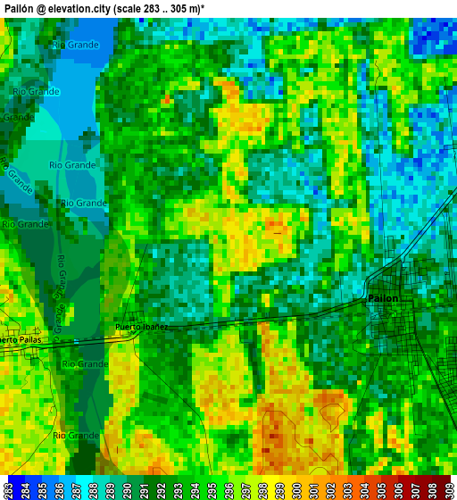
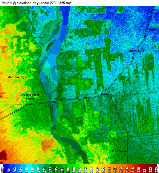
Below is the Elevation map of Pailón, which displays elevation range with different colors. Scale of the first map is from 283 to 305 m (928 to 1001 ft) with average elevation of 292.6 meters (=960 ft) [note 1]
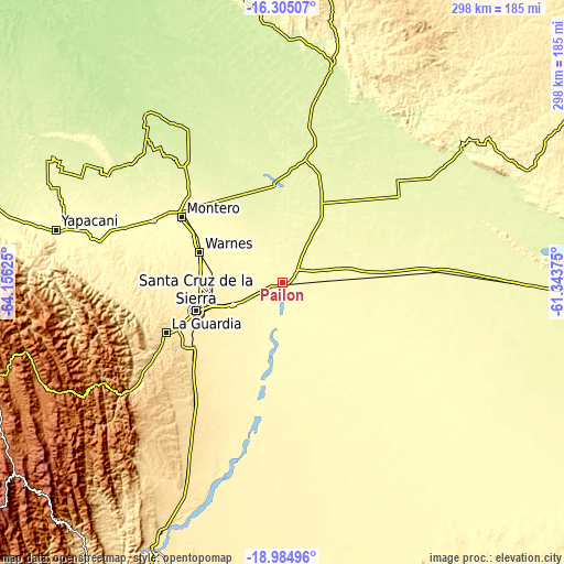
These maps also provides idea of topography and contour of this city, they are displayed at different zoom levels. More info about maps, scale and edge coordinates you can find below images.
| \ | Map #1 | Map #2 | Topo.Map |
| Scale [m] | 283..305 m | 279..325 m | × |
| Scale [ft] | 928..1001 ft | 915..1066 ft | × |
| Average | 292.6 m = 960 ft | 294.6 m = 967 ft | × |
| Width | 9.31 km = 5.8 mi | 18.63 km = 11.6 mi | 298 km = 185.2 mi |
| Height | 9.31 km = 5.8 mi | 18.63 km = 11.6 mi | 298 km = 185.2 mi |
| ↑Max Latitude | -17.608118° | -17.566227° | -16.30507° |
| Latitude at center | -17.65° | -17.65° | -17.65° |
| ↓Min Latitude | -17.691872° | -17.733734° | -18.98496° |
| ← Min Longitude | -62.793945° | -62.837891° | -64.15625° |
| Longitude center | -62.75° | -62.75° | -62.75° |
| →Max Longitude | -62.706055° | -62.662109° | -61.34375° |
Nearby cities:
Cities around Pailón sort by population:
• Santa Cruz de la Sierra elevation 433 m
48.1 km,  251°
251°
• Warnes 340 m
46.7 km,  288°
288°
• Cotoca 387 m
36.8 km,  239°
239°
• San Julian 332 m
19.3 km,  219°
219°
• La Bélgica 353 m
50.7 km,  282°
282°
• Okinawa Número Uno 260 m
46.9 km,  351°
351°
• Puesto de Pailas 297 m
5.3 km,  270°
270°
• Paurito 361 m
34.6 km, 221°
• Santa Fe 377 m
42 km,  226°
226°
• San Julian 339 m
23.2 km, 221°
• Cotoca 318 m
14.2 km, 218°
• Puearto Pailas 300 m
6.8 km,  257°
257°
Multilingual:
 En español:
Pailón elevación 298 m.
 En France:
Pailón élévation 298 m.


Sources and notes:
- [note 1] Map square and city borders are not equal. Map elevation data is calculated only from area inside that square.
- [src 1] Elevation data from geonames database provided with same terms of usage.
- [src 2] The elevation map of Pailón is generated using elevation data from NASA's 3 arcsec (90m) resolution SRTM data.
- [src 3] Base (background) map © OpenStreetMap contributors tiles are generated by Geofabrik and OpenTopoMap.
Copyright & License:
This Pailón Elevation Map is licensed under CC BY-SA. You may reuse any part from this page, if you give a proper credit by linking to this URL:
 More info on terms of use page.