Savalou elevation
Savalou (Collines), Benin elevation is 181 meters and Savalou elevation in feet is 594 ft above sea level [src 1]. Savalou is a seat of a first-order administrative division (feature code) with elevation that is 18 meters (59 ft) bigger than average city elevation in Benin.
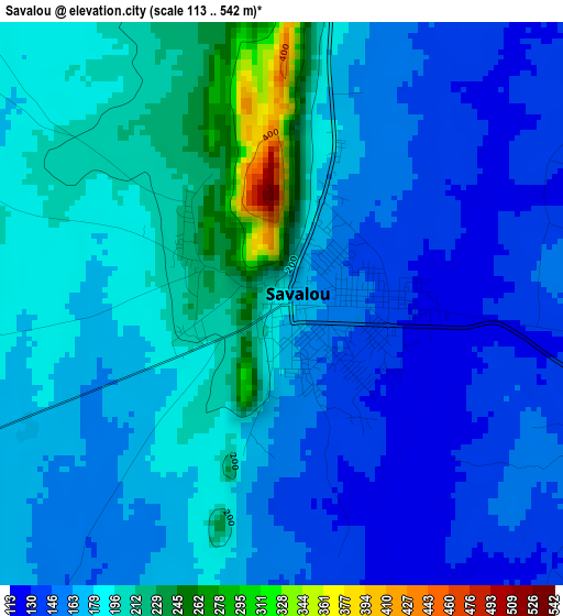
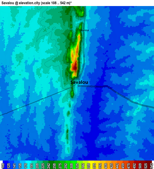
Below is the Elevation map of Savalou, which displays elevation range with different colors. Scale of the first map is from 113 to 542 m (371 to 1778 ft) with average elevation of 174.1 meters (=571 ft) [note 1]
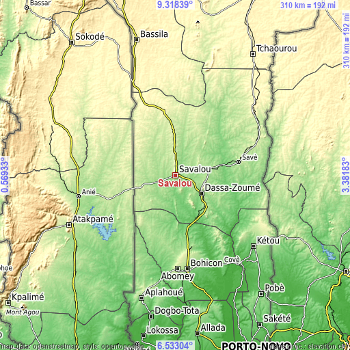
These maps also provides idea of topography and contour of this city, they are displayed at different zoom levels. More info about maps, scale and edge coordinates you can find below images.
| \ | Map #1 | Map #2 | Topo.Map |
| Scale [m] | 113..542 m | 108..542 m | × |
| Scale [ft] | 371..1778 ft | 354..1778 ft | × |
| Average | 174.1 m = 571 ft | 164.7 m = 540 ft | × |
| Width | 9.68 km = 6 mi | 19.36 km = 12 mi | 309.7 km = 192.4 mi |
| Height | 9.68 km = 6 mi | 19.36 km = 12 mi | 309.7 km = 192.4 mi |
| ↑Max Latitude | 7.971593° | 8.015111° | 9.31839° |
| Latitude at center | 7.92807° | 7.92807° | 7.92807° |
| ↓Min Latitude | 7.884542° | 7.84101° | 6.53304° |
| ← Min Longitude | 1.931635° | 1.887689° | 0.56933° |
| Longitude center | 1.97558° | 1.97558° | 1.97558° |
| →Max Longitude | 2.019525° | 2.063471° | 3.38183° |
Nearby cities:
Cities around Savalou sort by population:
• Bohicon elevation 166 m
84 km,  173°
173°
• Abomey 228 m
82.9 km,  178°
178°
• Savé 190 m
57.5 km,  78°
78°
• Dogbo 72 m
127.4 km,  189°
189°
• Cové 117 m
88.3 km,  152°
152°
• Bassila 388 m
124.8 km,  344°
344°
• Kétou 103 m
93.1 km,  132°
132°
• Dassa-Zoumé 156 m
30.3 km, 130°
• Tchaourou 332 m
126.6 km,  32°
32°
• Aplahoué 124 m
115.2 km,  196°
196°
• Ouinhi 37 m
109.3 km, 149°
• Zagnanado 108 m
90.6 km, 150°
Multilingual:
 En español:
Savalou elevación 181 m.
 En France:
Savalou élévation 181 m.


Sources and notes:
- [note 1] Map square and city borders are not equal. Map elevation data is calculated only from area inside that square.
- [src 1] Elevation data from geonames database provided with same terms of usage.
- [src 2] The elevation map of Savalou is generated using elevation data from NASA's 3 arcsec (90m) resolution SRTM data.
- [src 3] Base (background) map © OpenStreetMap contributors tiles are generated by Geofabrik and OpenTopoMap.
Copyright & License:
This Savalou Elevation Map is licensed under CC BY-SA. You may reuse any part from this page, if you give a proper credit by linking to this URL:
 More info on terms of use page.