Abomey elevation
Abomey (Zou), Benin elevation is 228 meters and Abomey elevation in feet is 748 ft above sea level [src 1]. Abomey is a seat of a first-order administrative division (feature code) with elevation that is 65 meters (213 ft) bigger than average city elevation in Benin.
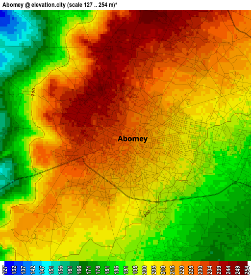
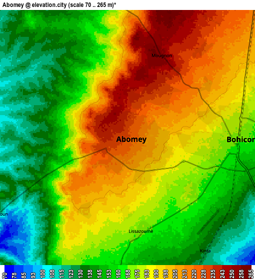
Below is the Elevation map of Abomey, which displays elevation range with different colors. Scale of the first map is from 127 to 254 m (417 to 833 ft) with average elevation of 207 meters (=679 ft) [note 1]
These maps also provides idea of topography and contour of this city, they are displayed at different zoom levels. More info about maps, scale and edge coordinates you can find below images.
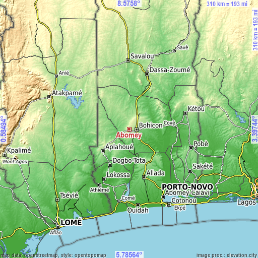
| \ | Map #1 | Map #2 | Topo.Map |
| Scale [m] | 127..254 m | 70..265 m | × |
| Scale [ft] | 417..833 ft | 230..869 ft | × |
| Average | 207 m = 679 ft | 174 m = 571 ft | × |
| Width | 9.7 km = 6 mi | 19.39 km = 12 mi | 310.2 km = 192.7 mi |
| Height | 9.7 km = 6 mi | 19.39 km = 12 mi | 310.3 km = 192.8 mi |
| ↑Max Latitude | 7.226458° | 7.270052° | 8.5758° |
| Latitude at center | 7.18286° | 7.18286° | 7.18286° |
| ↓Min Latitude | 7.139257° | 7.095651° | 5.78564° |
| ← Min Longitude | 1.947245° | 1.903299° | 0.58494° |
| Longitude center | 1.99119° | 1.99119° | 1.99119° |
| →Max Longitude | 2.035135° | 2.079081° | 3.39744° |
Nearby cities:
Cities around Abomey sort by population:
• Bohicon elevation 166 m
8.3 km,  93°
93°
• Dogbo 72 m
48.6 km,  208°
208°
• Cové 117 m
38.7 km,  83°
83°
• Dassa-Zoumé 156 m
66.5 km,  18°
18°
• Allada 93 m
60.2 km,  162°
162°
• Aplahoué 124 m
43.9 km,  230°
230°
• Hinvi 121 m
50.2 km, 157°
• Houinvigue 74 m
63.3 km,  121°
121°
• Avakpa 54 m
58.1 km,  174°
174°
• Ouinhi 37 m
55.4 km,  101°
101°
• Sé 119 m
49.3 km, 165°
• Zagnanado 108 m
43.5 km, 84°
Multilingual:
 En español:
Abomey elevación 228 m.
 En France:
Abomey élévation 228 m.


Sources and notes:
- [note 1] Map square and city borders are not equal. Map elevation data is calculated only from area inside that square.
- [src 1] Elevation data from geonames database provided with same terms of usage.
- [src 2] The elevation map of Abomey is generated using elevation data from NASA's 3 arcsec (90m) resolution SRTM data.
- [src 3] Base (background) map © OpenStreetMap contributors tiles are generated by Geofabrik and OpenTopoMap.
Copyright & License:
This Abomey Elevation Map is licensed under CC BY-SA. You may reuse any part from this page, if you give a proper credit by linking to this URL:
 More info on terms of use page.