Kétou elevation
Kétou (Plateau, Commune of Ketou), Benin elevation is 103 meters and Kétou elevation in feet is 338 ft above sea level [src 1]. Kétou is a populated place (feature code) with elevation that is 60 meters (197 ft) smaller than average city elevation in Benin.
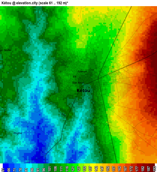
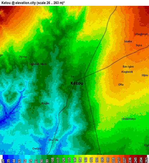
Below is the Elevation map of Kétou, which displays elevation range with different colors. Scale of the first map is from 61 to 192 m (200 to 630 ft) with average elevation of 116.6 meters (=383 ft) [note 1]
These maps also provides idea of topography and contour of this city, they are displayed at different zoom levels. More info about maps, scale and edge coordinates you can find below images.
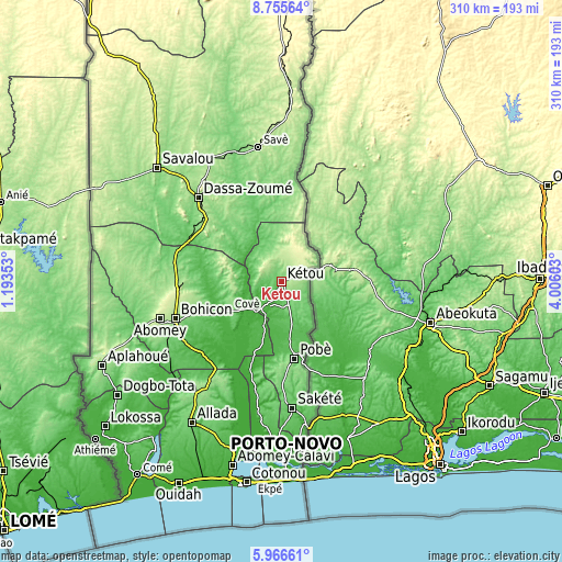
| \ | Map #1 | Map #2 | Topo.Map |
| Scale [m] | 61..192 m | 26..263 m | × |
| Scale [ft] | 200..630 ft | 85..863 ft | × |
| Average | 116.6 m = 383 ft | 130.4 m = 428 ft | × |
| Width | 9.69 km = 6 mi | 19.38 km = 12 mi | 310.1 km = 192.7 mi |
| Height | 9.69 km = 6 mi | 19.38 km = 12 mi | 310.1 km = 192.7 mi |
| ↑Max Latitude | 7.406901° | 7.450477° | 8.75564° |
| Latitude at center | 7.36332° | 7.36332° | 7.36332° |
| ↓Min Latitude | 7.319735° | 7.276146° | 5.96661° |
| ← Min Longitude | 2.555835° | 2.511889° | 1.19353° |
| Longitude center | 2.59978° | 2.59978° | 2.59978° |
| →Max Longitude | 2.643725° | 2.687671° | 4.00603° |
Nearby cities:
Cities around Kétou sort by population:
• Bohicon elevation 166 m
62.3 km,  250°
250°
• Abomey 228 m
70.1 km, 253°
• Savé 190 m
75.6 km,  350°
350°
• Cové 117 m
32.7 km,  241°
241°
• Pobé 136 m
43.2 km,  170°
170°
• Sakété 80 m
70 km, 174°
• Dassa-Zoumé 156 m
62.9 km,  313°
313°
• Banigbé 37 m
80.5 km, 171°
• Adjohon 29 m
73 km,  190°
190°
• Houinvigue 74 m
54.7 km, 193°
• Ouinhi 37 m
33.6 km,  202°
202°
• Zagnanado 108 m
28.6 km, 236°
Multilingual:
 En español:
Kétou elevación 103 m.
 En France:
Kétou élévation 103 m.


Sources and notes:
- [note 1] Map square and city borders are not equal. Map elevation data is calculated only from area inside that square.
- [src 1] Elevation data from geonames database provided with same terms of usage.
- [src 2] The elevation map of Kétou is generated using elevation data from NASA's 3 arcsec (90m) resolution SRTM data.
- [src 3] Base (background) map © OpenStreetMap contributors tiles are generated by Geofabrik and OpenTopoMap.
Copyright & License:
This Kétou Elevation Map is licensed under CC BY-SA. You may reuse any part from this page, if you give a proper credit by linking to this URL:
 More info on terms of use page.