Byala Slatina elevation
Byala Slatina (Vratsa, Obshtina Byala Slatina), Bulgaria elevation is 125 meters and Byala Slatina elevation in feet is 410 ft above sea level [src 1]. Byala Slatina is a populated place (feature code) with elevation that is 194 meters (636 ft) smaller than average city elevation in Bulgaria.
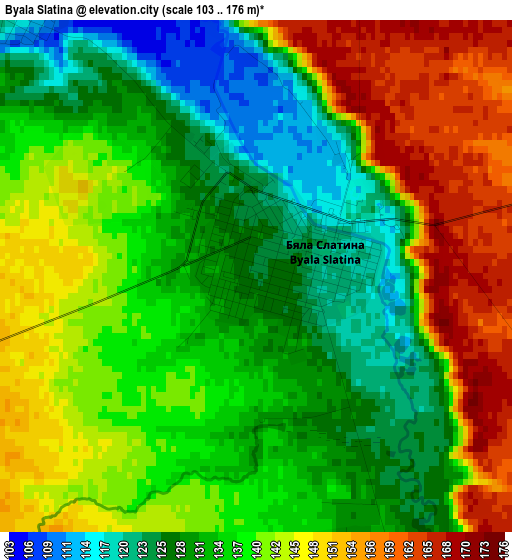
Below is the Elevation map of Byala Slatina, which displays elevation range with different colors. Scale of the first map is from 103 to 176 m (338 to 577 ft) with average elevation of 138.1 meters (=453 ft) [note 1]
These maps also provides idea of topography and contour of this city, they are displayed at different zoom levels. More info about maps, scale and edge coordinates you can find below images.
| \ | Map #1 | Map #2 | Topo.Map |
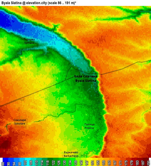
| Scale [m] | 103..176 m | 86..191 m | × |
| Scale [ft] | 338..577 ft | 282..627 ft | × |
| Average | 138.1 m = 453 ft | 148.7 m = 488 ft | × |
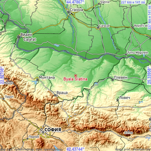
| Width | 7.09 km = 4.4 mi | 14.19 km = 8.8 mi | 227 km = 141.1 mi |
| Height | 7.09 km = 4.4 mi | 14.19 km = 8.8 mi | 227 km = 141.1 mi |
| ↑Max Latitude | 43.498556° | 43.530425° | 44.47867° |
| Latitude at center | 43.46667° | 43.46667° | 43.46667° |
| ↓Min Latitude | 43.434767° | 43.402848° | 42.43744° |
| ← Min Longitude | 23.889385° | 23.845439° | 22.52708° |
| Longitude center | 23.93333° | 23.93333° | 23.93333° |
| →Max Longitude | 23.977275° | 24.021221° | 25.33958° |
Nearby cities:
Cities around Byala Slatina sort by population:
• Cherven Bryag elevation 195 m
26 km,  148°
148°
• Kozloduy 41 m
38.7 km,  333°
333°
• Lukovit 136 m
35.1 km, 147°
• Knezha 116 m
12.7 km,  72°
72°
• Oryahovo 56 m
30 km,  4°
4°
• Iskar 110 m
27 km,  93°
93°
• Mizia 34 m
25.2 km,  345°
345°
• Krivodol 158 m
37.7 km,  254°
254°
• Roman 221 m
35.2 km,  182°
182°
• Borovan 189 m
15.3 km,  255°
255°
• Koynare 83 m
20.7 km,  128°
128°
• Hayredin 45 m
26.6 km,  304°
304°
Multilingual:
 En español:
Byala Slatina elevación 125 m.
 En France:
Byala Slatina élévation 125 m.
 Auf Deutsch:
Byala Slatina höhe über dem Meeresspiegel ist 125 m.

Sources and notes:
- [note 1] Map square and city borders are not equal. Map elevation data is calculated only from area inside that square.
- [src 1] Elevation data from geonames database provided with same terms of usage.
- [src 2] The elevation map of Byala Slatina is generated using elevation data from NASA's 3 arcsec (90m) resolution SRTM data.
- [src 3] Base (background) map © OpenStreetMap contributors tiles are generated by Geofabrik and OpenTopoMap.
Copyright & License:
This Byala Slatina Elevation Map is licensed under CC BY-SA. You may reuse any part from this page, if you give a proper credit by linking to this URL:
 More info on terms of use page.