Iskar elevation
Iskar (Pleven), Bulgaria elevation is 110 meters and Iskar elevation in feet is 361 ft above sea level [src 1]. Iskar is a populated place (feature code) with elevation that is 209 meters (686 ft) smaller than average city elevation in Bulgaria.
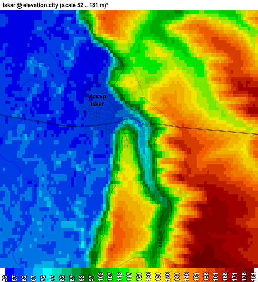
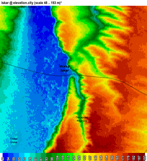
Below is the Elevation map of Iskar, which displays elevation range with different colors. Scale of the first map is from 52 to 181 m (171 to 594 ft) with average elevation of 104.5 meters (=343 ft) [note 1]
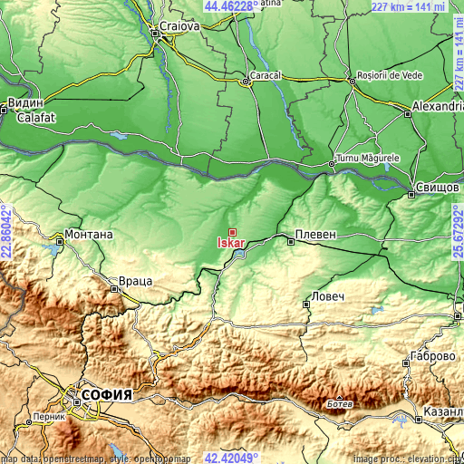
These maps also provides idea of topography and contour of this city, they are displayed at different zoom levels. More info about maps, scale and edge coordinates you can find below images.
| \ | Map #1 | Map #2 | Topo.Map |
| Scale [m] | 52..181 m | 48..193 m | × |
| Scale [ft] | 171..594 ft | 157..633 ft | × |
| Average | 104.5 m = 343 ft | 116 m = 381 ft | × |
| Width | 7.09 km = 4.4 mi | 14.19 km = 8.8 mi | 227 km = 141.1 mi |
| Height | 7.09 km = 4.4 mi | 14.19 km = 8.8 mi | 227 km = 141.1 mi |
| ↑Max Latitude | 43.481895° | 43.513773° | 44.46228° |
| Latitude at center | 43.45° | 43.45° | 43.45° |
| ↓Min Latitude | 43.418088° | 43.38616° | 42.42049° |
| ← Min Longitude | 24.222725° | 24.178779° | 22.86042° |
| Longitude center | 24.26667° | 24.26667° | 24.26667° |
| →Max Longitude | 24.310615° | 24.354561° | 25.67292° |
Nearby cities:
Cities around Iskar sort by population:
• Pleven elevation 97 m
28.5 km,  97°
97°
• Cherven Bryag 195 m
24.4 km,  213°
213°
• Byala Slatina 125 m
27 km,  273°
273°
• Lukovit 136 m
29 km,  196°
196°
• Knezha 116 m
15.8 km,  290°
290°
• Oryahovo 56 m
40.3 km,  322°
322°
• Dolni Dabnik 109 m
14.6 km,  112°
112°
• Gulyantsi 37 m
40.4 km,  58°
58°
• Dolna Mitropolia 57 m
21.6 km,  85°
85°
• Ugarchin 267 m
40.8 km,  162°
162°
• Koynare 83 m
15.5 km,  224°
224°
• Iskar 50 m
28.7 km,  31°
31°
Multilingual:
 En español:
Iskar elevación 110 m.
 En France:
Iskar élévation 110 m.


Sources and notes:
- [note 1] Map square and city borders are not equal. Map elevation data is calculated only from area inside that square.
- [src 1] Elevation data from geonames database provided with same terms of usage.
- [src 2] The elevation map of Iskar is generated using elevation data from NASA's 3 arcsec (90m) resolution SRTM data.
- [src 3] Base (background) map © OpenStreetMap contributors tiles are generated by Geofabrik and OpenTopoMap.
Copyright & License:
This Iskar Elevation Map is licensed under CC BY-SA. You may reuse any part from this page, if you give a proper credit by linking to this URL:
 More info on terms of use page.