Maglizh elevation
Maglizh (Stara Zagora, Obshtina Maglizh), Bulgaria elevation is 353 meters and Maglizh elevation in feet is 1158 ft above sea level [src 1]. Maglizh is a populated place (feature code) with elevation that is 34 meters (112 ft) bigger than average city elevation in Bulgaria.
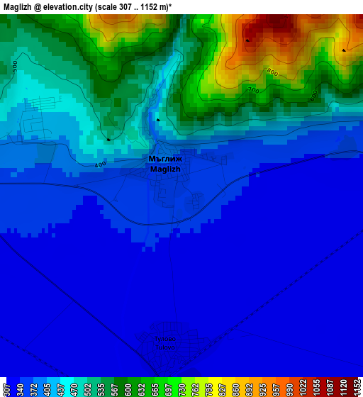
Below is the Elevation map of Maglizh, which displays elevation range with different colors. Scale of the first map is from 307 to 1152 m (1007 to 3780 ft) with average elevation of 433.3 meters (=1422 ft) [note 1]
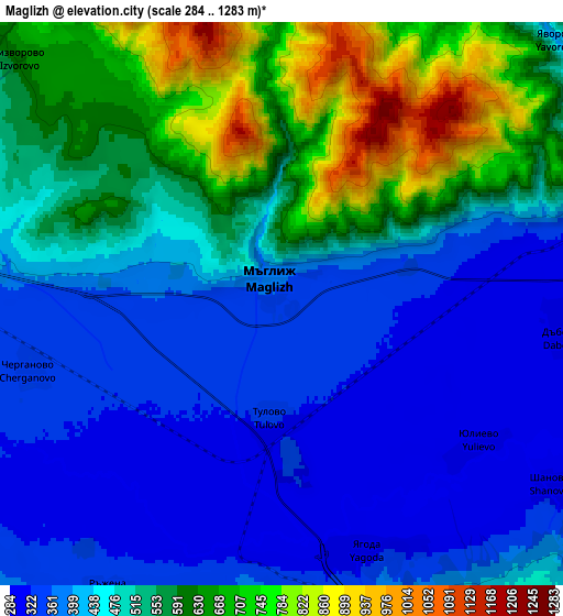
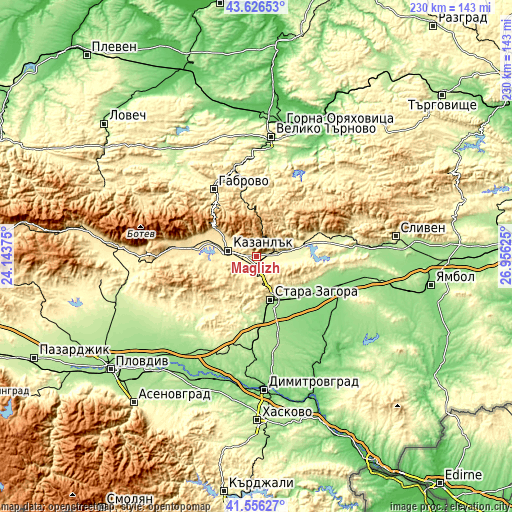
These maps also provides idea of topography and contour of this city, they are displayed at different zoom levels. More info about maps, scale and edge coordinates you can find below images.
| \ | Map #1 | Map #2 | Topo.Map |
| Scale [m] | 307..1152 m | 284..1283 m | × |
| Scale [ft] | 1007..3780 ft | 932..4209 ft | × |
| Average | 433.3 m = 1422 ft | 493 m = 1617 ft | × |
| Width | 7.19 km = 4.5 mi | 14.39 km = 8.9 mi | 230.2 km = 143 mi |
| Height | 7.19 km = 4.5 mi | 14.39 km = 8.9 mi | 230.2 km = 143 mi |
| ↑Max Latitude | 42.63234° | 42.664662° | 43.62653° |
| Latitude at center | 42.6° | 42.6° | 42.6° |
| ↓Min Latitude | 42.567644° | 42.53527° | 41.55627° |
| ← Min Longitude | 25.506055° | 25.462109° | 24.14375° |
| Longitude center | 25.55° | 25.55° | 25.55° |
| →Max Longitude | 25.593945° | 25.637891° | 26.95625° |
Nearby cities:
Cities around Maglizh sort by population:
• Stara Zagora elevation 205 m
20.1 km,  157°
157°
• Gabrovo 538 m
35.3 km,  330°
330°
• Kazanlak 366 m
12.4 km,  278°
278°
• Nova Zagora 130 m
40.4 km,  108°
108°
• Tryavna 488 m
29.9 km,  352°
352°
• Tvarditsa 350 m
30.7 km,  68°
68°
• Pavel Banya 411 m
28.6 km,  270°
270°
• Nikolaevo 277 m
20.8 km,  79°
79°
• Gurkovo 375 m
21.8 km, 70°
• Shipka 692 m
22 km,  306°
306°
• Asen 470 m
29.2 km, 280°
• Elkhovo 359 m
25.9 km,  201°
201°
Multilingual:
 En español:
Maglizh elevación 353 m.
 En France:
Maglizh élévation 353 m.


Sources and notes:
- [note 1] Map square and city borders are not equal. Map elevation data is calculated only from area inside that square.
- [src 1] Elevation data from geonames database provided with same terms of usage.
- [src 2] The elevation map of Maglizh is generated using elevation data from NASA's 3 arcsec (90m) resolution SRTM data.
- [src 3] Base (background) map © OpenStreetMap contributors tiles are generated by Geofabrik and OpenTopoMap.
Copyright & License:
This Maglizh Elevation Map is licensed under CC BY-SA. You may reuse any part from this page, if you give a proper credit by linking to this URL:
 More info on terms of use page.