Tvarditsa elevation
Tvarditsa (Sliven, Obshtina Tvarditsa), Bulgaria elevation is 350 meters and Tvarditsa elevation in feet is 1148 ft above sea level [src 1]. Tvarditsa is a populated place (feature code) with elevation that is 31 meters (102 ft) bigger than average city elevation in Bulgaria.
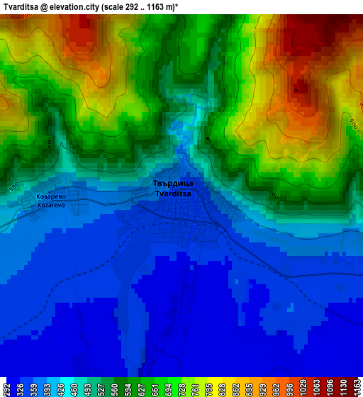
Below is the Elevation map of Tvarditsa, which displays elevation range with different colors. Scale of the first map is from 292 to 1163 m (958 to 3816 ft) with average elevation of 533.3 meters (=1750 ft) [note 1]
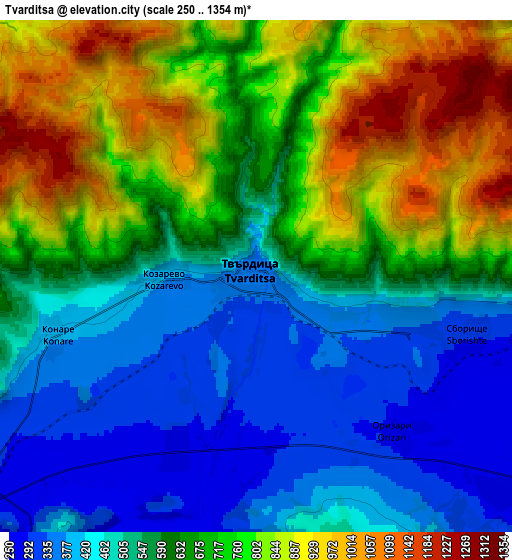
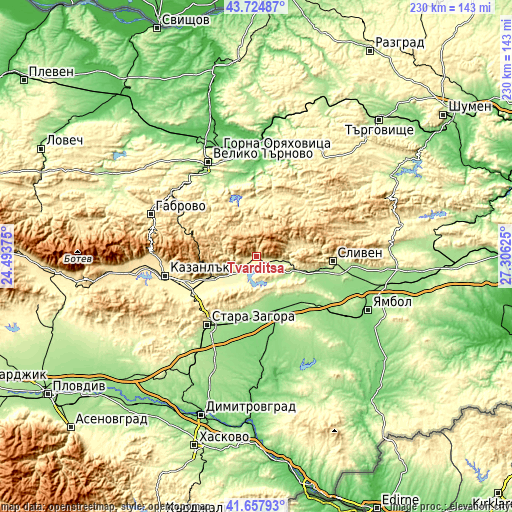
These maps also provides idea of topography and contour of this city, they are displayed at different zoom levels. More info about maps, scale and edge coordinates you can find below images.
| \ | Map #1 | Map #2 | Topo.Map |
| Scale [m] | 292..1163 m | 250..1354 m | × |
| Scale [ft] | 958..3816 ft | 820..4442 ft | × |
| Average | 533.3 m = 1750 ft | 625.5 m = 2052 ft | × |
| Width | 7.18 km = 4.5 mi | 14.36 km = 8.9 mi | 229.8 km = 142.8 mi |
| Height | 7.18 km = 4.5 mi | 14.36 km = 8.9 mi | 229.8 km = 142.8 mi |
| ↑Max Latitude | 42.732288° | 42.764559° | 43.72487° |
| Latitude at center | 42.7° | 42.7° | 42.7° |
| ↓Min Latitude | 42.667696° | 42.635374° | 41.65793° |
| ← Min Longitude | 25.856055° | 25.812109° | 24.49375° |
| Longitude center | 25.9° | 25.9° | 25.9° |
| →Max Longitude | 25.943945° | 25.987891° | 27.30625° |
Nearby cities:
Cities around Tvarditsa sort by population:
• Stara Zagora elevation 205 m
36.5 km,  215°
215°
• Sliven 271 m
35.1 km,  92°
92°
• Kazanlak 366 m
41.9 km,  257°
257°
• Nova Zagora 130 m
25.9 km,  158°
158°
• Tryavna 488 m
37.5 km,  299°
299°
• Elena 308 m
26 km,  357°
357°
• Maglizh 353 m
30.7 km,  248°
248°
• Nikolaevo 277 m
11 km,  227°
227°
• Gurkovo 375 m
9 km, 245°
• Kilifarevo 268 m
38.3 km,  325°
325°
• Zlataritsa 130 m
38.9 km,  0°
0°
• Kermen 169 m
36.3 km,  127°
127°
Multilingual:
 En español:
Tvarditsa elevación 350 m.
 En France:
Tvarditsa élévation 350 m.
 Auf Deutsch:
Tvarditsa höhe über dem Meeresspiegel ist 350 m.

Sources and notes:
- [note 1] Map square and city borders are not equal. Map elevation data is calculated only from area inside that square.
- [src 1] Elevation data from geonames database provided with same terms of usage.
- [src 2] The elevation map of Tvarditsa is generated using elevation data from NASA's 3 arcsec (90m) resolution SRTM data.
- [src 3] Base (background) map © OpenStreetMap contributors tiles are generated by Geofabrik and OpenTopoMap.
Copyright & License:
This Tvarditsa Elevation Map is licensed under CC BY-SA. You may reuse any part from this page, if you give a proper credit by linking to this URL:
 More info on terms of use page.