Saedinenie elevation
Saedinenie (Plovdiv, Obshtina Saedinenie), Bulgaria elevation is 203 meters and Saedinenie elevation in feet is 666 ft above sea level [src 1]. Saedinenie is a populated place (feature code) with elevation that is 116 meters (381 ft) smaller than average city elevation in Bulgaria.
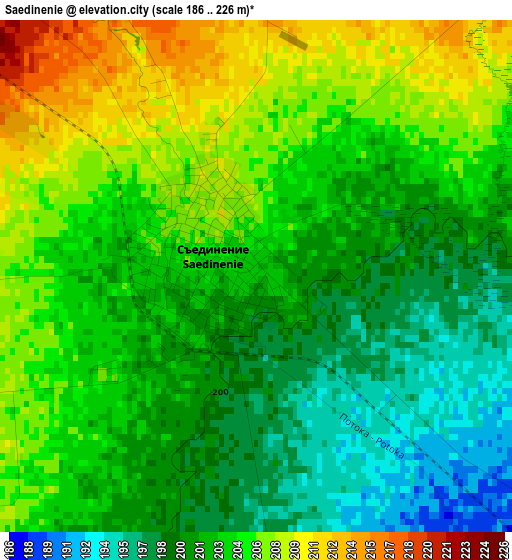
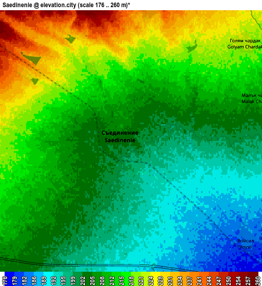
Below is the Elevation map of Saedinenie, which displays elevation range with different colors. Scale of the first map is from 186 to 226 m (610 to 741 ft) with average elevation of 203 meters (=666 ft) [note 1]
These maps also provides idea of topography and contour of this city, they are displayed at different zoom levels. More info about maps, scale and edge coordinates you can find below images.
| \ | Map #1 | Map #2 | Topo.Map |
| Scale [m] | 186..226 m | 176..260 m | × |
| Scale [ft] | 610..741 ft | 577..853 ft | × |
| Average | 203 m = 666 ft | 208.7 m = 685 ft | × |
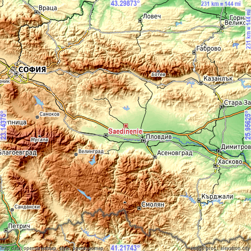
| Width | 7.23 km = 4.5 mi | 14.46 km = 9 mi | 231.4 km = 143.8 mi |
| Height | 7.23 km = 4.5 mi | 14.46 km = 9 mi | 231.4 km = 143.8 mi |
| ↑Max Latitude | 42.299182° | 42.331677° | 43.29873° |
| Latitude at center | 42.26667° | 42.26667° | 42.26667° |
| ↓Min Latitude | 42.234141° | 42.201595° | 41.21743° |
| ← Min Longitude | 24.506055° | 24.462109° | 23.14375° |
| Longitude center | 24.55° | 24.55° | 24.55° |
| →Max Longitude | 24.593945° | 24.637891° | 25.95625° |
Nearby cities:
Cities around Saedinenie sort by population:
• Plovdiv elevation 169 m
21 km,  128°
128°
• Pazardzhik 213 m
19.3 km,  247°
247°
• Peshtera 440 m
33.1 km,  218°
218°
• Rakovski 162 m
32.2 km,  88°
88°
• Stamboliyski 188 m
14.9 km,  185°
185°
• Septemvri 235 m
35.2 km,  259°
259°
• Krichim 228 m
25.1 km,  195°
195°
• Hisarya 364 m
28.7 km,  25°
25°
• Perushtitsa 407 m
24.1 km,  180°
180°
• Bratsigovo 572 m
31.6 km,  208°
208°
• Strelcha 511 m
32.3 km,  323°
323°
• Kaloyanovo 219 m
17.7 km,  58°
58°
Multilingual:
 En español:
Saedinenie elevación 203 m.
 En France:
Saedinenie élévation 203 m.
 Auf Deutsch:
Saedinenie höhe über dem Meeresspiegel ist 203 m.

Sources and notes:
- [note 1] Map square and city borders are not equal. Map elevation data is calculated only from area inside that square.
- [src 1] Elevation data from geonames database provided with same terms of usage.
- [src 2] The elevation map of Saedinenie is generated using elevation data from NASA's 3 arcsec (90m) resolution SRTM data.
- [src 3] Base (background) map © OpenStreetMap contributors tiles are generated by Geofabrik and OpenTopoMap.
Copyright & License:
This Saedinenie Elevation Map is licensed under CC BY-SA. You may reuse any part from this page, if you give a proper credit by linking to this URL:
 More info on terms of use page.