Valchedram elevation
Valchedram (Montana, Obshtina Valchedram), Bulgaria elevation is 65 meters and Valchedram elevation in feet is 213 ft above sea level [src 1]. Valchedram is a seat of a second-order administrative division (feature code) with elevation that is 254 meters (833 ft) smaller than average city elevation in Bulgaria.
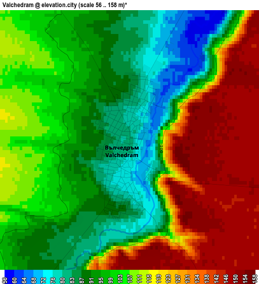
Below is the Elevation map of Valchedram, which displays elevation range with different colors. Scale of the first map is from 56 to 158 m (184 to 518 ft) with average elevation of 107.4 meters (=352 ft) [note 1]
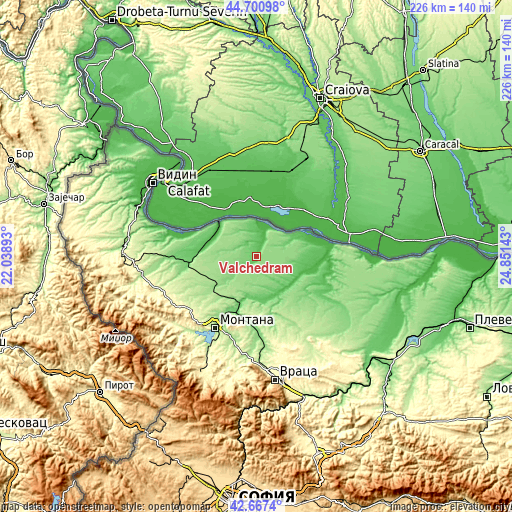
These maps also provides idea of topography and contour of this city, they are displayed at different zoom levels. More info about maps, scale and edge coordinates you can find below images.

| \ | Map #1 | Map #2 | Topo.Map |
| Scale [m] | 56..158 m | 42..161 m | × |
| Scale [ft] | 184..518 ft | 138..528 ft | × |
| Average | 107.4 m = 352 ft | 119.8 m = 393 ft | × |
| Width | 7.07 km = 4.4 mi | 14.13 km = 8.8 mi | 226.1 km = 140.5 mi |
| Height | 7.07 km = 4.4 mi | 14.13 km = 8.8 mi | 226.1 km = 140.5 mi |
| ↑Max Latitude | 43.724576° | 43.756326° | 44.70098° |
| Latitude at center | 43.69281° | 43.69281° | 43.69281° |
| ↓Min Latitude | 43.661027° | 43.629227° | 42.6674° |
| ← Min Longitude | 23.401235° | 23.357289° | 22.03893° |
| Longitude center | 23.44518° | 23.44518° | 23.44518° |
| →Max Longitude | 23.489125° | 23.533071° | 24.85143° |
Nearby cities:
Cities around Valchedram sort by population:
• Montana elevation 148 m
35.9 km,  209°
209°
• Lom 23 m
22 km,  310°
310°
• Kozloduy 41 m
24.1 km,  66°
66°
• Mizia 34 m
32.9 km,  91°
91°
• Krivodol 158 m
35.5 km,  174°
174°
• Borovan 189 m
37.9 km,  139°
139°
• Medkovets 172 m
23.5 km,  251°
251°
• Yakimovo 97 m
9.8 km,  228°
228°
• Hayredin 45 m
20.1 km,  120°
120°
• Boychinovtsi 105 m
26.1 km,  199°
199°
• Brusartsi 99 m
30.6 km,  263°
263°
• Drenovets 123 m
37.9 km,  269°
269°
Multilingual:
 En español:
Valchedram elevación 65 m.
 En France:
Valchedram élévation 65 m.
 Auf Deutsch:
Valchedram höhe über dem Meeresspiegel ist 65 m.

Sources and notes:
- [note 1] Map square and city borders are not equal. Map elevation data is calculated only from area inside that square.
- [src 1] Elevation data from geonames database provided with same terms of usage.
- [src 2] The elevation map of Valchedram is generated using elevation data from NASA's 3 arcsec (90m) resolution SRTM data.
- [src 3] Base (background) map © OpenStreetMap contributors tiles are generated by Geofabrik and OpenTopoMap.
Copyright & License:
This Valchedram Elevation Map is licensed under CC BY-SA. You may reuse any part from this page, if you give a proper credit by linking to this URL:
 More info on terms of use page.