Lom elevation
Lom (Montana, Obshtina Lom), Bulgaria elevation is 23 meters and Lom elevation in feet is 75 ft above sea level [src 1]. Lom is a seat of a second-order administrative division (feature code) with elevation that is 296 meters (971 ft) smaller than average city elevation in Bulgaria.
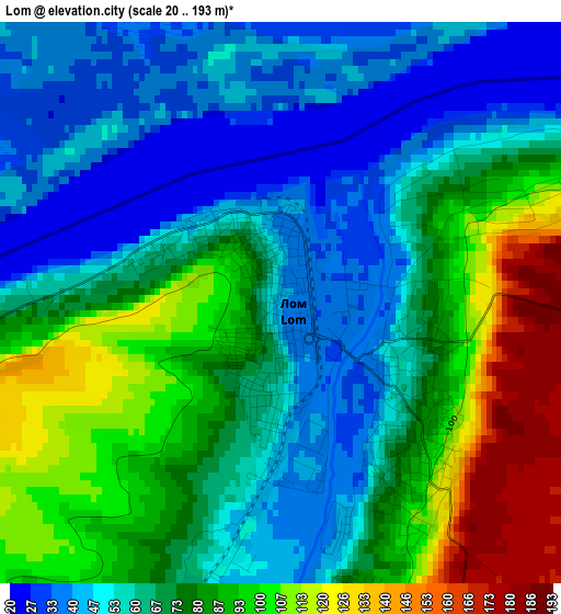
Below is the Elevation map of Lom, which displays elevation range with different colors. Scale of the first map is from 20 to 193 m (66 to 633 ft) with average elevation of 72.1 meters (=237 ft) [note 1]
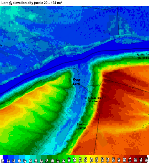
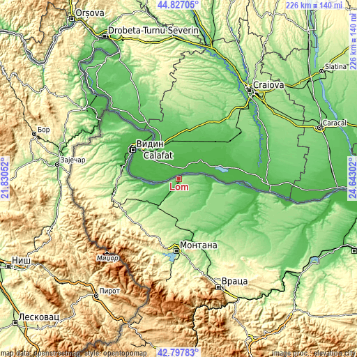
These maps also provides idea of topography and contour of this city, they are displayed at different zoom levels. More info about maps, scale and edge coordinates you can find below images.
| \ | Map #1 | Map #2 | Topo.Map |
| Scale [m] | 20..193 m | 20..194 m | × |
| Scale [ft] | 66..633 ft | 66..636 ft | × |
| Average | 72.1 m = 237 ft | 80 m = 262 ft | × |
| Width | 7.05 km = 4.4 mi | 14.1 km = 8.8 mi | 225.6 km = 140.2 mi |
| Height | 7.05 km = 4.4 mi | 14.1 km = 8.8 mi | 225.6 km = 140.2 mi |
| ↑Max Latitude | 43.852758° | 43.88444° | 44.82705° |
| Latitude at center | 43.82106° | 43.82106° | 43.82106° |
| ↓Min Latitude | 43.789345° | 43.757613° | 42.79783° |
| ← Min Longitude | 23.192825° | 23.148879° | 21.83052° |
| Longitude center | 23.23677° | 23.23677° | 23.23677° |
| →Max Longitude | 23.280715° | 23.324661° | 24.64302° |
Nearby cities:
Cities around Lom sort by population:
• Vidin elevation 35 m
34.1 km,  303°
303°
• Kozloduy 41 m
39.1 km,  96°
96°
• Valchedram 65 m
22 km,  130°
130°
• Dunavtsi 41 m
35.1 km,  288°
288°
• Medkovets 172 m
22.6 km,  194°
194°
• Yakimovo 97 m
22.7 km,  155°
155°
• Hayredin 45 m
41.9 km, 125°
• Boychinovtsi 105 m
39.6 km,  168°
168°
• Brusartsi 99 m
22.4 km,  217°
217°
• Dimovo 128 m
41.9 km,  257°
257°
• Ruzhintsi 188 m
39.3 km,  235°
235°
• Drenovets 123 m
25.6 km, 235°
Multilingual:
 En español:
Lom elevación 23 m.
 En France:
Lom élévation 23 m.


Sources and notes:
- [note 1] Map square and city borders are not equal. Map elevation data is calculated only from area inside that square.
- [src 1] Elevation data from geonames database provided with same terms of usage.
- [src 2] The elevation map of Lom is generated using elevation data from NASA's 3 arcsec (90m) resolution SRTM data.
- [src 3] Base (background) map © OpenStreetMap contributors tiles are generated by Geofabrik and OpenTopoMap.
Copyright & License:
This Lom Elevation Map is licensed under CC BY-SA. You may reuse any part from this page, if you give a proper credit by linking to this URL:
 More info on terms of use page.