Jablanica elevation
Jablanica (Federation of B&H), Bosnia and Herzegovina elevation is 199 meters and Jablanica elevation in feet is 653 ft above sea level [src 1]. Jablanica is a seat of a third-order administrative division (feature code) with elevation that is 164 meters (538 ft) smaller than average city elevation in Bosnia and Herzegovina.
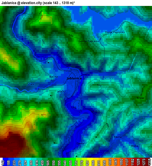
Below is the Elevation map of Jablanica, which displays elevation range with different colors. Scale of the first map is from 143 to 1318 m (469 to 4324 ft) with average elevation of 420.5 meters (=1380 ft) [note 1]
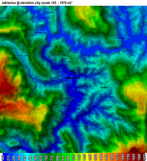
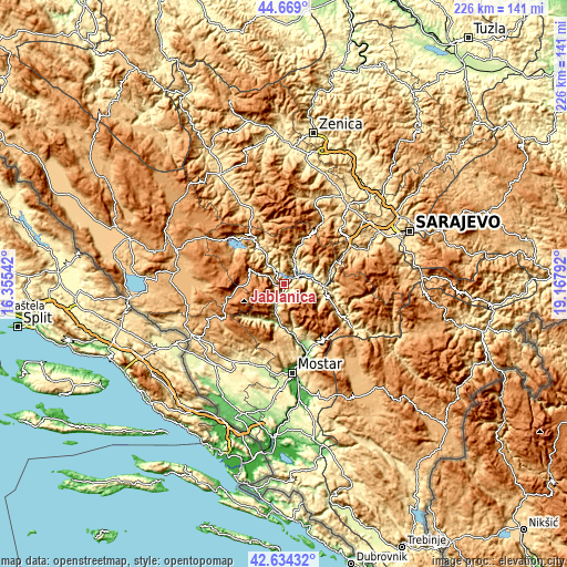
These maps also provides idea of topography and contour of this city, they are displayed at different zoom levels. More info about maps, scale and edge coordinates you can find below images.
| \ | Map #1 | Map #2 | Topo.Map |
| Scale [m] | 143..1318 m | 143..1970 m | × |
| Scale [ft] | 469..4324 ft | 469..6463 ft | × |
| Average | 420.5 m = 1380 ft | 637.8 m = 2093 ft | × |
| Width | 7.07 km = 4.4 mi | 14.14 km = 8.8 mi | 226.2 km = 140.6 mi |
| Height | 7.07 km = 4.4 mi | 14.14 km = 8.8 mi | 226.2 km = 140.6 mi |
| ↑Max Latitude | 43.692064° | 43.72383° | 44.669° |
| Latitude at center | 43.66028° | 43.66028° | 43.66028° |
| ↓Min Latitude | 43.62848° | 43.596662° | 42.63432° |
| ← Min Longitude | 17.717725° | 17.673779° | 16.35542° |
| Longitude center | 17.76167° | 17.76167° | 17.76167° |
| →Max Longitude | 17.805615° | 17.849561° | 19.16792° |
Nearby cities:
Cities around Jablanica sort by population:
• Konjic elevation 286 m
16.1 km,  93°
93°
• Prozor 711 m
21.8 km,  325°
325°
• Široki Brijeg 281 m
33.7 km,  203°
203°
• Potoci 91 m
29.4 km,  161°
161°
• Gornji Vakuf 671 m
33.9 km,  335°
335°
• Cim 142 m
34.1 km,  177°
177°
• Rumboci 712 m
28.2 km,  312°
312°
• Voljevac 767 m
25.7 km, 341°
• Ilići 98 m
34.8 km, 179°
• Bijela 446 m
16.3 km,  110°
110°
• Polje-Bijela 339 m
17.2 km,  100°
100°
• Kreševo 607 m
32.1 km,  44°
44°
Multilingual:
 En español:
Jablanica elevación 199 m.
 En France:
Jablanica élévation 199 m.
 Auf Deutsch:
Jablanica höhe über dem Meeresspiegel ist 199 m.

Sources and notes:
- [note 1] Map square and city borders are not equal. Map elevation data is calculated only from area inside that square.
- [src 1] Elevation data from geonames database provided with same terms of usage.
- [src 2] The elevation map of Jablanica is generated using elevation data from NASA's 3 arcsec (90m) resolution SRTM data.
- [src 3] Base (background) map © OpenStreetMap contributors tiles are generated by Geofabrik and OpenTopoMap.
Copyright & License:
This Jablanica Elevation Map is licensed under CC BY-SA. You may reuse any part from this page, if you give a proper credit by linking to this URL:
 More info on terms of use page.