Prozor elevation
Prozor (Federation of B&H), Bosnia and Herzegovina elevation is 711 meters and Prozor elevation in feet is 2333 ft above sea level [src 1]. Prozor is a seat of a third-order administrative division (feature code) with elevation that is 348 meters (1142 ft) bigger than average city elevation in Bosnia and Herzegovina.
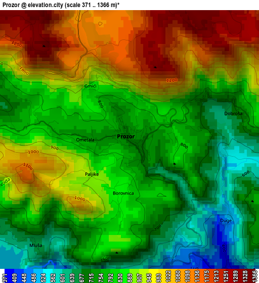
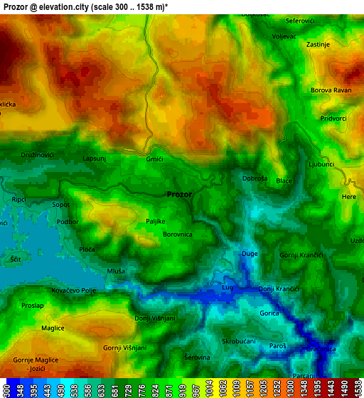
Below is the Elevation map of Prozor, which displays elevation range with different colors. Scale of the first map is from 371 to 1366 m (1217 to 4482 ft) with average elevation of 862 meters (=2828 ft) [note 1]
These maps also provides idea of topography and contour of this city, they are displayed at different zoom levels. More info about maps, scale and edge coordinates you can find below images.
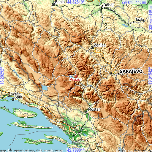
| \ | Map #1 | Map #2 | Topo.Map |
| Scale [m] | 371..1366 m | 300..1538 m | × |
| Scale [ft] | 1217..4482 ft | 984..5046 ft | × |
| Average | 862 m = 2828 ft | 884.7 m = 2903 ft | × |
| Width | 7.05 km = 4.4 mi | 14.1 km = 8.8 mi | 225.6 km = 140.2 mi |
| Height | 7.05 km = 4.4 mi | 14.1 km = 8.8 mi | 225.6 km = 140.2 mi |
| ↑Max Latitude | 43.853918° | 43.885599° | 44.82819° |
| Latitude at center | 43.82222° | 43.82222° | 43.82222° |
| ↓Min Latitude | 43.790505° | 43.758774° | 42.79901° |
| ← Min Longitude | 17.565225° | 17.521279° | 16.20292° |
| Longitude center | 17.60917° | 17.60917° | 17.60917° |
| →Max Longitude | 17.653115° | 17.697061° | 19.01542° |
Nearby cities:
Cities around Prozor sort by population:
• Bugojno elevation 565 m
29 km,  334°
334°
• Konjic 286 m
34.1 km,  123°
123°
• Fojnica 578 m
28.1 km,  57°
57°
• Tomislavgrad 904 m
32.9 km,  249°
249°
• Gornji Vakuf 671 m
13 km,  352°
352°
• Jablanica 199 m
21.8 km,  145°
145°
• Pajić Polje 620 m
18.3 km,  339°
339°
• Rumboci 712 m
8.6 km,  276°
276°
• Voljevac 767 m
7.4 km,  32°
32°
• Polje-Bijela 339 m
36 km,  125°
125°
• Kreševo 607 m
35.1 km,  82°
82°
• Kupres 1175 m
32.7 km,  305°
305°
Multilingual:
 En español:
Prozor elevación 711 m.
 En France:
Prozor élévation 711 m.


Sources and notes:
- [note 1] Map square and city borders are not equal. Map elevation data is calculated only from area inside that square.
- [src 1] Elevation data from geonames database provided with same terms of usage.
- [src 2] The elevation map of Prozor is generated using elevation data from NASA's 3 arcsec (90m) resolution SRTM data.
- [src 3] Base (background) map © OpenStreetMap contributors tiles are generated by Geofabrik and OpenTopoMap.
Copyright & License:
This Prozor Elevation Map is licensed under CC BY-SA. You may reuse any part from this page, if you give a proper credit by linking to this URL:
 More info on terms of use page.