Bosnia and Herzegovina elevation
On our site we have elevation data and maps for 263 cities from Bosnia and Herzegovina including Sarajevo as capital of the country.
Bosnia and Herzegovina on topographic map
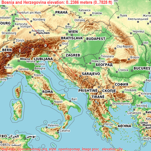
Bosnia and Herzegovina elevation extremes
Land surface elevation extremes in Bosnia and Herzegovina:
- Highest point in Bosnia and Herzegovina: Maglić with 2386 meters (=7828 ft)
- Lowest point: Adriatic Sea with 0 meters (=0 ft)
- Elevation span: 2386 m (=7828 ft)
Statistics
- Main average elevation: 500 meters (= 1640 ft)
- Average elevation of cities: 363 m (= 1191 ft), and this is 33 m (108 ft) below average city elevation worldwide..[1]
- Area: 51,129 km² (= 19,741 sq mi)
- Population: 4,590,000


This is only the list of largest 150 cities in ABC order:
If the city you are looking for is not listed, use the search box above.
Search by letter:
B C D F G H I J K L M N O P R S T U V Z
B:
Banja Luka Banovići Bihać Bijeljina Bila Bileća Blagaj Blatnica Bosanska Krupa Bosansko Grahovo Bratunac Brčko Brod Bugojno Busovača Bužim
C:
Čapljina Cazin Čelinac Čitluk Ćoralići Crnići
D:
Derventa Divičani Doboj Donja Mahala Donji Vakuf Dubrave Gornje
F:
Foča Fojnica
G:
Goražde Gornja Koprivna Gornja Tuzla Gornje Živinice Gornji Vakuf Gostovići Gračanica Gradačac Gradiška Gromiljak Grude
H:
Hadžići Hiseti
I:
Ilijaš
J:
Jablanica Jajce Janja Jelah Jezerski
K:
Kačuni Kakanj Kalenderovci Donji Kiseljak Kladanj Ključ Kneževo Knežica Konjic Kostajnica Kotor Varoš Kovači Kozarska Dubica
L:
Laktaši Lamovita Livno Ljubinje Ljubuški
M:
Maglaj Maglajani Mahala Mala Kladuša Maslovare Mejdan - Obilićevo Milići Mionica Mostar Mrkonjić Grad
N:
Nevesinje Novi Grad Novi Šeher Novi Travnik
O:
Odžak Omarska Orahovica Donja Orguz Ostrožac Otoka
P:
Pale Pazarić Pećigrad Podhum Podzvizd Potoci Priboj Prijedor Prnjavor Prozor
R:
Rodoč Rogatica
S:
Sanica Sanski Most Sarajevo Šekovići Šipovo Široki Brijeg Sladna Sokolac Solina Srbac Srebrenik Stijena Stjepan-Polje Stolac Stupari Šturlić Šumatac Svodna
T:
Tešanj Tešanjka Teslić Todorovo Tojšići Tomislavgrad Travnik Trebinje Trn Tržačka Raštela Turbe Tuzla
U:
Ustikolina
V:
Vareš Varoška Rijeka Velagići Velika Kladuša Velika Obarska Višegrad Visoko Vitez Vitina Vlasenica Vogošća Vrnograč
Z:
Zabrišće Zavidovići Zborište Željezno Polje Zenica Žepče Živinice Zvornik
15 most populated cities are in red/bold font style.

B:
Banja Luka Banovići Bihać Bijeljina Bila Bileća Blagaj Blatnica Bosanska Krupa Bosansko Grahovo Bratunac Brčko Brod Bugojno Busovača Bužim
C:
Čapljina Cazin Čelinac Čitluk Ćoralići Crnići
D:
Derventa Divičani Doboj Donja Mahala Donji Vakuf Dubrave Gornje
F:
Foča Fojnica
G:
Goražde Gornja Koprivna Gornja Tuzla Gornje Živinice Gornji Vakuf Gostovići Gračanica Gradačac Gradiška Gromiljak Grude
H:
Hadžići Hiseti
I:
Ilijaš
J:
Jablanica Jajce Janja Jelah Jezerski
K:
Kačuni Kakanj Kalenderovci Donji Kiseljak Kladanj Ključ Kneževo Knežica Konjic Kostajnica Kotor Varoš Kovači Kozarska Dubica
L:
Laktaši Lamovita Livno Ljubinje Ljubuški
M:
Maglaj Maglajani Mahala Mala Kladuša Maslovare Mejdan - Obilićevo Milići Mionica Mostar Mrkonjić Grad
N:
Nevesinje Novi Grad Novi Šeher Novi Travnik
O:
Odžak Omarska Orahovica Donja Orguz Ostrožac Otoka
P:
Pale Pazarić Pećigrad Podhum Podzvizd Potoci Priboj Prijedor Prnjavor Prozor
R:
Rodoč Rogatica
S:
Sanica Sanski Most Sarajevo Šekovići Šipovo Široki Brijeg Sladna Sokolac Solina Srbac Srebrenik Stijena Stjepan-Polje Stolac Stupari Šturlić Šumatac Svodna
T:
Tešanj Tešanjka Teslić Todorovo Tojšići Tomislavgrad Travnik Trebinje Trn Tržačka Raštela Turbe Tuzla
U:
Ustikolina
V:
Vareš Varoška Rijeka Velagići Velika Kladuša Velika Obarska Višegrad Visoko Vitez Vitina Vlasenica Vogošća Vrnograč
Z:
Zabrišće Zavidovići Zborište Željezno Polje Zenica Žepče Živinice Zvornik
Sources
- Elevation extremes by country from wikipedia.
- Base map data: © OpenStreetMap contributors, | map style: © OpenTopoMap (CC-BY-SA)
- [1] Calculated only from 263 cities in our database
- Other city data from geonames.org with taken over terms of usage.
- Min/max latitude and longitude coordinates per country from latitudelongitude.org website.