Tešanjka elevation
Tešanjka (Federation of B&H), Bosnia and Herzegovina elevation is 157 meters and Tešanjka elevation in feet is 515 ft above sea level [src 1]. Tešanjka is a populated place (feature code) with elevation that is 206 meters (676 ft) smaller than average city elevation in Bosnia and Herzegovina.
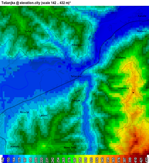
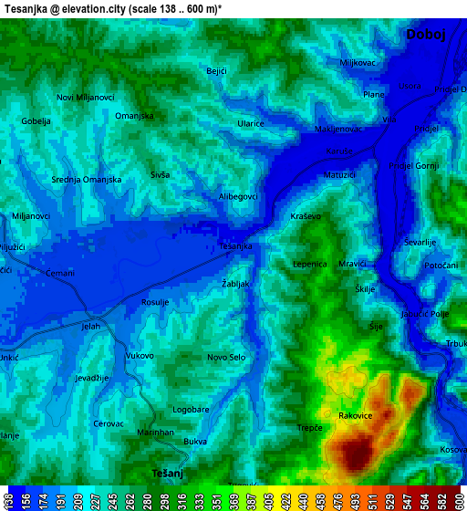
Below is the Elevation map of Tešanjka, which displays elevation range with different colors. Scale of the first map is from 142 to 432 m (466 to 1417 ft) with average elevation of 216.5 meters (=710 ft) [note 1]
These maps also provides idea of topography and contour of this city, they are displayed at different zoom levels. More info about maps, scale and edge coordinates you can find below images.
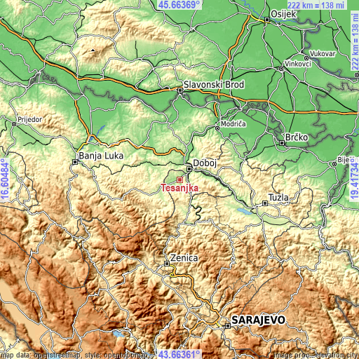
| \ | Map #1 | Map #2 | Topo.Map |
| Scale [m] | 142..432 m | 138..600 m | × |
| Scale [ft] | 466..1417 ft | 453..1969 ft | × |
| Average | 216.5 m = 710 ft | 232 m = 761 ft | × |
| Width | 6.95 km = 4.3 mi | 13.9 km = 8.6 mi | 222.4 km = 138.2 mi |
| Height | 6.95 km = 4.3 mi | 13.9 km = 8.6 mi | 222.4 km = 138.2 mi |
| ↑Max Latitude | 44.703523° | 44.734749° | 45.66369° |
| Latitude at center | 44.67228° | 44.67228° | 44.67228° |
| ↓Min Latitude | 44.64102° | 44.609744° | 43.66361° |
| ← Min Longitude | 17.967145° | 17.923199° | 16.60484° |
| Longitude center | 18.01109° | 18.01109° | 18.01109° |
| →Max Longitude | 18.055035° | 18.098981° | 19.41734° |
Nearby cities:
Cities around Tešanjka sort by population:
• Doboj elevation 144 m
8.9 km,  42°
42°
• Tešanj 232 m
7 km,  196°
196°
• Maglaj 177 m
15.5 km,  153°
153°
• Teslić 202 m
14 km,  238°
238°
• Jelah 184 m
4.6 km, 243°
• Novi Šeher 237 m
18 km,  176°
176°
• Lukavica 205 m
16.1 km,  50°
50°
• Karadaglije 276 m
11.3 km, 177°
• Stanari 230 m
16.6 km,  299°
299°
• Omanjska 223 m
5.1 km, 304°
• Klokotnica 196 m
15.6 km,  64°
64°
• Matuzići 248 m
3.4 km, 60°
Multilingual:
 En español:
Tešanjka elevación 157 m.
 En France:
Tešanjka élévation 157 m.
 Auf Deutsch:
Tešanjka höhe über dem Meeresspiegel ist 157 m.

Sources and notes:
- [note 1] Map square and city borders are not equal. Map elevation data is calculated only from area inside that square.
- [src 1] Elevation data from geonames database provided with same terms of usage.
- [src 2] The elevation map of Tešanjka is generated using elevation data from NASA's 3 arcsec (90m) resolution SRTM data.
- [src 3] Base (background) map © OpenStreetMap contributors tiles are generated by Geofabrik and OpenTopoMap.
Copyright & License:
This Tešanjka Elevation Map is licensed under CC BY-SA. You may reuse any part from this page, if you give a proper credit by linking to this URL:
 More info on terms of use page.