Maglaj elevation
Maglaj (Federation of B&H), Bosnia and Herzegovina elevation is 177 meters and Maglaj elevation in feet is 581 ft above sea level [src 1]. Maglaj is a seat of a third-order administrative division (feature code) with elevation that is 186 meters (610 ft) smaller than average city elevation in Bosnia and Herzegovina.
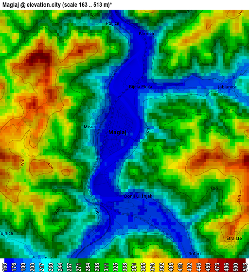
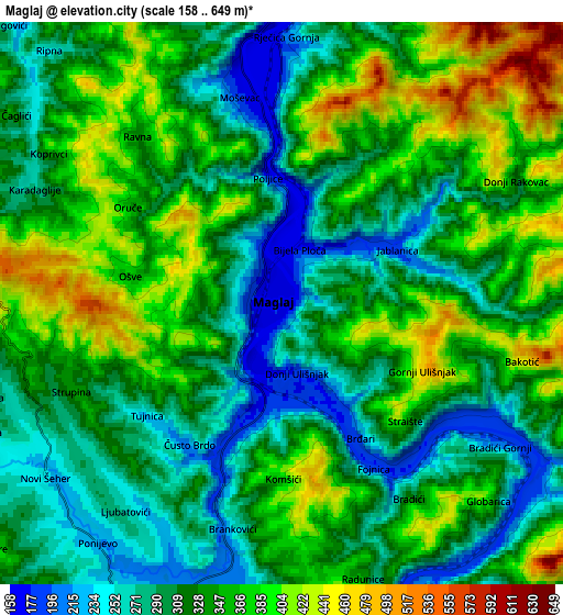
Below is the Elevation map of Maglaj, which displays elevation range with different colors. Scale of the first map is from 163 to 513 m (535 to 1683 ft) with average elevation of 292.1 meters (=958 ft) [note 1]
These maps also provides idea of topography and contour of this city, they are displayed at different zoom levels. More info about maps, scale and edge coordinates you can find below images.
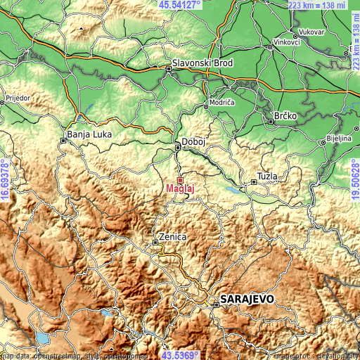
| \ | Map #1 | Map #2 | Topo.Map |
| Scale [m] | 163..513 m | 158..649 m | × |
| Scale [ft] | 535..1683 ft | 518..2129 ft | × |
| Average | 292.1 m = 958 ft | 331.1 m = 1086 ft | × |
| Width | 6.96 km = 4.3 mi | 13.93 km = 8.7 mi | 222.9 km = 138.5 mi |
| Height | 6.96 km = 4.3 mi | 13.93 km = 8.7 mi | 222.9 km = 138.5 mi |
| ↑Max Latitude | 44.57902° | 44.610313° | 45.54127° |
| Latitude at center | 44.54771° | 44.54771° | 44.54771° |
| ↓Min Latitude | 44.516383° | 44.48504° | 43.5369° |
| ← Min Longitude | 18.056085° | 18.012139° | 16.69378° |
| Longitude center | 18.10003° | 18.10003° | 18.10003° |
| →Max Longitude | 18.143975° | 18.187921° | 19.50628° |
Nearby cities:
Cities around Maglaj sort by population:
• Zavidovići elevation 208 m
12 km,  160°
160°
• Žepče 231 m
14.3 km,  200°
200°
• Tešanj 232 m
11.5 km,  308°
308°
• Kovači 364 m
13.8 km,  142°
142°
• Gostovići 338 m
16.2 km, 159°
• Tešanjka 157 m
15.5 km,  333°
333°
• Jelah 184 m
16.3 km,  316°
316°
• Novi Šeher 237 m
7.2 km,  234°
234°
• Dubravica 381 m
11.9 km,  172°
172°
• Karadaglije 276 m
7 km,  291°
291°
• Liješnica 281 m
6.2 km, 197°
• Matuzići 248 m
16.1 km,  345°
345°
Multilingual:
 En español:
Maglaj elevación 177 m.
 En France:
Maglaj élévation 177 m.


Sources and notes:
- [note 1] Map square and city borders are not equal. Map elevation data is calculated only from area inside that square.
- [src 1] Elevation data from geonames database provided with same terms of usage.
- [src 2] The elevation map of Maglaj is generated using elevation data from NASA's 3 arcsec (90m) resolution SRTM data.
- [src 3] Base (background) map © OpenStreetMap contributors tiles are generated by Geofabrik and OpenTopoMap.
Copyright & License:
This Maglaj Elevation Map is licensed under CC BY-SA. You may reuse any part from this page, if you give a proper credit by linking to this URL:
 More info on terms of use page.