Lamovita elevation
Lamovita (Srpska), Bosnia and Herzegovina elevation is 191 meters and Lamovita elevation in feet is 627 ft above sea level [src 1]. Lamovita is a populated locality (feature code) with elevation that is 172 meters (564 ft) smaller than average city elevation in Bosnia and Herzegovina.
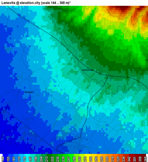
Below is the Elevation map of Lamovita, which displays elevation range with different colors. Scale of the first map is from 144 to 368 m (472 to 1207 ft) with average elevation of 191.2 meters (=627 ft) [note 1]
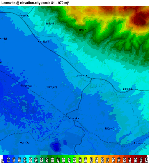
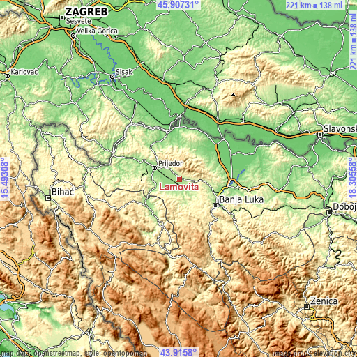
These maps also provides idea of topography and contour of this city, they are displayed at different zoom levels. More info about maps, scale and edge coordinates you can find below images.
| \ | Map #1 | Map #2 | Topo.Map |
| Scale [m] | 144..368 m | 81..970 m | × |
| Scale [ft] | 472..1207 ft | 266..3182 ft | × |
| Average | 191.2 m = 627 ft | 244.5 m = 802 ft | × |
| Width | 6.92 km = 4.3 mi | 13.84 km = 8.6 mi | 221.4 km = 137.6 mi |
| Height | 6.92 km = 4.3 mi | 13.84 km = 8.6 mi | 221.4 km = 137.6 mi |
| ↑Max Latitude | 44.951289° | 44.982381° | 45.90731° |
| Latitude at center | 44.92018° | 44.92018° | 44.92018° |
| ↓Min Latitude | 44.889054° | 44.857912° | 43.9158° |
| ← Min Longitude | 16.855385° | 16.811439° | 15.49308° |
| Longitude center | 16.89933° | 16.89933° | 16.89933° |
| →Max Longitude | 16.943275° | 16.987221° | 18.30558° |
Nearby cities:
Cities around Lamovita sort by population:
• Banja Luka elevation 164 m
28.1 km,  124°
124°
• Prijedor 140 m
16 km,  294°
294°
• Sanski Most 158 m
25 km,  227°
227°
• Trn 135 m
27.4 km,  104°
104°
• Omarska 163 m
3.2 km,  181°
181°
• Mejdan - Obilićevo 161 m
28.8 km,  127°
127°
• Hiseti 172 m
28.3 km, 128°
• Knežica 152 m
27 km,  319°
319°
• Bronzani Majdan 275 m
14.6 km,  167°
167°
• Piskavica 175 m
8.4 km, 134°
• Marićka 152 m
6.8 km,  210°
210°
• Oštra Luka 268 m
19.9 km,  250°
250°
Multilingual:
 En español:
Lamovita elevación 191 m.
 En France:
Lamovita élévation 191 m.
 Auf Deutsch:
Lamovita höhe über dem Meeresspiegel ist 191 m.

Sources and notes:
- [note 1] Map square and city borders are not equal. Map elevation data is calculated only from area inside that square.
- [src 1] Elevation data from geonames database provided with same terms of usage.
- [src 2] The elevation map of Lamovita is generated using elevation data from NASA's 3 arcsec (90m) resolution SRTM data.
- [src 3] Base (background) map © OpenStreetMap contributors tiles are generated by Geofabrik and OpenTopoMap.
Copyright & License:
This Lamovita Elevation Map is licensed under CC BY-SA. You may reuse any part from this page, if you give a proper credit by linking to this URL:
 More info on terms of use page.