Mejdan - Obilićevo elevation
Mejdan - Obilićevo (Srpska), Bosnia and Herzegovina elevation is 161 meters and Mejdan - Obilićevo elevation in feet is 528 ft above sea level [src 1]. Mejdan - Obilićevo is a section of populated place (feature code) with elevation that is 202 meters (663 ft) smaller than average city elevation in Bosnia and Herzegovina.
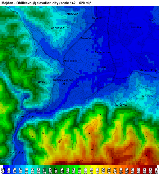
Below is the Elevation map of Mejdan - Obilićevo, which displays elevation range with different colors. Scale of the first map is from 142 to 620 m (466 to 2034 ft) with average elevation of 260.8 meters (=856 ft) [note 1]
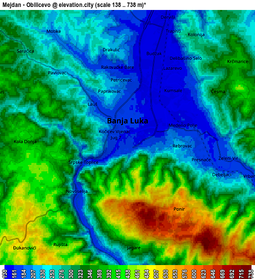
These maps also provides idea of topography and contour of this city, they are displayed at different zoom levels. More info about maps, scale and edge coordinates you can find below images.
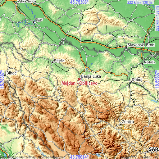
| \ | Map #1 | Map #2 | Topo.Map |
| Scale [m] | 142..620 m | 138..738 m | × |
| Scale [ft] | 466..2034 ft | 453..2421 ft | × |
| Average | 260.8 m = 856 ft | 318.9 m = 1046 ft | × |
| Width | 6.94 km = 4.3 mi | 13.88 km = 8.6 mi | 222 km = 137.9 mi |
| Height | 6.94 km = 4.3 mi | 13.88 km = 8.6 mi | 222 km = 137.9 mi |
| ↑Max Latitude | 44.794434° | 44.825611° | 45.75308° |
| Latitude at center | 44.76324° | 44.76324° | 44.76324° |
| ↓Min Latitude | 44.732029° | 44.700802° | 43.75614° |
| ← Min Longitude | 17.146175° | 17.102229° | 15.78387° |
| Longitude center | 17.19012° | 17.19012° | 17.19012° |
| →Max Longitude | 17.234065° | 17.278011° | 18.59637° |
Nearby cities:
Cities around Mejdan - Obilićevo sort by population:
• Banja Luka elevation 164 m
1.7 km,  9°
9°
• Trn 135 m
11.2 km,  18°
18°
• Čelinac 194 m
11.4 km,  112°
112°
• Laktaši 124 m
18.4 km,  28°
28°
• Kotor Varoš 281 m
21.6 km,  138°
138°
• Hiseti 172 m
0.9 km,  254°
254°
• Maglajani 112 m
24.3 km, 31°
• Bronzani Majdan 275 m
20 km,  279°
279°
• Piskavica 175 m
20.6 km,  304°
304°
• Starcevica 206 m
1.8 km, 111°
• Krupa na Vrbasu 221 m
16.5 km,  192°
192°
• Čelinac 201 m
10.5 km,  104°
104°
Multilingual:
 En español:
Mejdan - Obilićevo elevación 161 m.
 En France:
Mejdan - Obilićevo élévation 161 m.
 Auf Deutsch:
Mejdan - Obilićevo höhe über dem Meeresspiegel ist 161 m.
 На русском:
Mejdan - Obilićevo высота над уровнем моря 161 м
Sources and notes:
- [note 1] Map square and city borders are not equal. Map elevation data is calculated only from area inside that square.
- [src 1] Elevation data from geonames database provided with same terms of usage.
- [src 2] The elevation map of Mejdan - Obilićevo is generated using elevation data from NASA's 3 arcsec (90m) resolution SRTM data.
- [src 3] Base (background) map © OpenStreetMap contributors tiles are generated by Geofabrik and OpenTopoMap.
Copyright & License:
This Mejdan - Obilićevo Elevation Map is licensed under CC BY-SA. You may reuse any part from this page, if you give a proper credit by linking to this URL:
 More info on terms of use page.