Prijedor elevation
Prijedor (Srpska), Bosnia and Herzegovina elevation is 140 meters and Prijedor elevation in feet is 459 ft above sea level [src 1]. Prijedor is a seat of a second-order administrative division (feature code) with elevation that is 223 meters (732 ft) smaller than average city elevation in Bosnia and Herzegovina.
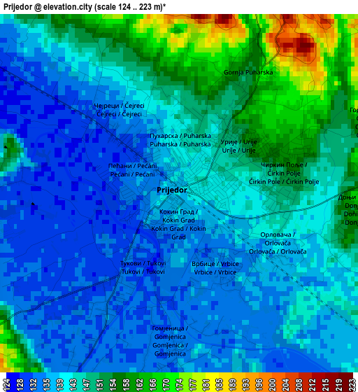
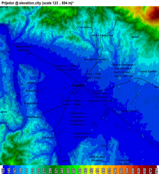
Below is the Elevation map of Prijedor, which displays elevation range with different colors. Scale of the first map is from 124 to 223 m (407 to 732 ft) with average elevation of 143.6 meters (=471 ft) [note 1]
These maps also provides idea of topography and contour of this city, they are displayed at different zoom levels. More info about maps, scale and edge coordinates you can find below images.
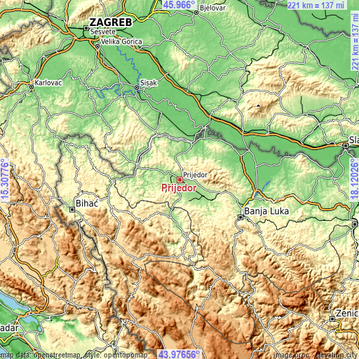
| \ | Map #1 | Map #2 | Topo.Map |
| Scale [m] | 124..223 m | 123..694 m | × |
| Scale [ft] | 407..732 ft | 404..2277 ft | × |
| Average | 143.6 m = 471 ft | 188.4 m = 618 ft | × |
| Width | 6.91 km = 4.3 mi | 13.83 km = 8.6 mi | 221.2 km = 137.4 mi |
| Height | 6.91 km = 4.3 mi | 13.83 km = 8.6 mi | 221.2 km = 137.4 mi |
| ↑Max Latitude | 45.010986° | 45.042046° | 45.966° |
| Latitude at center | 44.97991° | 44.97991° | 44.97991° |
| ↓Min Latitude | 44.948817° | 44.917706° | 43.97656° |
| ← Min Longitude | 16.670065° | 16.626119° | 15.30776° |
| Longitude center | 16.71401° | 16.71401° | 16.71401° |
| →Max Longitude | 16.757955° | 16.801901° | 18.12026° |
Nearby cities:
Cities around Prijedor sort by population:
• Sanski Most elevation 158 m
24 km,  188°
188°
• Kozarska Dubica 99 m
23.1 km,  18°
18°
• Novi Grad 127 m
27.4 km,  285°
285°
• Omarska 163 m
17.5 km,  124°
124°
• Knežica 152 m
14.3 km,  348°
348°
• Lamovita 191 m
16 km,  114°
114°
• Svodna 144 m
15.1 km,  295°
295°
• Bronzani Majdan 275 m
27.4 km,  139°
139°
• Piskavica 175 m
24 km, 121°
• Marićka 152 m
16.7 km, 138°
• Dobrljin 121 m
26.5 km,  315°
315°
• Oštra Luka 268 m
13.9 km,  197°
197°
Multilingual:
 En español:
Prijedor elevación 140 m.
 En France:
Prijedor élévation 140 m.
 Auf Deutsch:
Prijedor höhe über dem Meeresspiegel ist 140 m.

Sources and notes:
- [note 1] Map square and city borders are not equal. Map elevation data is calculated only from area inside that square.
- [src 1] Elevation data from geonames database provided with same terms of usage.
- [src 2] The elevation map of Prijedor is generated using elevation data from NASA's 3 arcsec (90m) resolution SRTM data.
- [src 3] Base (background) map © OpenStreetMap contributors tiles are generated by Geofabrik and OpenTopoMap.
Copyright & License:
This Prijedor Elevation Map is licensed under CC BY-SA. You may reuse any part from this page, if you give a proper credit by linking to this URL:
 More info on terms of use page.