Bratunac elevation
Bratunac (Srpska), Bosnia and Herzegovina elevation is 190 meters and Bratunac elevation in feet is 623 ft above sea level [src 1]. Bratunac is a seat of a second-order administrative division (feature code) with elevation that is 173 meters (568 ft) smaller than average city elevation in Bosnia and Herzegovina.
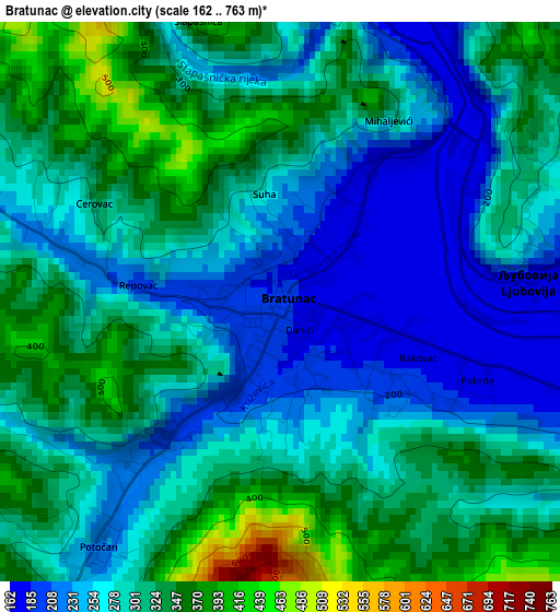
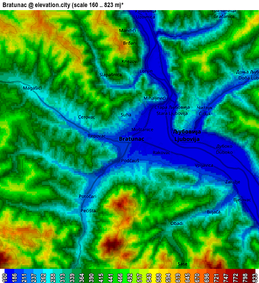
Below is the Elevation map of Bratunac, which displays elevation range with different colors. Scale of the first map is from 162 to 763 m (531 to 2503 ft) with average elevation of 289.7 meters (=950 ft) [note 1]
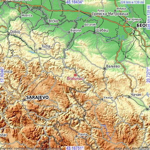
These maps also provides idea of topography and contour of this city, they are displayed at different zoom levels. More info about maps, scale and edge coordinates you can find below images.
| \ | Map #1 | Map #2 | Topo.Map |
| Scale [m] | 162..763 m | 160..823 m | × |
| Scale [ft] | 531..2503 ft | 525..2700 ft | × |
| Average | 289.7 m = 950 ft | 368.1 m = 1208 ft | × |
| Width | 7.01 km = 4.4 mi | 14.02 km = 8.7 mi | 224.3 km = 139.4 mi |
| Height | 7.01 km = 4.4 mi | 14.02 km = 8.7 mi | 224.2 km = 139.3 mi |
| ↑Max Latitude | 44.216055° | 44.247543° | 45.18434° |
| Latitude at center | 44.18455° | 44.18455° | 44.18455° |
| ↓Min Latitude | 44.153028° | 44.12149° | 43.16751° |
| ← Min Longitude | 19.286905° | 19.242959° | 17.9246° |
| Longitude center | 19.33085° | 19.33085° | 19.33085° |
| →Max Longitude | 19.374795° | 19.418741° | 20.7371° |
Nearby cities:
Cities around Bratunac sort by population:
• Milići elevation 426 m
19.1 km,  265°
265°
• Zvornik 163 m
28.9 km,  320°
320°
• Šekovići 340 m
40 km,  288°
288°
• Višegrad 311 m
44.8 km,  183°
183°
• Rogatica 528 m
50.2 km,  211°
211°
• Vlasenica 660 m
31.1 km, 269°
• Han Pijesak 1086 m
32.3 km,  249°
249°
• Srebrenica 371 m
9 km,  197°
197°
• Petkovci 257 m
37.6 km,  327°
327°
• Sapna 288 m
44.3 km, 323°
• Kalesija 293 m
43.9 km,  309°
309°
• Osmaci 287 m
40.9 km, 306°
Multilingual:
 En español:
Bratunac elevación 190 m.
 En France:
Bratunac élévation 190 m.
 Auf Deutsch:
Bratunac höhe über dem Meeresspiegel ist 190 m.

Sources and notes:
- [note 1] Map square and city borders are not equal. Map elevation data is calculated only from area inside that square.
- [src 1] Elevation data from geonames database provided with same terms of usage.
- [src 2] The elevation map of Bratunac is generated using elevation data from NASA's 3 arcsec (90m) resolution SRTM data.
- [src 3] Base (background) map © OpenStreetMap contributors tiles are generated by Geofabrik and OpenTopoMap.
Copyright & License:
This Bratunac Elevation Map is licensed under CC BY-SA. You may reuse any part from this page, if you give a proper credit by linking to this URL:
 More info on terms of use page.